Park Hills, Missouri

Last updated

Park Hills, Missouri
St. Francois County Missouri Incorporated and Unincorporated areas Park Hills Highlighted.svg
Location of Park Hills, Missouri
Coordinates: 37°50′40″N90°30′40″W / 37.84444°N 90.51111°W / 37.84444; -90.51111
Country United States
State Missouri
County St. Francois
Area
[1]
  Total20.43 sq mi (52.91 km2)
  Land20.34 sq mi (52.67 km2)
  Water0.09 sq mi (0.23 km2)
Elevation
[2]
758 ft (231 m)
Population
 (2020)
  Total8,587
  Density422.24/sq mi (163.03/km2)
Time zone UTC-6 (Central (CST))
  Summer (DST) UTC-5 (CDT)
Zip code
63601
Area code 573
FIPS code 29-56272 [3]
GNIS feature ID1669609 [2]
Website http://www.parkhillsmo.net/

Park Hills is a city in St. Francois County, Missouri, United States. The population was 8,587 at the 2020 census.

Contents

History

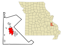
The city was formed in an unusual four-way merger that took place in January 1994, in which the cities of Flat River, Elvins, Esther and the village of Rivermines joined to form the new city of Park Hills. The formerly incorporated village of Fairview Acres had previously merged with Flat River on November 8, 1983. The name of the new city was selected by entries submitted to a committee made up of citizens of the four cities. The name Park Hills was submitted by Mildred Lee, a lifelong resident and a former teacher of Flat River. The inspiration came from its hilly terrain in the foothills of the Ozark Mountains and the many parks that surround the area. Park Hills is located 7 miles northwest of Farmington, Missouri and approximately 65 miles south of St. Louis. It is adjacent to St. Joe State Park, and nearby the state parks of St. Francois, Hawn, Elephant Rocks, Johnson's Shut-Ins, Taum Sauk Mountain, and Washington.

Park Hills is home to Mineral Area College, formerly known as Flat River Junior College. The town is located in the Old Lead Belt, formerly a large lead mining district.

The Eugene Field School was added to the National Register of Historic Places in 2005. [4]

Geography

Park Hills is located at 37°50′40″N90°30′40″W / 37.84444°N 90.51111°W / 37.84444; -90.51111 (37.844538, -90.511038). [5]

According to the United States Census Bureau, the city has a total area of 20.42 square miles (52.89 km2), of which 20.33 square miles (52.65 km2) is land and 0.09 square miles (0.23 km2) is water. [6]

Demographics

Historical population
CensusPop.Note
2000 7,861
2010 8,75911.4%
2020 8,587−2.0%
U.S. Decennial Census [7] 2020 [8]

2020 census

The 2020 United States census [9] counted 8,587 people, 3,384 households, and 2,155 families in Park Hills. The population density was 422.2 per square mile (163.0/km2). There were 3,943 housing units at an average density of 193.9 per square mile (74.9/km2). The racial makeup was 90.53% (7,774) white, 1.9% (163) black or African-American, 0.49% (42) Native American, 0.27% (23) Asian, 0.05% (4) Pacific Islander, 1.4% (120) from other races, and 5.37% (461) from two or more races. Hispanic or Latino of any race was 1.5% (126) of the population.

Of the 3,384 households, 34.3% had children under the age of 18; 41.4% were married couples living together; 24.1% had a female householder with no husband present. Of all households, 25.7% consisted of individuals and 8.2% had someone living alone who was 65 years of age or older. The average household size was 2.5 and the average family size was 3.0.

26.4% of the population was under the age of 18, 14.2% from 18 to 24, 28.0% from 25 to 44, 21.1% from 45 to 64, and 9.5% who were 65 years of age or older. The median age was 32.8 years. For every 100 females, the population had 103.2 males. For every 100 females ages 18 and older, there were 95.5 males.

The 2016-2020 5-year American Community Survey [10] estimates show that the median household income was $38,065 (with a margin of error of +/- $7,153) and the median family income was $42,817 (+/- $4,987). Males had a median income of $32,167 (+/- $3,224) versus $21,697 (+/- $2,183) for females. The median income for those above 16 years old was $26,788 (+/- $4,293). Approximately, 23.0% of families and 24.4% of the population were below the poverty line, including 30.1% of those under the age of 18 and 14.2% of those ages 65 or over.

2010 census

At the 2010 census there were 8,759 people, 3,551 households, and 2,154 families living in the city. The population density was 430.8 inhabitants per square mile (166.3/km2). There were 3,943 housing units at an average density of 193.9 per square mile (74.9/km2). The racial makeup of the city was 95.34% White, 1.96% Black or African American, 0.47% Native American, 0.41% Asian, 0.13% Native Hawaiian or Pacific Islander, 0.25% from other races, and 1.44% from two or more races. Hispanic or Latino of any race were 1.27%. [11]

Of the 3,551 households 35.3% had children under the age of 18 living with them, 38.7% were married couples living together, 15.8% had a female householder with no husband present, 6.1% had a male householder with no wife present, and 39.3% were non-families. 31.1% of households were one person and 11% were one person aged 65 or older. The average household size was 2.44 and the average family size was 3.04.

The median age was 32.7 years. 26.2% of residents were under the age of 18; 12.1% were between the ages of 18 and 24; 26.8% were from 25 to 44; 23.2% were from 45 to 64; and 11.7% were 65 or older. The gender makeup of the city was 48.4% male and 51.6% female.

2000 census

At the 2000 census there were 7,861 people, 3,181 households, and 2,070 families living in the city. The population density was 392.5 inhabitants per square mile (151.5/km2). There were 3,520 housing units at an average density of 175.7 per square mile (67.8/km2). The racial makeup of the city was 97.62% White, 0.32% African American, 0.27% Native American, 0.45% Asian, 0.03% Pacific Islander, 0.41% from other races, and 0.92% from two or more races. Hispanic or Latino of any race were 0.92%. [3]

Of the 3,181 households 32.3% had children under the age of 18 living with them, 45.5% were married couples living together, 15.3% had a female householder with no husband present, and 34.9% were non-families. 28.7% of households were one person and 12.5% were one person aged 65 or older. The average household size was 2.45 and the average family size was 2.99.

The age distribution was 26.6% under the age of 18, 11.2% from 18 to 24, 29.1% from 25 to 44, 19.6% from 45 to 64, and 13.5% 65 or older. The median age was 34 years. For every 100 females there were 89.6 males. For every 100 females age 18 and over, there were 85.0 males.

The median household income was $25,277 and the median family income was $30,663. Males had a median income of $26,900 versus $17,613 for females. The per capita income for the city was $13,048. About 17.6% of families and 21.1% of the population were below the poverty line, including 28.8% of those under age 18 and 12.2% of those age 65 or over.

Education

Public education in Park Hills is administered by Central R-III School District. [12]

Park Hills has a lending library, the Park Hills Public Library. [13]

Arts and culture

Some of the many places that bring people to Park Hills Missouri include Columbia Park located in the center of the city and includes a walking track, playground, an 18-hole disc golf course, and the Park Hills public pool, Park Hills Sports Complex which is home to many softball games; opening in March and closing in November.

Notable people

Related Research Articles

<span class="mw-page-title-main">Wheaton, Missouri</span> City in Missouri, United States

Wheaton is a city in Wheaton Township, Barry County, Missouri, United States. The population was 696 at the 2010 census.

<span class="mw-page-title-main">Rich Hill, Missouri</span> City in Missouri, United States

Rich Hill is a city in southern Bates County, Missouri, and is part of the Kansas City metropolitan area within the United States. The population was 1,232 at the 2020 census.

<span class="mw-page-title-main">Pleasant Hill, Missouri</span> City in Missouri, United States

Pleasant Hill is a city in Cass and Jackson counties, Missouri, United States. The population was 8,113 at the 2010 census. It is part of the Kansas City metropolitan area.

<span class="mw-page-title-main">Fremont Hills, Missouri</span> City in Missouri, United States

Fremont Hills is a city in Christian County, Missouri, United States. The population was 1,049 at the 2020 census. It is part of the Springfield, Missouri Metropolitan Statistical Area.

<span class="mw-page-title-main">Gladstone, Missouri</span> City in Missouri, United States

Gladstone is a city in Clay County, Missouri, United States and a suburb of Kansas City. The City of Gladstone is located about 10–20 minutes from downtown Kansas City, and about 10–20 minutes from Kansas City International Airport. As of the 2020 census, the city population was 27,063. It is part of the Kansas City metropolitan area.

<span class="mw-page-title-main">Smithville, Missouri</span> City in Missouri, United States

Smithville is a city in Clay and Platte counties in the U.S. state of Missouri and is part of the Kansas City metropolitan area, along the Little Platte River. The population was 10,406 at the 2020 United States Census.

<span class="mw-page-title-main">High Hill, Missouri</span> City in Missouri, United States

High Hill is a city in Montgomery County, Missouri, United States. The population was 186 at the 2020 census.

<span class="mw-page-title-main">Parkville, Missouri</span> City in Missouri, United States

Parkville is a city in Platte County, Missouri, United States and is a part of the Kansas City Metropolitan Area. The population was 7,177 at the 2020 census. Parkville is known for its antique shops, art galleries, and historic downtown. The city is home to Park University, English Landing Park, Platte Landing Park, and the National Golf Club of Kansas City. Large neighborhoods in Parkville include: Riss Lake, The National, Thousand Oaks, Creekside, Parkville Heights, River Hills, Riverchase, The Bluffs, Downtown, and Pinecrest.

<span class="mw-page-title-main">Riverside, Missouri</span> City in Missouri, United States

Riverside is a city in Platte County, Missouri and is part of the Kansas City metropolitan area within the United States. The population was 4,013 at the 2020 census.

<span class="mw-page-title-main">Breckenridge Hills, Missouri</span> City in Missouri, United States

Breckenridge Hills is a city in St. Louis County, Missouri, United States. As of the 2010 census, the city population was 4,746.

<span class="mw-page-title-main">Country Club Hills, Missouri</span> City in Missouri, United States

Country Club Hills is a city in St. Louis County, Missouri, United States. The population was 1,274 at the 2010 census.

<span class="mw-page-title-main">Crestwood, Missouri</span> City in the United States

Crestwood is a city in south St. Louis County, Missouri, United States, part of the Metropolitan Statistical Area known as Greater St. Louis. The population was 11,912 at the 2010 census.

<span class="mw-page-title-main">Crystal Lake Park, Missouri</span> City in Missouri, United States

Crystal Lake Park is a Missouri Class 4 city in St. Louis County, Missouri, United States. The population was 508 at the 2020 census.

<span class="mw-page-title-main">Flordell Hills, Missouri</span> City in Missouri, United States

Flordell Hills is a city in St. Louis County, Missouri, United States. The population was 822 at the 2010 census.

<span class="mw-page-title-main">Green Park, Missouri</span> City in Missouri, United States

Green Park is a city in St. Louis County, Missouri, United States. The population was 2,622 at the 2010 census.

<span class="mw-page-title-main">Hazelwood, Missouri</span> City in Missouri, United States

Hazelwood is a city in St. Louis County, Missouri, within Greater St. Louis. It is a second-ring northern suburb of St. Louis. Based on the 2020 United States census, the city had a total population of 25,485. It is located north of St. Louis-Lambert International Airport and is situated on Interstates 270 and 170, as well as the much-traveled Lindbergh Boulevard and Highway 370.

<span class="mw-page-title-main">Pasadena Hills, Missouri</span> City in Missouri, United States

Pasadena Hills is a city in St. Louis County, Missouri, United States. The population was 930 at the 2010 census. The entire city is listed on the National Register of Historic Places.

<span class="mw-page-title-main">Pasadena Park, Missouri</span> Village in Missouri, United States

Pasadena Park is a village in St. Louis County, Missouri, United States. The population was 470 at the 2010 census. It is part of the Normandy School District, and is distinct from the city of Pasadena Hills.

<span class="mw-page-title-main">Wildwood, Missouri</span> City in Missouri, United States

Wildwood is a city in St. Louis County, Missouri, United States. It is located in the far western portion of the county. As of the 2020 census, the population was 35,417. Wildwood is the home of the Al Foster Trail, and numerous other trails, parks, and reserves such as Rockwoods Reservation and Babler State Park.

<span class="mw-page-title-main">Sunset Hills, Missouri</span> City in Missouri, United States

Sunset Hills is a city in south St. Louis County, Missouri, United States. The population was 8,496 at the 2010 census.

References

  1. "ArcGIS REST Services Directory". United States Census Bureau. Retrieved August 28, 2022.
  2. 1 2 U.S. Geological Survey Geographic Names Information System: Park Hills, Missouri
  3. 1 2 "U.S. Census website". United States Census Bureau . Retrieved January 31, 2008.
  4. "National Register Information System". National Register of Historic Places . National Park Service. July 9, 2010.
  5. "US Gazetteer files: 2010, 2000, and 1990". United States Census Bureau. February 12, 2011. Retrieved April 23, 2011.
  6. "US Gazetteer files 2010". United States Census Bureau. Archived from the original on January 12, 2012. Retrieved July 8, 2012.
  7. "Census of Population and Housing". Census.gov. Retrieved June 4, 2015.
  8. "2020 Census Data". data.census.gov.
  9. "Explore Census Data". data.census.gov. Retrieved December 17, 2023.
  10. "Explore Census Data". data.census.gov. Retrieved December 17, 2023.
  11. "U.S. Census website". United States Census Bureau . Retrieved July 8, 2012.
  12. "Homepage". Central R-Iii School District. Retrieved June 4, 2019.
  13. "Missouri Public Libraries". PublicLibraries.com. Archived from the original on June 10, 2017. Retrieved June 2, 2019.