Terre du Lac, Missouri | |
|---|---|
 Interactive map of Terre du Lac, Missouri | |
| Coordinates: 37°54′11″N90°36′57″W / 37.90306°N 90.61583°W | |
| Country | United States |
| State | Missouri |
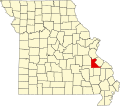
| County | St. Francois County |
| Area | |
• Total | 7.56 sq mi (19.58 km2) |
| • Land | 6.99 sq mi (18.10 km2) |
| • Water | 0.58 sq mi (1.49 km2) |
| Elevation | 905 ft (276 m) |
| Population (2020) | |
• Total | 2,478 |
| • Density | 354.7/sq mi (136.94/km2) |
| FIPS code | 29-72772 |
| GNIS feature ID | 2587116 [2] |
Terre du Lac is an unincorporated community and census-designated place in St. Francois and Washington counties in the U.S. state of Missouri. [2] [3] It uses zip code 63628, from neighboring Bonne Terre. As of the 2020 census, Terre du Lac had a population of 2,478. [4]
Contents
The recreational community is built around several man-made lakes and a golf course overlooking the Big River valley to the south. [3]