Goose Creek Lake, Missouri

Last updated
Goose Creek Lake, Missouri
USA Missouri location map.svg
Red pog.svg
Goose Creek Lake
Usa edcp location map.svg
Red pog.svg
Goose Creek Lake
Coordinates: 37°58′47″N90°21′9″W / 37.97972°N 90.35250°W / 37.97972; -90.35250 Coordinates: 37°58′47″N90°21′9″W / 37.97972°N 90.35250°W / 37.97972; -90.35250
CountryUnited States
State Missouri
Counties St. Francois
Ste. Genevieve
Townships Marion
Jackson
Area
[1]
  Total4.43 sq mi (11.47 km2)
  Land3.96 sq mi (10.25 km2)
  Water0.47 sq mi (1.22 km2)
Elevation
[2]
760 ft (230 m)
Population
 (2020)
  Total524
  Density132.39/sq mi (51.12/km2)
Time zone UTC-6 (Central (CST))
  Summer (DST) UTC-5 (CDT)
ZIP Code
Area code 573
FIPS code 29-27924
GNIS feature ID2806424 [2]

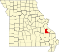
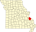
Goose Creek Lake is an unincorporated community and census-designated place (CDP) in St. Francois and Ste. Genevieve counties, Missouri, United States. The community is built around a lake of the same name, a reservoir impounding Goose Creek, an east-flowing tributary of Fourche Du Clos and part of the Establishment Creek watershed leading to the Mississippi River.

The community is in the northeast part of St. Francois County and extends east into the northwest part of Ste. Genevieve County. It is 3 miles (5 km) east of French Village, 15 miles (24 km) northeast of Bonne Terre, and 22 miles (35 km) west of Ste. Genevieve.

The community was first listed as a CDP prior to the 2020 census. [2]

Demographics

Historical population
CensusPop.
2020 524
U.S. Decennial Census [3]

Related Research Articles

<span class="mw-page-title-main">Ste. Genevieve County, Missouri</span> County in Missouri, United States

Sainte Genevieve County, often abbreviated Ste. Genevieve County, is a county located in the eastern portion of the U.S. state of Missouri. As of the 2020 census, the population was 18,479. The largest city and county seat is Ste. Genevieve. The county was officially organized on October 1, 1812, and is named after the Spanish district once located in the region, after Saint Genevieve, patroness of Paris, France.

<span class="mw-page-title-main">St. Francois County, Missouri</span> County in Missouri, United States

St. Francois County is a county located in the Lead Belt region in the U.S. state of Missouri. As of the 2020 census, the population was 66,922. The largest city and county seat is Farmington. The county was officially organized on December 19, 1821. It was named after the St. Francis River. The origin of the river's name is unclear. It might refer to St. Francis of Assisi. Another possibility is that Jacques Marquette, a Jesuit who explored the region in 1673, named the river for the Jesuit missionary Francis Xavier. Marquette had spent some time at the mission of St. Francois Xavier before his voyage and, as a Jesuit, was unlikely to have given the river a name honoring the Franciscans.

<span class="mw-page-title-main">Perry County, Missouri</span> County in Missouri, United States

Perry County is a county located in the southeastern portion of the U.S. state of Missouri. As of the 2020 census, the population was 18,956. Its county seat is Perryville. The county was officially organized on November 16, 1820 from Ste. Genevieve County and was named after Oliver Hazard Perry, a naval hero of the War of 1812.

<span class="mw-page-title-main">Monroe County, Illinois</span> County in Illinois, United States

Monroe County is a county located in the U.S. state of Illinois. According to the 2020 census, it had a population of 34,962. Its county seat and largest city is Waterloo.

<span class="mw-page-title-main">Ste. Genevieve, Missouri</span> City in Missouri, United States

Ste. Genevieve is a city in Ste. Genevieve Township and is the county seat of Ste. Genevieve County, Missouri, United States. The population was 4,999 at the 2020 census. Founded in 1735 by French Canadian colonists and settlers from east of the river, it was the first organized European settlement west of the Mississippi River in present-day Missouri. Today, it is home to Ste. Genevieve National Historical Park, the 422nd unit of the National Park Service.

<span class="mw-page-title-main">Highlands, Texas</span> Census-designated place in Texas, United States

Highlands is a census-designated place (CDP) located along the Union Pacific Railroad, north of Interstate 10 and west of Farm to Market Road 2100, in an industrialized area of unincorporated Harris County, Texas, United States. The population was 8,612 at the 2020 census.

<span class="mw-page-title-main">Jackson Township, Ste. Genevieve County, Missouri</span> Civil Township in Missouri, United States

Jackson Township is a subdivision of Ste. Genevieve County, Missouri, in the United States of America, and is one of the five townships located in Ste. Genevieve County.

<span class="mw-page-title-main">Cinque Hommes Township, Perry County, Missouri</span> Civil Township in Missouri, United States

Cinque Hommes is one of the eight townships located in Perry County, Missouri, in the United States of America.

<span class="mw-page-title-main">Saint Mary's Township, Perry County, Missouri</span> Civil Township in Missouri, United States

St. Marys is one of the eight townships located in Perry County, Missouri, in the United States of America.

<span class="mw-page-title-main">Beauvais Township, Ste. Genevieve County, Missouri</span> Civil Township in Missouri, United States

Beauvais Township is a subdivision of Ste. Genevieve County, Missouri, in the United States of America, and is one of the five townships located in Ste. Genevieve County.

<span class="mw-page-title-main">Saline Township, Ste. Genevieve County, Missouri</span> Civil Township in Missouri, United States

Saline Township is a subdivision of Ste. Genevieve County, Missouri, in the United States of America, and is one of the five townships located in Ste. Genevieve County.

<span class="mw-page-title-main">Union Township, Ste. Genevieve County, Missouri</span> Civil Township in Missouri, United States

Union Township is a subdivision of Ste. Genevieve County, Missouri, in the United States of America, and is one of the five townships located in Ste. Genevieve County.

<span class="mw-page-title-main">Ste. Genevieve Township, Ste. Genevieve County, Missouri</span> Civil Township in Missouri, United States

Ste. Genevieve Township is a subdivision of Ste. Genevieve County, Missouri, in the United States of America, and is one of the five townships located in Ste. Genevieve County.

Lake Viking is an unincorporated community and census-designated place (CDP) in Daviess County, Missouri, United States. The population was 486 at the 2020 census.

Dry Fork is a stream in Jefferson, St. Francois and Ste. Genevieve counties in the U.S. state of Missouri. It is a tributary of Plattin Creek.

Lake St. Clair is an unincorporated community and census-designated place (CDP) in Franklin County, Missouri, United States. It is in the southeast part of the county, surrounding a lake impounded on a tributary of Hoosier Creek, a south-flowing tributary of the Meramec River. The community is bordered to the north by the city of Saint Clair and is 54 miles (87 km) southwest of St. Louis.

Tarsney Lakes is an unincorporated community and census-designated place (CDP) in Jackson County, Missouri, United States. It is in the eastern part of the county, northeast of the unincorporated community of Tarsney, and consisting of residential neighborhoods surrounding Tarsney Lake and Wood Lake, just south of the West Fork of Sni-A-Bar Creek. It is 28 miles (45 km) southeast of downtown Kansas City.

Briarwood Estates is an unincorporated community and census-designated place (CDP) in Jefferson County, Missouri, United States. It is in the southern part of the county, northwest of De Soto. It is a residential community built around three lakes: Lake Briarwood, Fishermans Lake, and Spring Lake. Missouri Route 21 passes between Briarwood Estates and De Soto, leading northeast 44 miles (71 km) to St. Louis and southwest 24 miles (39 km) to Potosi.

Lake Timberline is an unincorporated community and census-designated place (CDP) in St. Francois County, Missouri, United States. The community is built around several reservoirs built in the valleys of Bee Run and Primrose Creek, southwest-flowing tributaries of the Big River, which in turn flows northwest to the Meramec River.

Nettle Lake is an unincorporated community and census-designated place (CDP) in Williams County, Ohio, United States, around the south end of the lake of the same name. It was first listed as a CDP following the 2010 census.

References

  1. "ArcGIS REST Services Directory". United States Census Bureau. Retrieved August 28, 2022.
  2. 1 2 3 U.S. Geological Survey Geographic Names Information System: Goose Creek Lake, Missouri
  3. "Census of Population and Housing". Census.gov. Retrieved June 4, 2016.