Erosion is the action of surface processes that removes soil, rock, or dissolved material from one location on the Earth's crust and then transports it to another location where it is deposited. Erosion is distinct from weathering which involves no movement. Removal of rock or soil as clastic sediment is referred to as physical or mechanical erosion; this contrasts with chemical erosion, where soil or rock material is removed from an area by dissolution. Eroded sediment or solutes may be transported just a few millimetres, or for thousands of kilometres.
Fluvial terraces are elongated terraces that flank the sides of floodplains and fluvial valleys all over the world. They consist of a relatively level strip of land, called a "tread", separated from either an adjacent floodplain, other fluvial terraces, or uplands by distinctly steeper strips of land called "risers". These terraces lie parallel to and above the river channel and its floodplain. Because of the manner in which they form, fluvial terraces are underlain by fluvial sediments of highly variable thickness. River terraces are the remnants of earlier floodplains that existed at a time when either a stream or river was flowing at a higher elevation before its channel downcut to create a new floodplain at a lower elevation. Changes in elevation can be due to changes in the base level of the fluvial system, which leads to headward erosion along the length of either a stream or river, gradually lowering its elevation. For example, downcutting by a river can lead to increased velocity of a tributary, causing that tributary to erode toward its headwaters. Terraces can also be left behind when the volume of the fluvial flow declines due to changes in climate, typical of areas which were covered by ice during periods of glaciation, and their adjacent drainage basins.

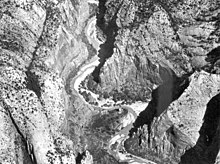
Horseshoe Bend is a horseshoe-shaped incised meander of the Colorado River located near the town of Page, Arizona, United States. It is also referred to as the "east rim of the Grand Canyon."

In geomorphology a river is said to be rejuvenated when it is eroding the landscape in response to a lowering of its base level. The process is often a result of a sudden fall in sea level or the rise of land. The disturbance enables a rise in the river's gravitational potential energy change per unit distance, increasing its riverbed erosion rate. The erosion occurs as a result of the river adjusting to its new base level.

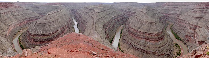
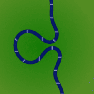
A meander is one of a series of regular sinuous curves in the channel of a river or other watercourse. It is produced as a watercourse erodes the sediments of an outer, concave bank and deposits sediments on an inner, convex bank which is typically a point bar. The result of this coupled erosion and sedimentation is the formation of a sinuous course as the channel migrates back and forth across the axis of a floodplain.
In geomorphology, a knickpoint or nickpoint is part of a river or channel where there is a sharp change in channel bed slope, such as a waterfall or lake. Knickpoints reflect different conditions and processes on the river, often caused by previous erosion due to glaciation or variance in lithology. In the cycle of erosion model, knickpoints advance one cycle upstream, or inland, replacing an older cycle. A knickpoint that occurs at the head of a channel is called a headcut. Headcuts resulting in headward erosion are hallmarks of unstable expanding drainage features such as actively eroding gullies.

Downcutting, also called erosional downcutting, downward erosion or vertical erosion, is a geological process by hydraulic action that deepens the channel of a stream or valley by removing material from the stream's bed or the valley's floor. The speed of downcutting depends on the stream's base level, the lowest point to which the stream can erode. Sea level is the ultimate base level, but many streams have a higher "temporary" base level because they empty into another body of water that is above sea level or encounter bedrock that resists erosion. A concurrent process called lateral erosion refers to the widening of a stream channel or valley. When a stream is high above its base level, downcutting will take place faster than lateral erosion; but as the level of the stream approaches its base level, the rate of lateral erosion increases. This is why streams in mountainous areas tend to be narrow and swift, forming V-shaped valleys, while streams in lowland areas tend to be wide and slow-moving, with valleys that are correspondingly wide and flat-bottomed. The term gradient refers to the elevation of a stream relative to its base level. The steeper the gradient, the faster the stream flows. Sometimes geological uplift will increase the gradient of a stream even while the stream downcuts toward its base level, a process called "rejuvenation." This happened in the case of the Colorado River in the western United States, resulting in the process that created the Grand Canyon.

In the Earth sciences, a palaeochannel, also spelled paleochannel, is a significant length of a river or stream channel which no longer conveys fluvial discharge as part of an active fluvial system. The term palaeochannel is derived from the combination of two words, palaeo or old, and channel; i.e., a palaeochannel is an old channel. Palaeochannels may be preserved either as abandoned surface channels on the surface of river floodplains and terraces or infilled and partially or fully buried by younger sediments. The fill of a palaeochannel and its enclosing sedimentary deposits may consist of unconsolidated, semi-consolidated, or well-cemented sedimentary strata depending on the action of tectonics and diagenesis during their geologic history after deposition. The abandonment of an active fluvial channel and the resulting formation of a palaeochannel can be the result of tectonic processes, geomorphologic processes, anthropogenic activities, climatic changes, or a variable and interrelated combination of these factors.

A drop structure, also known as a grade control, sill, or weir, is a manmade structure, typically small and built on minor streams, or as part of a dam's spillway, to pass water to a lower elevation while controlling the energy and velocity of the water as it passes over. Unlike most dams, drop structures are usually not built for water impoundment, diversion, or raising the water level. Mostly built on watercourses with steep gradients, they serve other purposes such as water oxygenation and erosion prevention.

The interaction between erosion and tectonics has been a topic of debate since the early 1990s. While the tectonic effects on surface processes such as erosion have long been recognized, the opposite has only recently been addressed. The primary questions surrounding this topic are what types of interactions exist between erosion and tectonics and what are the implications of these interactions. While this is still a matter of debate, one thing is clear, Earth's landscape is a product of two factors: tectonics, which can create topography and maintain relief through surface and rock uplift, and climate, which mediates the erosional processes that wear away upland areas over time. The interaction of these processes can form, modify, or destroy geomorphic features on Earth's surface.

A river is a natural flowing watercourse, usually a freshwater stream, flowing on the Earth's land surface or inside caves towards another waterbody at a lower elevation, such as an ocean, sea, bay, lake, wetland, or another river. In some cases, a river flows into the ground or becomes dry at the end of its course without reaching another body of water. Small rivers can be referred to by names such as creek, brook, and rivulet. There are no official definitions for these various generic terms for a watercourse as applied to geographic features, although in some countries or communities, a stream is customarily referred to by one of these names as determined by its size. Many names for small rivers are specific to geographic location; examples are "run" in some parts of the United States, "burn" in Scotland and Northeast England, and "beck" in Northern England. Sometimes a river is defined as being larger than a creek, but not always; the language is vague.

In sedimentary geology and fluvial geomorphology, avulsion is the rapid abandonment of a river channel and the formation of a new river channel. Avulsions occur as a result of channel slopes that are much less steep than the slope that the river could travel if it took a new course.

An alluvial river is one in which the bed and banks are made up of mobile sediment and/or soil. Alluvial rivers are self-formed, meaning that their channels are shaped by the magnitude and frequency of the floods that they experience, and the ability of these floods to erode, deposit, and transport sediment. For this reason, alluvial rivers can assume a number of forms based on the properties of their banks; the flows they experience; the local riparian ecology; and the amount, size, and type of sediment that they carry.

A bedrock river is a river that has little to no alluvium mantling the bedrock over which it flows. However, most bedrock rivers are not pure forms; they are a combination of a bedrock channel and an alluvial channel. The way one can distinguish between bedrock rivers and alluvial rivers is through the extent of sediment cover.
Channel patterns are found in rivers, streams, and other bodies of water that transport water from one place to another. Systems of branching river channels dissect most of the sub-aerial landscape, each in a valley proportioned to its size. Whether formed by chance or necessity, by headward erosion or downslope convergence, whether inherited or newly formed. Depending on different geological factors such as weathering, erosion, depositional environment, and sediment type, different types of channel patterns can form.

Riparian-zone restoration is the ecological restoration of riparian-zonehabitats of streams, rivers, springs, lakes, floodplains, and other hydrologic ecologies. A riparian zone or riparian area is the interface between land and a river or stream. Riparian is also the proper nomenclature for one of the fifteen terrestrial biomes of the earth; the habitats of plant and animal communities along the margins and river banks are called riparian vegetation, characterized by aquatic plants and animals that favor them. Riparian zones are significant in ecology, environmental management, and civil engineering because of their role in soil conservation, their habitat biodiversity, and the influence they have on fauna and aquatic ecosystems, including grassland, woodland, wetland or sub-surface features such as water tables. In some regions the terms riparian woodland, riparian forest, riparian buffer zone, or riparian strip are used to characterize a riparian zone.
A meander cutoff is a natural form of a cutting or cut in a river occurs when a pronounced meander (hook) in a river is breached by a flow that connects the two closest parts of the hook to form a new channel, a full loop. The steeper drop in gradient (slope) causes the river flow gradually to abandon the meander which will silt up with sediment from deposition. Cutoffs are a natural part of the evolution of a meandering river. Rivers form meanders as they flow laterally downstream, see sinuosity.

Terraces can be formed in many ways and in several geologic and environmental settings. By studying the size, shape, and age of terraces, one can determine the geologic processes that formed them. When terraces have the same age and/or shape over a region, it is often indicative that a large-scale geologic or environmental mechanism is responsible. Tectonic uplift and climate change are viewed as dominant mechanisms that can shape the earth’s surface through erosion. River terraces can be influenced by one or both of these forcing mechanisms and therefore can be used to study variation in tectonics, climate, and erosion, and how these processes interact.
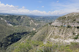
River incision is the narrow erosion caused by a river or stream that is far from its base level. River incision is common after tectonic uplift of the landscape. Incision by multiple rivers result in a dissected landscape, for example a dissected plateau. River incision is the natural process by which a river cuts downward into its bed, deepening the active channel. Though it is a natural process, it can be accelerated rapidly by human factors including land use changes such as timber harvest, mining, agriculture, and road and dam construction. The rate of incision is a function of basal shear-stress. Shear stress is increased by factors such as sediment in the water, which increase its density. Shear stress is proportional to water mass, gravity, and WSS:
The Rosgen Stream Classification is a system for natural rivers in which morphological arrangements of stream characteristics are organized into relatively homogeneous stream types. This is a widely used method for classifying streams and rivers based on common patterns of channel morphology. The specific objectives of this stream classification system are as follows: 1) predict a rivers behavior from its appearance; 2) develop specific hydrologic and sediment relationships for a given stream type and its state; 3) provide mechanisms to extrapolate site-specific data to stream reaches having similar characteristics; and 4) provide a consistent frame of reference for communicating stream morphology and condition among a variety of disciplines and interested parties. These objectives are met through Rosgen's four hierarchical levels (I-IV) of river morphology.