The Mississippi River is the primary river, and second-longest river, of the largest drainage basin in the United States. From its traditional source of Lake Itasca in northern Minnesota, it flows generally south for 2,340 miles (3,766 km) to the Mississippi River Delta in the Gulf of Mexico. With its many tributaries, the Mississippi's watershed drains all or parts of 32 U.S. states and two Canadian provinces between the Rocky and Appalachian mountains. The main stem is entirely within the United States; the total drainage basin is 1,151,000 sq mi (2,980,000 km2), of which only about one percent is in Canada. The Mississippi ranks as the thirteenth-largest river by discharge in the world. The river either borders or passes through the states of Minnesota, Wisconsin, Iowa, Illinois, Missouri, Kentucky, Tennessee, Arkansas, Mississippi, and Louisiana.

The Ohio River is a 981-mile-long (1,579 km) river in the United States. It is located at the boundary of the Midwestern and Southern United States, flowing in a southwesterly direction from western Pennsylvania to its mouth on the Mississippi River at the southern tip of Illinois. It is the third largest river by discharge volume in the United States and the largest tributary by volume of the north-south flowing Mississippi River, which divides the eastern from western United States. It is also the 6th oldest river on the North American continent. The river flows through or along the border of six states, and its drainage basin includes parts of 14 states. Through its largest tributary, the Tennessee River, the basin includes several states of the southeastern U.S. It is the source of drinking water for five million people.

The Illinois and Michigan Canal connected the Great Lakes to the Mississippi River and the Gulf of Mexico. In Illinois, it ran 96 miles (154 km) from the Chicago River in Bridgeport, Chicago to the Illinois River at LaSalle-Peru. The canal crossed the Chicago Portage, and helped establish Chicago as the transportation hub of the United States, before the railroad era. It was opened in 1848. Its function was partially replaced by the wider and deeper Chicago Sanitary and Ship Canal in 1900, and it ceased transportation operations with the completion of the Illinois Waterway in 1933.

Alton is a city on the Mississippi River in Madison County, Illinois, United States, about 18 miles (29 km) north of St. Louis, Missouri. The population was 25,676 at the 2020 census. It is a part of the River Bend area in the Metro-East region of the Greater St. Louis metropolitan area. It is famous for its limestone bluffs along the river north of the city, as the former location of the state penitentiary, and for its role preceding and during the American Civil War. It was the site of the last Abraham Lincoln and Stephen Douglas debate in October 1858. The former state penitentiary in Alton was used during the Civil War to hold up to 12,000 Confederate prisoners of war. Also, the tallest man in history, Robert Wadlow, was born and raised in Alton.
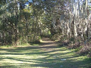
The Marjorie Harris Carr Cross Florida Greenway is a protected green belt corridor, more than one and a half miles (2.4 km) wide in places, that was the former route of the proposed Cross Florida Barge Canal. It is named for the leader of opposition to the Cross Florida Barge Canal, Marjorie Harris Carr, and was originally a U.S. Army Corps of Engineers canal project to connect the Gulf of Mexico and the Atlantic Ocean across Florida for barge traffic. Two sections were built, but the project was ultimately cancelled because of local opposition related to environmental concerns, including protecting the state's water supply and conservation of the Ocklawaha River Valley ecosystem, as well as national opposition for the costs being perceived as "government waste" with "limited national value." The greenway is part of the system of Florida State Parks, including the Santos Trail System, and is managed by the Florida Department of Environmental Protection.

The Hennepin Canal State Trail, also just called the Hennepin Canal, is an abandoned waterway in northwest Illinois, between the Mississippi River at Rock Island and the Illinois River near Hennepin. The entire canal is listed on the National Register of Historic Places.

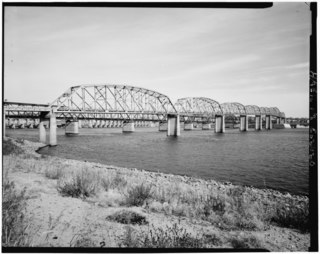
The McKinley Bridge is a steel truss bridge across the Mississippi River. It connects northern portions of the city of St. Louis, Missouri with Venice, Illinois. It opened in 1910 and was taken out of service on October 30, 2001. The bridge was reopened for pedestrian and bicyclists on November 17, 2007 with a grand re-opening celebration. Since December 2007, McKinley has been open to vehicular traffic as well. It is accessible from Illinois Route 3 in Illinois and from the intersection of Salisbury and North 9th Street in the city of St. Louis. The bridge carried both railroad and vehicular traffic across the Mississippi River for decades. By 1978, the railroad line over the span was closed, and an additional set of lanes was opened for vehicles in the inner roadway.
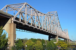
The Martin Luther King Bridge in St. Louis, Missouri, is a cantilever truss bridge of about 4,000 feet (1,200 m) in total length across the Mississippi River, connecting St. Louis with East St. Louis, Illinois. Opened in 1951, the bridge serves as traffic relief connecting the concurrent freeways of Interstate 55, Interstate 64, and U.S. Route 40 with the downtown streets of St. Louis. It was renamed for King in 1968 after the national civil rights leader was assassinated that year.

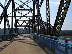
The New Chain of Rocks Bridge is a pair of bridges across the Mississippi River on the north edge of St. Louis, Missouri. It was constructed in 1966 to bypass the Chain of Rocks Bridge immediately to the south. It originally carried traffic for Bypass US 66 and currently carries traffic for Interstate 270. The bridge opened to traffic on September 2, 1966.
The Upper Mississippi River is today the portion of the Mississippi River upstream of St. Louis, Missouri, United States, at the confluence of its main tributary, the Missouri River. Historically, it may refer to the area above the Arkansas Post, above the confluence of Ohio River, or above Cape Girardeau.

Transportation in Greater St. Louis, Missouri includes road, rail, ship, and air transportation modes connecting the bi-state St. Louis metropolitan area with surrounding communities throughout the Midwest, national transportation networks, and international locations. The Greater St. Louis region also supports a multi-modal transportation network that includes bus, paratransit, and light rail service in addition to shared-use paths, bike lanes and greenways.
The Old Clark Bridge was a bridge that carried U.S. Route 67 across the Mississippi River between West Alton, Missouri and Alton, Illinois. It was constructed beginning in 1927, was replaced by the Clark Bridge and was demolished in 1994. The bridge was initially a toll bridge.

Melvin Price Locks and Dam is a dam and two locks at river mile 200.78 on the Upper Mississippi River, about 17 miles (27 km) north of Saint Louis, Missouri. The collocated National Great Rivers Museum, explains the structure and its engineering.

Lock and Dam No. 19 is a lock and dam located on the Upper Mississippi River near Keokuk, Iowa. In 1978, the Keokuk Lock and Dam was listed in the National Register of Historic Places, #78001234. In 2004, the facility was listed in the National Register of Historic Places as Lock and Dam No. 19 Historic District, #04000179 covering 1,605 acres (650 ha), 7 buildings, 12 structures, 1 object. The lock is owned and operated by the U.S. Army Corps of Engineers. The dam is owned and operated by Ameren Missouri.

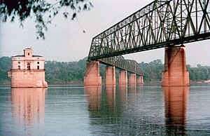
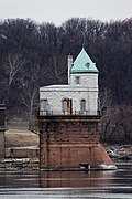
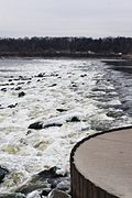
Chain of Rocks Lock and Dam, also known as Locks No. 27, is a lock situated at the southern end of Chouteau Island near St. Louis, Missouri on the Upper Mississippi River. Its associated dam is just downstream of the Chain of Rocks Bridge, and the lock is located over 3 miles (4.8 km) southeast on the Chain of Rocks canal. The canal and locks allow river traffic to bypass a portion of the river that is unnavigable in low water due to an anticlinal exposure of bedrock in the river—a "chain of rocks".

Chouteau Island, situated approximately eight miles (13 km) due north of the Gateway Arch in St. Louis, Missouri, and approximately one mile (1.6 km) south of the confluence of the Missouri River and Mississippi River, is one of a cluster of three islands: Chouteau Island, Gabaret Island, and Mosenthein Island. The three, with a combined area of approximately 5,500 acres (20 km2), are located in Madison County, Illinois.
In 1997, with support from The McKnight Foundation, a group of non-profit organizations led by Trailnet formed a partnership to plan and implement the Confluence Greenway. The Confluence Greenway was planned as a 200-square-mile (520 km2) system of parks, conservation and recreation areas located in the St. Louis, Missouri metropolitan area. Various parks, trails, and attractions are located along forty miles of both the Missouri and Illinois banks of the Mississippi River and Missouri River.
The Confluence Trail, part of the Madison County, Illinois Transit (MCT) bikeways network, is a 20.5 miles (33.0 km) bike trail between Granite City and Alton, Illinois's Russell Commons Park. The majority of the trail is paved asphalt on top of the Mississippi River levee system. The trail is part of the St. Louis metro area's Confluence Greenway.

The Great Rivers Greenway District is a public agency created in 2000 to develop a regional network of greenways. Great Rivers Greenway engages citizens and community partners to plan, build and care for the greenways. In its first 20 years the agency built more than 128 miles of greenways connecting parks, rivers, schools, neighborhoods, business districts and transit.

U.S. Route 67 is the portion of a north-south highway in Missouri that starts at the Arkansas state line south of Neelyville and ends at the Illinois state line northeast of West Alton.