
St. Louis is an independent city in the U.S. state of Missouri. It is located near the confluence of the Mississippi and the Missouri rivers. In 2020, the city proper had a population of 301,578, while its metropolitan area, which extends into Illinois, had an estimated population of over 2.8 million. It is the largest metropolitan area in Missouri and the second-largest in Illinois. The city's combined statistical area is the 20th-largest in the United States.
The Avenue of the Saints is a 563-mile-long (906 km) highway in the Midwestern United States that connects St. Louis, Missouri, and St. Paul, Minnesota.
St. Charles Rock Road is the current name of what was the first road to traverse present-day St. Louis County, Missouri between St. Louis and St. Charles. For most of its length it is also known as Route 180.

Route 364, known locally as the Page Extension, the Page Avenue Freeway, the Page Expressway, or simply the Extension, is a freeway that connects St. Louis County in Maryland Heights with St. Charles County in Lake St. Louis via the Veterans Memorial Bridge over the Missouri River. The highway is a designated auxiliary state route of I-64.

Interstate 270 (I-270) makes up a large portion of the outer belt freeway in Greater St. Louis. The counterclockwise terminus of I-270 is at the junction with I-55 and I-255 in Mehlville, Missouri; the clockwise terminus of the freeway is at the junction with I-55 and I-70 north of Troy, Illinois. The entire stretch of I-270 is 50.59 miles (81.42 km).
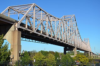
The Martin Luther King Bridge in St. Louis, Missouri, is a cantilever truss bridge of about 4,000 feet (1,200 m) in total length across the Mississippi River, connecting St. Louis with East St. Louis, Illinois. Opened in 1951, the bridge serves as traffic relief connecting the concurrent freeways of Interstate 55, Interstate 64, and U.S. Route 40 with the downtown streets of St. Louis. It was renamed for King in 1968 after the national civil rights leader was assassinated that year.

Forgottonia, also spelled Forgotonia, is the name given to a 16-county region in Western Illinois in the late 1960s and early 1970s. This geographic region forms the distinctive western bulge of Illinois that is roughly equivalent to "The Tract", the Illinois portion of the Military Tract of 1812, along and west of the Fourth Principal Meridian. Since this wedge-shaped region lies between the Illinois and Mississippi rivers, it has historically been isolated from the eastern portion of Central Illinois.
The Chester Bridge is a continuous truss bridge connecting Missouri's Route 51 with Illinois Route 150 across the Mississippi River between Perryville, Missouri and Chester, Illinois. It is the only motor-traffic bridge spanning the Mississippi River between St. Louis and Cape Girardeau, Missouri.

The New Chain of Rocks Bridge is a pair of bridges across the Mississippi River on the north edge of St. Louis, Missouri. It was constructed in 1966 to bypass the Chain of Rocks Bridge immediately to the south. It originally carried traffic for Bypass US 66 and currently carries traffic for Interstate 270. The bridge opened to traffic on September 2, 1966.

The Discovery Bridge is a pair of truss bridges carrying Missouri Route 370 across the Missouri River between St. Louis County and St. Charles County, in the U.S. state of Missouri. The bridge was built between 1989 and 1992. Massman Construction built the river substructure and erected the steel girders. The St Charles pier is founded on rock. Piers 2-4 are supported by 6' diameter drilled shafts. Pier 5 on the St Louis County side is founded on Hp14-117 piling. The two trusses were fabricated by Stupp Brothers and erected approximately 500' downstream on falsework and floated into their final position after their transfer to barges. The land approaches substructure and concrete girders were built by Fred Weber. The entire deck was built by Kozney Wagner.
The Blanchette Memorial Bridge carries Interstate 70 across the Missouri River between St. Louis County and St. Charles County, Missouri. It is formed from a pair of twin cantilever bridges and opened in 1959, with a second bridge opened in 1979. At the bridge's crossing, the Missouri River reaches an average depth of 45 feet. It is the area's busiest bridge, handling an average of 165,000 vehicle transits per day. Construction of the first interstate highway project started west of the bridge's present location.
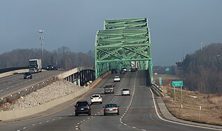
The Daniel Boone Bridge is the name for two bridges carrying Interstate 64, U.S. Route 40, U.S. Route 61 and the Avenue of the Saints across the Missouri River between St. Louis County and St. Charles County, Missouri. The older bridge, which carries westbound traffic, is a continuous truss bridge, while the newer bridge, which carries eastbound traffic, is a deck girder bridge.

Transportation in Greater St. Louis, Missouri includes road, rail, ship, and air transportation modes connecting the bi-state St. Louis metropolitan area with surrounding communities throughout the Midwest, national transportation networks, and international locations. The Greater St. Louis region also supports a multi-modal transportation network that includes bus, paratransit, and light rail service in addition to shared-use paths, bike lanes and greenways.

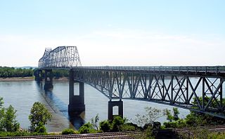
The Bellefontaine Bridge is a four-span truss railroad bridge over the Missouri River between St. Charles County, Missouri, and St. Louis County, Missouri. It has four 440-foot (130 m) spans. Construction started on July 4, 1892, and the bridge opened on December 27, 1893.
The Washington Bridge is a concrete girder bridge that carries Route 47 over the Missouri River in Washington, Missouri. It replaces a cantilever truss bridge of the same name that passed between Franklin County, Missouri and Warren County, Missouri. It has also been known as the Route 47 Missouri River Bridge.

Interstate 70 (I-70) in the US state of Missouri is generally parallel to the Missouri River. This section of the transcontinental interstate begins at the Kansas state line on the Lewis and Clark Viaduct, running concurrently with U.S. Route 24 (US 24), US 40 and US 169, and the east end is on the Stan Musial Veterans Memorial Bridge in St. Louis.

Interstate 64 (I-64) passes through the Greater St. Louis area in the US state of Missouri. The entire route is concurrent with U.S. Route 40 (US 40). Because the road was a main thoroughfare in the St. Louis area before the development of the Interstate Highway System, it is not uncommon for locals to refer to the stretch of highway as "Highway 40" rather than "I-64". On December 6, 2009, the portion of the highway running through the city of St. Louis was named the Jack Buck Memorial Highway in honor of the late sportscaster.

Interstate 44 (I-44) in the US state of Missouri runs northeast from the Oklahoma state line near Joplin to I-70 in Downtown St. Louis. It runs for about 293 miles (472 km) in the state, and is the longest Interstate Highway in the state.

U.S. Route 67 is the portion of a north-south highway in Missouri that starts at the Arkansas state line south of Neelyville and ends at the Illinois state line northeast of West Alton.
U.S. Route 67 (US 67) is a component of the United States Numbered Highway System that connects Presidio, Texas, to Sabula, Iowa. In Illinois, it serves the western region of the state known as Forgottonia, named for the lack of regional transportation and infrastructure projects. The highway begins its path through the state by crossing the Clark Bridge over the Mississippi River from Missouri at Alton and heads northward through Jerseyville and Jacksonville before it crosses the Illinois River at Beardstown. The northern half of the route serves Macomb and Monmouth before it enters the Quad Cities. It leaves the state at Rock Island by crossing the Rock Island Centennial Bridge over the Mississippi River into Davenport, Iowa.

