The Eads Bridge is a combined road and railway bridge over the Mississippi River connecting the cities of St. Louis, Missouri and East St. Louis, Illinois. It is located on the St. Louis riverfront between Laclede's Landing, to the north, and the grounds of the Gateway Arch, to the south. The bridge is named for its designer and builder, James Buchanan Eads. Work on the bridge began in 1867, and it was completed in 1874. The Eads Bridge was the first bridge across the Mississippi south of the Missouri River. Earlier bridges were located north of the Missouri, where the Mississippi is smaller. None of the earlier bridges survive, which means that the Eads Bridge is also the oldest bridge on the river.

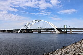
The Stan Musial Veterans Memorial Bridge is a bridge across the Mississippi River in the United States between St. Clair County, Illinois, and the city of St. Louis, Missouri. Built between April 19, 2010, and July 2013, the bridge opened on February 9, 2014. The cable-stayed bridge has a main span of 1,500 feet (457 m).

Interstate 255 (I-255) is a bypass route of I-55 in Greater St. Louis. Along with I-270, it forms a loop around the central portion of the bi-state metro area; a majority of I-255 is located on the Illinois half. It shares its southern terminus with I-270 at the junction with I-55; I-270 and I-255 go to the west and east, respectively. U.S. Route 50 (US 50) joins I-255 at Lemay Ferry Road. It crosses the Mississippi River on the Jefferson Barracks Bridge, enters Illinois, and then turns northeast. There is a junction with I-64, where US 50 breaks off and goes east, and then further north there is a junction with I-55 again, I-70, and US 40, all of which are all cosigned together. The next junction is another one with I-270, which is the northern terminus of I-255. After that, the limited-access freeway continues on as Illinois Route 255 (IL 255). I-255 is 30.82 miles (49.60 km) in length.

The old Chain of Rocks Bridge spans the Mississippi River on the north edge of St. Louis, Missouri. The eastern end of the bridge is on Chouteau Island, while the western end is on the Missouri shoreline. Its most notable feature is a 22-degree bend occurring at the middle of the crossing.
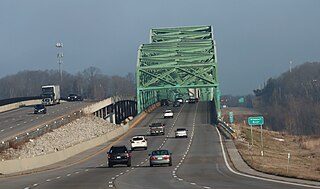
The Interstate 74 Bridge, officially known as the Iowa-Illinois Memorial Bridge, and often called The Twin Bridges, or the I-74 Bridge, are basket-handle, through arch twin bridges that carry Interstate 74 across the Mississippi River and connect Bettendorf, Iowa and Moline, Illinois. It is located near the geographic center of the Quad Cities.
Illinois Route 3 (IL 3) is a 187.44-mile-long (301.66 km) major north–south arterial state highway in southwestern Illinois. It has its southern terminus at Cairo Junction at the intersection of U.S. Route 51 (US 51) and Illinois Route 37, and its northern terminus in Grafton at IL 100.

Interstate 270 (I-270) makes up a large portion of the outer belt freeway in Greater St. Louis. The counterclockwise terminus of I-270 is at the junction with I-55 and I-255 in Mehlville, Missouri; the clockwise terminus of the freeway is at the junction with I-55 and I-70 north of Troy, Illinois. The entire stretch of I-270 is 50.59 miles (81.42 km).

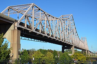
The Congressman William L. Clay Sr. Bridge, formerly known as the Bernard F. Dickmann Bridge and popularly as the Poplar Street Bridge or PSB, completed in 1967, is a 647-foot-long (197 m) deck girder bridge across the Mississippi River between St. Louis, Missouri, and East St. Louis, Illinois. The bridge arrives on the Missouri shore line just south of the Gateway Arch.

The Huey P. Long Bridge, located in Jefferson Parish, Louisiana, is a cantilevered steel through-truss bridge that carries a two-track railroad line over the Mississippi River at mile 106.1, with three lanes of US 90 on each side of the central tracks. It is several kilometers upriver from the city of New Orleans. The East Bank entrance is at Elmwood, Louisiana, and the West Bank at Bridge City.
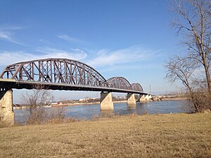
The Martin Luther King Bridge in St. Louis, Missouri, is a cantilever truss bridge of about 4,000 feet (1,200 m) in total length across the Mississippi River, connecting St. Louis with East St. Louis, Illinois. Opened in 1951, the bridge serves as traffic relief connecting the concurrent freeways of Interstate 55, Interstate 64, and U.S. Route 40 with the downtown streets of St. Louis. It was renamed for King in 1968 after the national civil rights leader was assassinated that year.

The Memphis & Arkansas Bridge, also known as the Memphis–Arkansas Bridge or inaccurately as the Memphis–Arkansas Memorial Bridge, is a cantilevered through truss bridge carrying Interstate 55 across the Mississippi River between West Memphis, Arkansas and Memphis, Tennessee. Memphians refer to this bridge as the "Old Bridge" to distinguish it from the "New Bridge", or Hernando de Soto Bridge, upstream.

The New Chain of Rocks Bridge is a pair of bridges across the Mississippi River on the north edge of St. Louis, Missouri. It was constructed in 1966 to bypass the Chain of Rocks Bridge immediately to the south. It originally carried traffic for Bypass US 66 and currently carries traffic for Interstate 270. The bridge opened to traffic on September 2, 1966.

Illinois Route 100 (IL-100) is a 159.09-mile-long (256.03 km) state highway in the southwest Illinois. It generally parallels the Illinois River. Starting in downtown Alton, it trends northward to Buckheart Township near Canton. It makes up much of the Illinois River Road, a U.S. National Scenic Byway.

The Government Bridge or Arsenal Bridge spans the Mississippi River, connecting Rock Island, Illinois and Davenport, Iowa. The Iowa Interstate Railroad uses the upper deck of the bridge for its ex-Chicago and Rock Island Railroad route between Council Bluffs, Iowa and Chicago, Illinois. The lower deck carries automobile traffic between the two cities. It is located near Upper Mississippi Mile Marker 483, adjacent to the Mississippi River Lock and Dam No. 15. The current structure is the fourth at this location. The bridges all were built with a swing section to accommodate traffic navigating the river.
The Daniel Boone Bridge is the name for two bridges carrying Interstate 64, U.S. Route 40 and U.S. Route 61 across the Missouri River between St. Louis County and St. Charles County, Missouri. The older bridge, which carries westbound traffic, is a continuous truss bridge, while the newer bridge, which carries eastbound traffic, is a deck girder bridge.
Interstate 74 (I-74) in the US state of Illinois is a major northwest–southeast Interstate Highway that runs across the central portion of the state. It runs from the Iowa state line at the Mississippi River near the city of Rock Island and runs southeast to the Indiana state line east of Danville, a distance of 220.34 miles (354.60 km). The highway runs through the major cities of Champaign, Bloomington, Peoria, and Moline.

In the U.S. state of Illinois, U.S. Route 67 (US 67) is a north–south highway through the western portions of the state. It runs from the Clark Bridge in Alton north to the Rock Island Centennial Bridge in Rock Island. It is the most direct route between St. Louis and the Quad Cities. This is a distance of 213.99 miles (344.38 km).

Interstate 70 (I-70) in the US state of Missouri is generally parallel to the Missouri River. This section of the transcontinental Interstate begins at the Kansas state line on the Lewis and Clark Viaduct, running concurrently with U.S. Route 24 (US 24), US 40, and US 169, and the east end is on the Stan Musial Veterans Memorial Bridge in St. Louis.

The Benjamin Franklin Bridge, originally named the Delaware River Bridge and known locally as the Ben Franklin Bridge, is a suspension bridge across the Delaware River connecting Philadelphia, Pennsylvania, and Camden, New Jersey. Owned and operated by the Delaware River Port Authority, it is one of four primary vehicular bridges between Philadelphia and southern New Jersey, along with the Betsy Ross, Walt Whitman, and Tacony-Palmyra bridges. It carries Interstate 676/U.S. Route 30, pedestrians/cyclists, and the PATCO Speedline.