The Great Rivers Greenway District

Last updated
Great Rivers Greenway
FormationNovember 2000
(24 years ago)
Legal statusMissouri Political Subdivision
PurposeDevelop a regional network of greenways
Headquarters3745 Foundry Way, Suite 253
Location
LeaderSusan Trautman, CEO
Main organ
Metropolitan Park and Recreation District, doing business as Great Rivers Greenway
Budget$25.5 million (2021)
Website greatriversgreenway.org
The rivers around St. Louis St Louis Rivers.png
The rivers around St. Louis

The Great Rivers Greenway District is a public agency in the state of Missouri that works to develop a regional network of greenways, parks, and trails in the St. Louis metropolitan area. [1] The agency engages citizens and community partners to plan, build, and care for the greenways. [2]

Contents

History

In 1996, a nonprofit organization called St. Louis 2004 was created with the aim of bringing about a renaissance in the region by 2004. It developed a list of 11 priorities, including developing a regional network of greenways. [1]

In 2000, organization president Peter Sortino led a successful drive to place a proposition on local ballots to create a one-tenth-of-one-cent sales tax to support greenway development. [3] In November of that year, voters in the City of St. Louis, St. Louis County, and St. Charles County approved Proposition C, also dubbed the Clean Water, Safe Parks and Community Trails Initiative. The tax enabled the creation of The Great Rivers Greenway District. [4]

The agency's distribution of funds is governed by a board of directors whose members are appointed by the chief executives of the city and two counties. [5] A chief executive officer and staff develop the River Ring, working with local, county, and state agencies and private and non-profit agencies throughout the St. Louis region.

In 2003, Great Rivers Greenway published "Building the River Ring: A Citizen-Driven Regional Plan", developed with advice from citizens, local governments, private companies, non-profit organizations and advocacy groups. The plan proposed to create the River Ring, a system of more than 40 greenways, parks, and trails comprising over 600 miles in St. Louis City, St. Louis County, and St. Charles County. The system will connect with trails developed by the Metro East Park and Recreation District of St. Clair and Madison Counties in Illinois. [6] The concept was designed to raise awareness of the natural beauty found in the region's many rivers and streams and to reconnect residents to the city's primary natural feature: the confluence of the Mississippi and Missouri rivers.

In 2011 and 2016, Great Rivers Greenway engages citizens, civic leaders and partners to update and republish the Citizen-Driven Regional Plan. [7] Pursuant to the 2016 update, a Great Rivers Greenway Foundation was formed to seek private funding for greenway projects. [8]

By 2020, the agency had built more than 128 miles of greenways connecting parks, rivers, schools, neighborhoods, business districts and transit. [9] The agency began surveying citizens about priorities to build and care for the greenways to inform the next update to the plan. [10]

Greenways

Greenways within the district:

Signage near a completed portion of the Brickline Greenway along Market Street in 2023 Brickline Signage.png
Signage near a completed portion of the Brickline Greenway along Market Street in 2023

CityArchRiver Project

In 2007, four decades after completion of the Gateway Arch, the site remained an island, severed from the rest of the city by busy highways and disconnected from the Mississippi River. Walter Metcalfe, an attorney and civic leader in St. Louis, led the formation of CityArchRiver2015 Foundation in 2009 to transform the St. Louis Riverfront and Arch grounds. [34] Michael Van Valkenburgh Associates of New York won an international competition to redesign the Arch grounds in 2010. [35] The project received $20 million in capital funding in 2011 from the U.S. Department of Transportation, a $25 million matching grant from the Missouri Department of Transportation and $10 million in private donations raised by CityArchRiver. With a total project cost of $380 million, more funding was needed. [36]

Great Rivers Greenway joined the effort in 2012, becoming part of a public-private partnership with the CityArchRiver2015 Foundation, National Park Service, Missouri Department of Transportation, Bi-State Development, and Jefferson National Parks Association. The partners planned a ballot issue known as Proposition P to generate sales tax revenue for the CityArchRiver project and other park improvements. [37]

In April 2013 voters in the City of St. Louis and St. Louis County approved Proposition P: The Safe and Accessible Arch and Public Parks Initiative. The proposition authorized a 3/16th-cent sales tax to fund the CityArchRiver project and accelerate local park and greenway construction. The tax was projected to generate $780 million over the next 20 years, with 60 percent going to Great Rivers Greenway and 40 percent going to support local parks in St. Louis City and County. Half of the Great Rivers Greenway revenue supported the CityArchRiver project and the other half would be used to accelerate greenway construction. [38] Great Rivers Greenway stewarded $85 million in Proposition P funds to complete several major projects over the next five years: [39]

CityArchRiver Foundation changed its name to the Gateway Arch Park Foundation in 2017. [47] The Foundation raised $250 million in private funds for the project. [41]

Related Research Articles

<span class="mw-page-title-main">St. Louis</span> Independent city in Missouri, United States

St. Louis is an independent city in the U.S. state of Missouri. It is located near the confluence of the Mississippi and the Missouri rivers. In 2020, the city proper had a population of 301,578, while its metropolitan area, which extends into Illinois, had an estimated population of over 2.8 million. It is the largest metropolitan area in Missouri and the second-largest in Illinois. The city's combined statistical area is the 20th-largest in the United States.

<span class="mw-page-title-main">Gateway Arch National Park</span> National park in St. Louis, Missouri, U.S.

Gateway Arch National Park is a national park of the United States located in St. Louis, Missouri, near the starting point of the Lewis and Clark Expedition.

<span class="mw-page-title-main">Gateway Arch</span> U.S. National Historic Landmark in St. Louis, Missouri

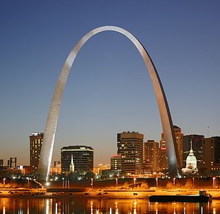
The Gateway Arch is a 630-foot-tall (192 m) monument in St. Louis, Missouri, United States. Clad in stainless steel and built in the form of a weighted catenary arch, it is the world's tallest arch and Missouri's tallest accessible structure. Some sources consider it the tallest human-made monument in the Western Hemisphere. Built as a monument to the westward expansion of the United States and officially dedicated to "the American people", the Arch, commonly referred to as "The Gateway to the West", is a National Historic Landmark in Gateway Arch National Park and has become a popular tourist destination, as well as an internationally recognized symbol of St. Louis.

<span class="mw-page-title-main">St. Louis County, Missouri</span> County in Missouri, United States

St. Louis County is located in eastern Missouri. It is bounded by the City of St. Louis and the Mississippi River to the east, the Missouri River to the north, and the Meramec River to the south. At the 2020 census, the total population was 1,004,125, making it the most populous county in Missouri. Its county seat is Clayton. The county is included in the St. Louis, MO–IL metropolitan statistical area.

<span class="mw-page-title-main">Valley Park, Missouri</span> City in Missouri, United States

Valley Park is a city in St. Louis County, Missouri, United States. The population was 6,885 at the 2020 census.

<span class="mw-page-title-main">Meramec River</span> River in the American state of Missouri

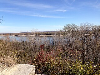
The Meramec River, sometimes spelled Maramec River, is one of the longest free-flowing waterways in the U.S. state of Missouri, draining 3,980 square miles (10,300 km2) while wandering 218 miles (351 km) from headwaters southeast of Salem to where it empties into the Mississippi River near St. Louis at Arnold and Oakville. The Meramec watershed covers six Missouri Ozark Highland counties—Dent, Phelps, Crawford, Franklin, Jefferson, and St. Louis—and portions of eight others—Maries, Gasconade, Iron, Washington, Reynolds, St. Francois, Ste. Genevieve, and Texas. Between its source and its mouth, it falls 1,025 feet (312 m). Year-round navigability begins above Maramec Spring, just south of St. James. The Meramec's size increases at the confluence of the Dry Fork, and its navigability continues until the river enters the Mississippi at Arnold, Missouri.

<span class="mw-page-title-main">Greater St. Louis</span> Combined Statistical Area in the United States

Greater St. Louis is the 23rd-largest metropolitan statistical area (MSA) in the United States, the largest in Missouri, and the second-largest in Illinois. Its core city—St. Louis, Missouri—sits in the geographic center of the metro area, on the west bank of the Mississippi River. The river bisects the metro area geographically between Illinois and Missouri, although the latter portion is much more populous. The MSA includes St. Louis County, which is independent of the City of St. Louis; their two populations are generally tabulated separately.

<span class="mw-page-title-main">River des Peres</span> River in St. Louis, Missouri

The River des Peres is a 9.3-mile (15.0 km) metropolitan river in St. Louis, Missouri. It is the backbone of sanitary and storm water systems in the city of St. Louis and portions of St. Louis County. Its largest tributaries are Deer Creek and Gravois Creek. At St. Louis, the river has a mean annual discharge of 79 cubic feet per second.

<span class="mw-page-title-main">Chain of Rocks Bridge</span> Footbridge on the Mississippi River in St. Louis, Missouri

The old Chain of Rocks Bridge spans the Mississippi River on the north edge of St. Louis, Missouri, United States. The eastern end of the bridge is on Chouteau Island, while the western end is on the Missouri shoreline. Its most notable feature is a 22-degree bend occurring at the middle of the crossing, which was found to be necessary during construction due to both the presence of a water intake and the inability of parts of the bedrock of the river to carry the weight of the bridge.

Edward "Ted" and Pat Jones-Confluence Point State Park is a public recreation area located on the north side of the Missouri River at its confluence with the Mississippi River in St. Charles County, Missouri. The state park encompasses 1,121 acres (454 ha) of shoreline and bottomland and is managed by the Missouri Department of Natural Resources, which "plans to restore a natural floodplain reminiscent of what Lewis and Clark might have seen along the lower Missouri River." The park is part of the Mississippi Greenway and sits opposite the Columbia Bottom Conservation Area on the south bank of the Missouri River. Park trails will eventually connect with the statewide Katy Trail.

<span class="mw-page-title-main">Malcolm W. Martin Memorial Park</span> Gateway Geyser venue

Malcolm W. Martin Memorial Park is a park on the east side of the Mississippi River in East St. Louis, Illinois, directly across from the Gateway Arch and the city of St. Louis, Missouri. For 29 years, its major feature was the Gateway Geyser, a fountain that lifted water up to 630 feet (192 m), the same height as the Arch. Four smaller fountains around the Geyser represent the four rivers which converge near the two cities: The Mississippi, Missouri, Illinois, and Meramec. It was closed in 2023 due to costs of refurbishment and to prepare the park for being handed over to the National Park Service as an extension of the Gateway memorial. The park also includes an elevated viewing point overlooking the river.

<span class="mw-page-title-main">U.S. Route 66 in Missouri</span> Section of U.S. Highway in Missouri, United States

U.S. Route 66 is a former east–west United States Numbered Highway, running from Santa Monica, California to Chicago, Illinois. In Missouri, the highway ran from downtown St. Louis at the Mississippi River to the Kansas state line west of Joplin. The highway was originally Route 14 from St. Louis to Joplin and Route 1F from Joplin to Kansas. It underwent two major realignments and several lesser realignments in the cities of St. Louis, Springfield, and Joplin. Current highways covering several miles of the former highway include Route 100, Route 366, Route 266, Route 96, and Route 66. Interstate 44 (I-44) approximates much of US 66 between St. Louis and Springfield.

<span class="mw-page-title-main">Transportation in St. Louis</span>

Transportation in Greater St. Louis, Missouri includes road, rail, ship, and air transportation modes connecting the bi-state St. Louis metropolitan area with surrounding communities throughout the Midwest, national transportation networks, and international locations. The Greater St. Louis region also supports a multi-modal transportation network that includes bus, paratransit, and light rail service in addition to shared-use paths, bike lanes and greenways.

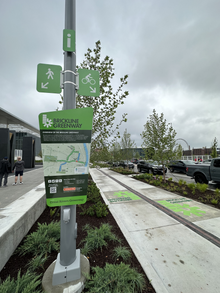
In 1997, with support from The McKnight Foundation, a group of non-profit organizations led by Trailnet formed a partnership to plan and implement the Confluence Greenway. The Confluence Greenway was planned as a 200-square-mile (520 km2) system of parks, conservation and recreation areas located in the St. Louis, Missouri metropolitan area. Various parks, trails, and attractions are located along forty miles of both the Missouri and Illinois banks of the Mississippi River and Missouri River.

<span class="mw-page-title-main">St. Louis Gateway Mall</span>

The Gateway Mall in St. Louis, Missouri is an open green space running linearly, one block wide, from the Gateway Arch at Memorial Drive to Union Station at 20th Street. Located in the city's downtown, it runs between Market Street and Chestnut Street.

<span class="mw-page-title-main">Iconography of St. Louis</span>

The Iconography of St. Louis, Missouri is strongly informed by the city's French and German heritages, physical features, and place in American history.

The streets of St. Louis, Missouri, United States, and the surrounding area of Greater St. Louis are under the jurisdiction of the City of St. Louis Street Department. According to the department's Streets Division, there are 1,000 miles (1,600 km) of streets and 600 miles (970 km) of alleys within the city.

Parks in Greater St. Louis are administered by a variety of state, county, and municipal authorities. The region also is home to Gateway Arch National Park, site of the Gateway Arch, the only National Memorial in the state of Missouri. Among the largest municipal parks is Forest Park, which is 1,293 acres (5.2 km2) and is located in the city of St. Louis, although both Greensfelder County Park and Creve Coeur Park in St. Louis County are larger, at 1,646 and 2,114 acres respectively. St. Louis County is also the location of two large state parks, Babler State Park with 3.8 square miles (9.8 km2) and Castlewood State Park with 2.8 square miles (7.3 km2). The largest state park in the region is Meramec State Park, located near Sullivan, Missouri, with 10.8 square miles (28 km2) of parkland.

<span class="mw-page-title-main">Grant's Trail</span> Mixed-use trail in Missouri, United States

Grant's Trail is a mixed-use trail in St. Louis County, Missouri, that begins at the River Des Peres Greenway at River City Boulevard and I-55 and runs northwest to Holmes Ave and I-44 in Kirkwood. The trail is 12.14 miles (19.54 km) and is part of the Gravois Greenway. It connects the Meramec River Greenway to the River des Peres Greenway.

<span class="mw-page-title-main">Cliff Cave Park</span> Public park in St. Louis County, Missouri, U.S.

Cliff Cave Park is a 525-acre public park located in St. Louis County, Missouri. The park is owned and operated by the St. Louis County Department of Parks and Recreation. It is named after Cliff Cave, a natural cave located in the park that is a historical and archaeologic site. The park contains woodlands, wetlands, and rocky hillsides and is adjacent to the Mississippi River. It has three trails: the Mississippi Trail, the Spring Valley Trail, and the River Bluff Trail. The Riverside Shelter overlooks the Mississippi River. An active train track runs through the park. Cliff Cave Park is part of the Mississippi River Greenway. The park won the "Best View of the Mississippi" award in 2009, which it was granted by The Riverfront Times.

References

  1. 1 2 "Citizen-Driven Regional Plan 2004". Great Rivers Greenway. Archived from the original on 23 September 2021. Retrieved 23 Sep 2021.
  2. "Great Rivers Greenway About Us". Great Rivers Greenway. Retrieved 23 Sep 2021.
  3. "Obituary: Peter Sortino — unsung leader of St. Louis 2004 helped keep the region green and glowing". KBIA. 2017-03-24. Retrieved 2024-12-11.
  4. "Link me to St. Louis" . Retrieved 18 Oct 2021.
  5. "What's the Great Rivers Greenway District?". St. Louis Public Radio. 2 November 2013. Archived from the original on 29 September 2021. Retrieved 29 Sep 2021.
  6. "Citizen-Driven Regional Plan 2004". Great Rivers Greenway. Archived from the original on 23 September 2021. Retrieved 29 Sep 2021.
  7. "Citizen-Driven 2011 Regional Plan Update". Great Rivers Greenway. Retrieved 29 Sep 2021.
  8. "FINAL-2016-Regional-Plan (pdf)" (PDF). Great Rivers Greenway. Retrieved 21 Sep 2021.
  9. "Envision the Next 20 Years of Greenways". Great Rivers Greenway. 2 December 2020. Retrieved 23 Sep 2021.
  10. "Great Rivers Greenway, seeing a boom in trail users during the pandemic, seeks input with survey". St. Louis Post-Dispatch. 24 November 2020. Retrieved 21 Sep 2021.
  11. "Boschert Greenway Master Plan". Great Rivers Greenway. Archived from the original on 2 October 2021. Retrieved 2 Oct 2021.
  12. "The 30 Foot Flower in the Boschert Greenway". Great Rivers Greenway. Archived from the original on 2 October 2021. Retrieved 2 Oct 2021.
  13. "The Chouteau Greenway project has a new name". St. Louis Magazine. 11 March 2020. Retrieved 2 Oct 2021.
  14. "Brickline Greenway" . Retrieved 18 Oct 2021.
  15. "The Brickline Greenway: Charting a Path towards Social Equity in St. Louis". City Parks Alliance. 16 February 2021. Archived from the original on 3 October 2021. Retrieved 2 Oct 2021.
  16. "Busch Greenway Master Plan". Great Rivers Greenway. Archived from the original on 2 October 2021. Retrieved 2 Oct 2021.
  17. "Centennial Greenway Master Plan". Great Rivers Greenway. Retrieved 2 Oct 2021.
  18. "Dardenne Greenway Master Plan". Great Rivers Greenway. Archived from the original on 2 October 2021. Retrieved 2 Oct 2021.
  19. "Deer Creek Greenway Master Plan". Great Rivers Greenway. Archived from the original on 2 October 2021. Retrieved 2 Oct 2021.
  20. "Fee Fee Greenway Master Plan". Great Rivers Greenway. Archived from the original on 2 October 2021. Retrieved 2 Oct 2021.
  21. "Grant's Trail, Missouri". Archived from the original on 29 October 2021. Retrieved 14 Oct 2021.
  22. "Gravois Greenway: Grant's Trail". Archived from the original on 22 October 2021. Retrieved 14 Oct 2021.
  23. "Maline Greenway". Archived from the original on 22 October 2021. Retrieved 14 Oct 2021.
  24. "Meramec Greenway Master Plan". Archived from the original on 15 October 2021. Retrieved 15 Oct 2021.
  25. "Mississippi Greenway Master Plan" . Retrieved 18 Oct 2021.
  26. "Chain of Rocks Bridge". Archived from the original on 23 October 2010. Retrieved 18 Oct 2021.
  27. "Trailnet's History". Archived from the original on 18 October 2021. Retrieved 18 Oct 2021.
  28. "New bicycle and pedestrian path on the Discovery Bridge opens Saturday". Archived from the original on 18 October 2021. Retrieved 18 Oct 2021.
  29. "Missouri Greenway Master Plan" . Retrieved 18 Oct 2021.
  30. "River des Peres Greenway Master Plan" . Retrieved 18 Oct 2021.
  31. "St. Vincent Greenway Master Plan". Archived from the original on 18 October 2021. Retrieved 18 Oct 2021.
  32. "Sunset Greenway Master Plan". Archived from the original on 18 October 2021. Retrieved 18 Oct 2021.
  33. "Western Greenway Master Plan". Archived from the original on 18 October 2021. Retrieved 18 Oct 2021.
  34. O'Neil, Tim (2014-08-23). "Race on to get designs for Arch grounds Leaders of effort want construction finished by 50th anniversary in 2015". St. Louis Post-Dispatch. Archived from the original on 2014-08-23. Retrieved 2024-12-11.{{cite web}}: CS1 maint: bot: original URL status unknown (link)
  35. "Timeline of the building of the Arch and renovation of the grounds" . Retrieved 13 Oct 2021.
  36. 1 2 "The money and the movers behind the renovation of the Arch grounds" . Retrieved 13 Oct 2021.
  37. "Great Rivers Greenway 2012 Annual Report" (PDF). Archived (PDF) from the original on 26 October 2021. Retrieved 13 Oct 2021.
  38. "Steady turnout pushes Arch-Parks tax to win in St. Louis city and county". Archived from the original on 29 October 2021. Retrieved 13 Oct 2021.
  39. "2015 CityArchRiver Report to the Community". Archived from the original on 26 October 2021. Retrieved 13 Oct 2021.
  40. "After yearslong effort, a walkway finally connects the Arch and downtown". Archived from the original on 29 October 2021. Retrieved 13 Oct 2021.
  41. 1 2 "New walkway to Gateway Arch grounds opens" . Retrieved 13 Oct 2021.
  42. "Residents enjoy a picnic to celebrate the St. Louis riverfront". Archived from the original on 29 October 2021. Retrieved 13 Oct 2021.
  43. "Gateway Arch grounds north entrance opens to public". Archived from the original on 29 October 2021. Retrieved 13 Oct 2021.
  44. "Kiener Plaza". Archived from the original on 29 October 2021. Retrieved 13 Oct 2021.
  45. "After 4 years away, Fair St. Louis returns to refreshed Gateway Arch National Park". Archived from the original on 29 October 2021. Retrieved 13 Oct 2021.
  46. "Old Courthouse at Gateway Arch National Park to Undergo Renovations in 2021". Archived from the original on 25 October 2021. Retrieved 13 Oct 2021.
  47. "Group leading $380 million Gateway Arch renovation changes its name". Archived from the original on 29 October 2021. Retrieved 13 Oct 2021.