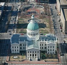
Gateway Arch National Park is an American national park located in St. Louis, Missouri, near the starting point of the Lewis and Clark Expedition.
Vincent C. Schoemehl, Jr. was the 42nd mayor of St. Louis, Missouri, serving three terms from 1981 to 1993. At the time of his first election, he was one of the city's youngest mayors. In 1992, Schoemehl was defeated in the Democratic primary by lieutenant governor Mel Carnahan in a bid to become Governor of Missouri. He is best known as being primarily responsible for the NFL St. Louis Cardinals relocating to Phoenix, Arizona, and the expansion of Lambert Airport and the start of the eminent domain destruction of the Carrolton neighborhood in the name of noise abatement.
Coran Capshaw is an American music industry executive, entrepreneur and founder of Red Light Management, a company that represents recording artists.

Grange Park is a prominent and well-used public park in downtown Toronto, Ontario in Canada. It is located south of the Art Gallery of Ontario, next to the Ontario College of Art and Design University (OCADU) and north of University Settlement House, at the north end of John Street. The Park lends its name to the Grange Park neighbourhood in the vicinity of the park. Historically, the park was the backyard of The Grange, a manor that was later expanded and became the Art Gallery of Ontario.

8th & Pine station is a light rail station on the Red and Blue lines of the St. Louis MetroLink system. This subway station is located beneath the intersection of 8th and Pine streets in St. Louis' Central Business District.

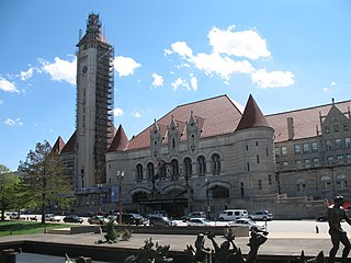
Transportation in Greater St. Louis, Missouri includes road, rail, ship, and air transportation modes connecting the bi-state St. Louis metropolitan area with surrounding communities throughout the Midwest, national transportation networks, and international locations. The Greater St. Louis region also supports a multi-modal transportation network that includes bus, paratransit, and light rail service in addition to shared-use paths, bike lanes and greenways.

Discovery Green is an 11.78-acre (47,700 m2) public urban park in Downtown Houston, Texas, bounded by La Branch Street to the west, McKinney Street to the north, Avenida de las Americas to the east, and Lamar Street to the south. The park is adjacent to the George R. Brown Convention Center and Avenida Houston entertainment district. Discovery Green features a lake, bandstands and venues for public performances, two dog runs, a playground, and multiple recreational lawns.

The Great Rivers Greenway District is a public agency created in 2000 to develop a regional network of greenways. Great Rivers Greenway engages citizens and community partners to plan, build and care for the greenways. In its first 20 years the agency built more than 128 miles of greenways connecting parks, rivers, schools, neighborhoods, business districts and transit.
Metropolitan Park is a 32-acre (130,000 m2) urban waterfront park and concert venue located on the north bank of the St. Johns River in Downtown Jacksonville, Florida. It is projected to be the eastern terminus of the northbank Jacksonville Riverwalk.
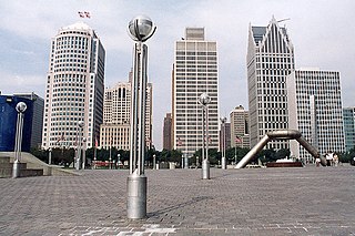
Philip A. Hart Plaza, in downtown Detroit, is a city plaza along the Detroit River. It is located more or less on the site at which Antoine Laumet de La Mothe, sieur de Cadillac landed in 1701 when he founded Fort Pontchartrain du Détroit, the settlement that became Detroit. In 2011, the Detroit-Wayne County Port Authority opened its new cruise ship passenger terminal and dock at Hart Plaza, adjacent to the Renaissance Center, which receives major cruise ships such as the MS Hamburg and the Yorktown.

The Gateway Mall in St. Louis, Missouri is an open green space running linearly, one block wide, from the Gateway Arch at Memorial Drive to Union Station at 20th Street. Located in the city's downtown, it runs between Market Street and Chestnut Street.
Aloe Plaza is a public park in the Downtown West neighborhood of St. Louis, Missouri. The park is part of the Gateway Mall and is bounded by Chestnut and Market streets on the north and south and 18th and 20th streets on the east and west.
The numbered streets of St. Louis, Missouri generally run north–south through the city, starting with 1st Street at the Mississippi River, and increasing in value the further west they are. 1st through 25th Streets are primarily centered around the Downtown and Downtown West neighborhoods, with many extending further north and south into other neighborhoods. There are a few other higher value streets that appear elsewhere in the St. Louis area, and although they are not adjacent to the 1st–25th grid in the eastern part of the city, their numberings in relation to their distances from the river are relatively consistent.
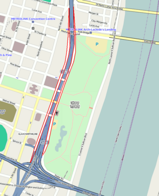
Memorial Drive runs north–south in Downtown St. Louis, Missouri. It is between the city's central business district and the grounds of the Gateway Arch and Gateway Arch National Park. It has an intimate relationship with Interstate 44 ; for most of its length, it runs above the sunken highway, but north of Washington Avenue it goes under it as the highway ramps up above the city.
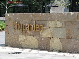
Citygarden is an urban park and sculpture garden in St. Louis, Missouri owned by the City of St. Louis but maintained by the Gateway Foundation. It is located between Eighth, Tenth, Market, and Chestnut streets, in the city's "Gateway Mall" area. Before being converted to a garden and park, the site comprised two empty blocks of grass. Citygarden was dedicated on June 30, 2009, and opened one day later, on July 1, 2009.
Parks in Greater St. Louis are administered by a variety of state, county, and municipal authorities. The region also is home to Gateway Arch National Park, site of the Gateway Arch, the only National Memorial in the state of Missouri. Among the largest municipal parks is Forest Park, which is 1,293 acres (5.2 km2) and is located in the city of St. Louis, although both Greensfelder County Park and Creve Coeur Park in St. Louis County are larger, at 1,646 and 2,114 acres respectively. St. Louis County is also the location of two large state parks, Babler State Park with 3.8 square miles (9.8 km2) and Castlewood State Park with 2.8 square miles (7.3 km2). The largest state park in the region is Meramec State Park, located near Sullivan, Missouri, with 10.8 square miles (28 km2) of parkland.
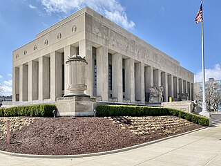
Memorial Plaza is a public park in the Downtown West neighborhood of St. Louis, Missouri. The park makes up the center section of the Gateway Mall and contains memorials honoring St. Louis veterans of World War I, World War II, and the Korean and Vietnam wars. The park extends from Tucker Boulevard to 18th Street between Market and Chestnut streets.

The Bi-State Development Agency was established as an interstate compact between Missouri and Illinois in 1949. This compact created an organization that has broad powers in seven county-level jurisdictions. Bi-State operates five enterprises including the Gateway Arch Riverfront, Metro Transit, the St. Louis Downtown Airport, the St. Louis Regional Freightway and the Bi-State Development Research Institute.

Horton Plaza Park is an outdoor venue located in the heart of downtown San Diego, which had its grand opening on May 4, 2016. Located on the corner of 4th Avenue and Broadway, the plaza preserves the history and integrity of the original Horton Plaza, while adding key features to enhance the area. In addition to restoring the Broadway Fountain, the park includes an amphitheater for live music acts, retail pavilions, and an interactive fountain. The plaza was designated a historical landmark by the City of San Diego on March 19, 1971. The city-owned park was designed by landscape architect Walker Macy and built by Civic San Diego.

World's Fair Park is a public park in downtown Knoxville, Tennessee. The park sits on the former fairgrounds of the 1982 World's Fair hosted in Knoxville. Today, the park is home to the Sunsphere and the Tennessee Amphitheater, the two remaining structures from the exposition.