Marquette, Iowa

Last updated

Marquette, Iowa
Marquette, Iowa (2016).jpg
Marquette in 2016
Clayton County Iowa Incorporated and Unincorporated areas Marquette Highlighted.svg
Location of Marquette, Iowa
Coordinates: 43°2′34″N91°11′3″W / 43.04278°N 91.18417°W / 43.04278; -91.18417
Country Flag of the United States.svg  United States
State Flag of Iowa.svg  Iowa
County Clayton
Area
[1]
  Total1.92 sq mi (4.98 km2)
  Land1.86 sq mi (4.81 km2)
  Water0.07 sq mi (0.17 km2)
Elevation
627 ft (191 m)
Population
 (2020)
  Total429
  Density231.14/sq mi (89.24/km2)
Time zone UTC-6 (Central (CST))
  Summer (DST) UTC-5 (CDT)
ZIP code
52158
Area code 563
FIPS code 19-49620
GNIS feature ID0458816

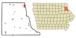
Marquette is a city in Clayton County, Iowa, United States. The population was 429 at the time of the 2020 census, up from 421 in 2000. [2] The city, which is located on the Mississippi River, is named after Jesuit missionary Jacques Marquette, who along with Louis Joliet discovered the Mississippi River just southeast of the city on June 17, 1673.

Contents

History

Pontoon bridge near Marquette, 1885 Old Pontoon Bridge North McGregor Iowa 1885.JPG
Pontoon bridge near Marquette, 1885

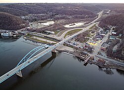
Marquette is located directly across from Prairie du Chien, Wisconsin, and the two cities are connected by U.S. Route 18, which crosses the river on the Marquette-Joliet Bridge. Effigy Mounds National Monument and the Yellow River State Forest are a few miles to the north. The city of McGregor is located just to the south. Marquette itself was originally incorporated as North McGregor in 1874, and it served as a railroad terminus for its southern neighbor.

Along with McGregor, the city became a major hub on the railroad, as grain from throughout Iowa and Minnesota was sent through the city en route to Lake Michigan. Initially trains had to be ferried across the river between Marquette and Prairie du Chien, Wisconsin, in order to continue their journey, but this system came to an end when Prairie du Chien businessman John Lawler had a permanent pontoon bridge built to connect the two cities' rail lines. Marquette subsequently became home to a major rail yard, which even as late as 1920 was the busiest in Iowa, employing 400 people. Not too long afterwards, the railroad's significance declined, the last passenger train stopped in Marquette in 1960, and the pontoon bridge was disassembled in 1961. Today the city is a tourist destination along the mighty Mississippi River.

Geography

According to the United States Census Bureau, the city has a total area of 1.81 square miles (4.69 km2), of which 1.74 square miles (4.51 km2) is land and 0.07 square miles (0.18 km2) is water. [3]

Demographics

Historical populations
YearPop.±%
1880 519    
1890 509−1.9%
1900 616+21.0%
1910 588−4.5%
1920 923+57.0%
1930 814−11.8%
1940 747−8.2%
1950 641−14.2%
1960 572−10.8%
1970 509−11.0%
1980 528+3.7%
1990 479−9.3%
2000 421−12.1%
2010 375−10.9%
2020 429+14.4%
Source: "U.S. Census website". United States Census Bureau . Retrieved March 29, 2020. and Iowa Data Center
Source:
U.S. Decennial Census [4] [2]

2010 census

As of the census [5] of 2010, there were 375 people, 182 households, and 104 families living in the city. The population density was 215.5 inhabitants per square mile (83.2/km2). There were 216 housing units at an average density of 124.1 per square mile (47.9/km2). The racial makeup of the city was 98.7% White, 0.8% Native American, 0.3% Asian, and 0.3% from two or more races. Hispanic or Latino of any race were 0.5% of the population.

There were 182 households, of which 24.2% had children under the age of 18 living with them, 45.1% were married couples living together, 6.6% had a female householder with no husband present, 5.5% had a male householder with no wife present, and 42.9% were non-families. 35.2% of all households were made up of individuals, and 13.7% had someone living alone who was 65 years of age or older. The average household size was 2.06 and the average family size was 2.60.

The median age in the city was 46.6 years. 19.2% of residents were under the age of 18; 6% were between the ages of 18 and 24; 23.7% were from 25 to 44; 30.2% were from 45 to 64; and 20.8% were 65 years of age or older. The gender makeup of the city was 49.9% male and 50.1% female.

2000 census

As of the census [6] of 2000, there were 421 people, 194 households, and 108 families living in the city. The population density was 345.2 inhabitants per square mile (133.3/km2). There were 222 housing units at an average density of 182.0 per square mile (70.3/km2). The racial makeup of the city was 98.57% White, 0.48% African American and 0.95% Native American. Hispanic or Latino of any race were 0.71% of the population.

There were 194 households, out of which 24.2% had children under the age of 18 living with them, 42.3% were married couples living together, 8.8% had a female householder with no husband present, and 44.3% were non-families. 37.6% of all households were made up of individuals, and 12.9% had someone living alone who was 65 years of age or older. The average household size was 2.17 and the average family size was 2.91.

Age spread: 22.3% under the age of 18, 9.0% from 18 to 24, 28.7% from 25 to 44, 26.8% from 45 to 64, and 13.1% who were 65 years of age or older. The median age was 39 years. For every 100 females, there were 91.4 males. For every 100 females age 18 and over, there were 97.0 males.

Education

It is within the MFL MarMac Community School District. [7] The district formed on July 1, 1994, with the merger of the Mar-Mac and M-F-L districts. [8]

Related Research Articles

<span class="mw-page-title-main">Crawford County, Wisconsin</span> County in Wisconsin, United States

Crawford County is a county in the southwest part of the U.S. state of Wisconsin. As of the 2020 census, the population was 16,113. Its county seat is Prairie du Chien.

<span class="mw-page-title-main">Clayton County, Iowa</span> County in Iowa, United States

Clayton County is a county located in the U.S. state of Iowa. As of the 2020 census, the population was 17,043. Its county seat is Elkader. The county was established in 1837 and was named in honor of John M. Clayton, United States Senator from Delaware and later Secretary of State under President Zachary Taylor.

<span class="mw-page-title-main">Farnhamville, Iowa</span> City in Iowa, United States

Farnhamville is a city in Calhoun and Webster counties in the U.S. state of Iowa. The population was 383 at the time of the 2020 census.

<span class="mw-page-title-main">Rinard, Iowa</span> City in Iowa, United States

Rinard is a city in Calhoun County, Iowa, United States. The population was 38 at the time of the 2020 census.

<span class="mw-page-title-main">Somers, Iowa</span> City in Iowa, United States

Somers is a city in Calhoun County, Iowa, United States. The population was 128 at the time of the 2020 census.

<span class="mw-page-title-main">Farmersburg, Iowa</span> City in Iowa, United States

Farmersburg is a city in Clayton County, Iowa, United States. The population was 271 at the time of the 2020 census, down from 300 in 2000. The current Mayor is Glenn Radloff, a cross-country truck driver.

<span class="mw-page-title-main">Guttenberg, Iowa</span> City in Iowa, United States

Guttenberg is a city in Clayton County, Iowa, United States, along the Mississippi River. The population was 1,817 at the time of the 2020 census, down from 1,987 at the 2000 census.

<span class="mw-page-title-main">Luana, Iowa</span> City in Iowa, United States

Luana is a city in Clayton County, Iowa, United States. The population was 301 at the time of the 2020 census, up from 249 in 2000.

<span class="mw-page-title-main">McGregor, Iowa</span> City in Iowa, United States

McGregor is a city in Clayton County, Iowa, United States. The population was 742 at the time of the 2020 census. McGregor is located on the Mississippi River across from Prairie du Chien, Wisconsin. Pike's Peak State Park is located just south of the city. Just to the north of McGregor is the city of Marquette. The community of McGregor Heights lies in the southern parts of the city limits.

<span class="mw-page-title-main">Monona, Iowa</span> City in Iowa, United States

Monona is a city in Clayton County, Iowa, United States. The population was 1,471 at the time of the 2020 census.

<span class="mw-page-title-main">Dakota City, Iowa</span> City in Iowa, United States

Dakota City is a city in and the county seat of Humboldt County, Iowa, United States. The population was 759 at the time of the 2020 census. Dakota City shares its western border with the much larger city of Humboldt. It is the least populous county seat in Iowa.

<span class="mw-page-title-main">Houghton, Iowa</span> City in Iowa, United States

Houghton is a city in Lee County, Iowa, United States. The population was 141 at the 2020 census. It is part of the Fort Madison–Keokuk, IA-MO Micropolitan Statistical Area.

<span class="mw-page-title-main">St. Paul, Iowa</span> City in Iowa, United States

St. Paul is a city in Lee County, Iowa, United States. The population was 109 at the time of the 2020 census. It is part of the Fort Madison–Keokuk, IA-MO Micropolitan Statistical Area.

<span class="mw-page-title-main">West Point, Iowa</span> City in Iowa, United States

West Point is a city in Lee County, Iowa, United States. The population was 921 at the time of the 2020 census. It is part of the Fort Madison–Keokuk, IA-MO Micropolitan Statistical Area.

<span class="mw-page-title-main">Wapello, Iowa</span> City in Iowa, United States

Wapello is a city in and the county seat of Louisa County, Iowa, United States. The population was 2,084 at the time of the 2020 census.

<span class="mw-page-title-main">Moorland, Iowa</span> City in Iowa, United States

Moorland is a small town in Webster County, Iowa, United States. The population was 168 at the time of the 2020 census.

<span class="mw-page-title-main">Marquette, Kansas</span> City in McPherson County, Kansas

Marquette is a city in McPherson County, Kansas, United States. As of the 2020 census, the population of the city was 599. It is located between K-4 and the Smoky Hill River.

<span class="mw-page-title-main">Wabasha, Minnesota</span> City in Minnesota, United States

Wabasha is a city and the county seat of Wabasha County, Minnesota. The population was 2,559 at the time of the 2020 census. It is on the Mississippi River, near its confluence with the Zumbro River.

<span class="mw-page-title-main">Bevington, Iowa</span> City in Iowa, United States

Bevington is a city in Madison and Warren Counties in the U.S. state of Iowa. The population was 57 at the 2020 census. It is part of the Des Moines–West Des Moines Metropolitan Statistical Area.

<span class="mw-page-title-main">Prairie du Chien, Wisconsin</span> US city and county seat

Prairie du Chien is a city in and the county seat of Crawford County, Wisconsin, United States. The population was 5,506 at the 2020 census. Its ZIP code is 53821.

References

  1. "2020 U.S. Gazetteer Files". United States Census Bureau. Retrieved March 16, 2022.
  2. 1 2 "2020 Census State Redistricting Data". census.gov. United states Census Bureau. Retrieved August 12, 2021.
  3. "US Gazetteer files 2010". United States Census Bureau. Archived from the original on January 25, 2012. Retrieved May 11, 2012.
  4. "Census of Population and Housing". Census.gov. Retrieved June 4, 2015.
  5. "U.S. Census website". United States Census Bureau . Retrieved May 11, 2012.
  6. "U.S. Census website". United States Census Bureau . Retrieved January 31, 2008.
  7. "MFL Mar Mac" (PDF). Iowa Department of Education . Retrieved March 27, 2020.
  8. "REORGANIZATION & DISSOLUTION ACTIONS SINCE 1965-66" (PDF). Iowa Department of Education. Archived from the original (PDF) on February 9, 2019. Retrieved March 22, 2020.