Monona, Iowa

Last updated
Monona, Iowa
WaterTowerMononaIowa.jpg
Monona water tower
Motto: 
The Garden City.
Clayton County Iowa Incorporated and Unincorporated areas Monona Highlighted.svg
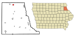
Location of Monona, Iowa
Coordinates: 43°3′5″N91°23′26″W / 43.05139°N 91.39056°W / 43.05139; -91.39056 Coordinates: 43°3′5″N91°23′26″W / 43.05139°N 91.39056°W / 43.05139; -91.39056
Country Flag of the United States.svg  United States
State Flag of Iowa.svg  Iowa
County Clayton
Area
[1]
  Total1.36 sq mi (3.53 km2)
  Land1.36 sq mi (3.53 km2)
  Water0.00 sq mi (0.00 km2)
Elevation
1,214 ft (370 m)
Population
 (2020)
  Total1,471
  Density1,080.03/sq mi (416.90/km2)
Time zone UTC-6 (Central (CST))
  Summer (DST) UTC-5 (CDT)
ZIP code
52159
Area code 563
FIPS code 19-53310
GNIS feature ID0459174
Website City of Monona Website

Monona is a city in Clayton County, Iowa, United States. The population was 1,471 at the time of the 2020 census. [2]

Contents

History

The name Monona is of American native origin. [3]

In 1916, Monona contained a public house, two stores, and several mechanic shops. [4]

Geography

Monona is located at 43°3′5″N91°23′26″W / 43.05139°N 91.39056°W / 43.05139; -91.39056 (43.051258, -91.390529). [5]

According to the United States Census Bureau, the city has a total area of 1.17 square miles (3.03 km2), all land. [6]

Demographics

Historical populations
YearPop.±%
1880 420    
1890 460+9.5%
1900 674+46.5%
1910 792+17.5%
1920 1,049+32.4%
1930 1,163+10.9%
1940 1,191+2.4%
1950 1,346+13.0%
1960 1,346+0.0%
1970 1,395+3.6%
1980 1,530+9.7%
1990 1,520−0.7%
2000 1,550+2.0%
2010 1,549−0.1%
2020 1,471−5.0%
Source: "U.S. Census website". United States Census Bureau . Retrieved 2020-03-29. and Iowa Data Center
Source:
U.S. Decennial Census [7] [2]

2010 census

At the 2010 census there were 1,549 people, 675 households, and 440 families living in the city. The population density was 1,323.9 inhabitants per square mile (511.2/km2). There were 725 housing units at an average density of 619.7 per square mile (239.3/km2). The racial makeup of the city was 98.3% White, 0.5% African American, 0.1% Native American, 0.3% Asian, 0.3% from other races, and 0.6% from two or more races. Hispanic or Latino of any race were 1.0%. [8]

Of the 675 households, 29.5% had children under the age of 18 living with them, 52.1% were married couples living together, 8.7% had a female householder with no husband present, 4.3% had a male householder with no wife present, and 34.8% were non-families. 30.8% of households were one person and 16.6% were one person aged 65 or older. The average household size was 2.29 and the average family size was 2.83.

The median age was 42.4 years. 23.6% of residents were under the age of 18; 6.9% were between the ages of 18 and 24; 22.7% were from 25 to 44; 26.5% were from 45 to 64; and 20.2% were 65 or older. The gender makeup of the city was 48.5% male and 51.5% female.

2000 census

At the 2000 census there were 1,550 people, 659 households, and 432 families living in the city. The population density was 1,344.6 inhabitants per square mile (519.2/km2). There were 706 housing units at an average density of 612.4 per square mile (236.4/km2). The racial makeup of the city was 98.65% White, 0.06% African American, 0.58% Native American, 0.39% Asian, and 0.32% from two or more races. Hispanic or Latino of any race were 0.06%. [9]

Of the 659 households, 28.7% had children under the age of 18 living with them, 55.4% were married couples living together, 5.8% had a female householder with no husband present, and 34.4% were non-families. 30.3% of households were one person and 19.0% were one person aged 65 or older. The average household size was 2.35 and the average family size was 2.93.

Age spread: 24.1% under the age of 18, 6.5% from 18 to 24, 26.9% from 25 to 44, 19.2% from 45 to 64, and 23.4% 65 or older. The median age was 40 years. For every 100 females, there were 90.9 males. For every 100 females age 18 and over, there were 89.7 males.

The median household income was $35,000 and the median family income was $42,679. Males had a median income of $28,942 versus $19,954 for females. The per capita income for the city was $18,746. About 5.2% of families and 7.3% of the population were below the poverty line, including 6.2% of those under age 18 and 9.0% of those age 65 or over.

Education

It is within the MFL MarMac Community School District. [10] The district formed on July 1, 1994, with the merger of the Mar-Mac and M-F-L districts. [11]

Notable people


Related Research Articles

<span class="mw-page-title-main">Monona County, Iowa</span> County in Iowa, United States

Monona County is a county located in the U.S. state of Iowa. As of the 2020 census, the population was 8,751. The county seat is Onawa.

<span class="mw-page-title-main">Clayton County, Iowa</span> County in Iowa, United States

Clayton County is a county located in the U.S. state of Iowa. As of the 2020 census, the population was 17,043. Its county seat is Elkader. The county was established in 1837 and was named in honor of John M. Clayton, United States Senator from Delaware and later Secretary of State under President Zachary Taylor.

<span class="mw-page-title-main">Yetter, Iowa</span> City in Iowa, United States

Yetter is a city in Calhoun County, Iowa, United States. The population was 19 at the time of the 2020 census.

<span class="mw-page-title-main">Farmersburg, Iowa</span> City in Iowa, United States

Farmersburg is a city in Clayton County, Iowa, United States. The population was 271 at the time of the 2020 census, down from 300 in 2000. The current Mayor is Glenn Radloff, a cross-country truck driver.

<span class="mw-page-title-main">Luana, Iowa</span> City in Iowa, United States

Luana is a city in Clayton County, Iowa, United States. The population was 301 at the time of the 2020 census, up from 249 in 2000.

<span class="mw-page-title-main">Marquette, Iowa</span> City in Iowa, United States

Marquette is a city in Clayton County, Iowa, United States. The population was 429 at the time of the 2020 census, up from 421 in 2000. The city, which is located on the Mississippi River, is named after Jesuit missionary Jacques Marquette, who along with Louis Joliet discovered the Mississippi River just southeast of the city on June 17, 1673.

<span class="mw-page-title-main">St. Donatus, Iowa</span> City in Iowa, United States

St. Donatus is a city in Jackson County, Iowa, United States. The population was 120 at the time of the 2020 census. St. Donatus is known for its status as a Luxembourger village, with historic architecture and views along U.S. Route 52. It is the home of a historic Catholic church, which is dedicated to Saint Donatus of Muenstereifel, the town's namesake. It was formerly named Tetes des Morts, which is the name of a creek that flows through the village.

<span class="mw-page-title-main">Hills, Iowa</span> City in Iowa, United States

Hills is a city in Johnson County, Iowa, United States. It is part of the Iowa City, Iowa Metropolitan Statistical Area. The population was 863 at the time of the 2020 census. It is part of the Iowa City Community School District.

<span class="mw-page-title-main">Blencoe, Iowa</span> City in Iowa, United States

Blencoe is a city in Monona County, Iowa, United States. The population was 233 at the 2020 census.

<span class="mw-page-title-main">Moorhead, Iowa</span> City in Iowa, United States

Moorhead is a city in Monona County, Iowa, United States. Moorhead stands along the Soldier River. The population was 199 at the time of the 2020 census.

<span class="mw-page-title-main">Onawa, Iowa</span> City in Iowa, USA

Onawa is a city in, and the county seat of, Monona County, Iowa, United States. The population was 2,906 at the time of the 2020 Census. It is the largest town on the Iowa side of the Missouri River between Council Bluffs and Sioux City.

<span class="mw-page-title-main">Soldier, Iowa</span> City in Iowa, United States

Soldier is a city in Monona County, Iowa, United States, along the Soldier River. The population was 184 at the time of the 2020 census.

<span class="mw-page-title-main">Turin, Iowa</span> City in Iowa, United States

Turin is a city in Monona County, Iowa, United States. The population was 72 at the time of the 2020 census.

<span class="mw-page-title-main">Ute, Iowa</span> City in Iowa, United States

Ute is a city in Monona County, Iowa, United States, along the Soldier River. The population was 338 at the time of the 2020 census.

<span class="mw-page-title-main">Whiting, Iowa</span> City in Iowa, United States

Whiting is a city in Monona County, Iowa, United States. The population was 745 at the time of the 2020 census.

<span class="mw-page-title-main">Hancock, Iowa</span> City in Iowa, United States

Hancock is a city in Pottawattamie County, Iowa, United States, along the West Nishnabotna River. The population was 200 at the time of the 2020 census.

<span class="mw-page-title-main">McClelland, Iowa</span> City in Iowa, United States

McClelland is a city in Pottawattamie County, Iowa, United States. The city was founded in 1903 after the Great Western Railroad was extended to include Council Bluffs, IA. The population was 146 at the time of the 2020 census.

<span class="mw-page-title-main">Ellenboro, West Virginia</span> Town in West Virginia, United States

Ellenboro is a town in Ritchie County, West Virginia, United States. The population was 222 at the 2020 census. The town is located at the junction of U.S. Route 50 and West Virginia Route 16; the North Bend Rail Trail also passes through the town. The town was named for Ellen Mariah Williamson, the eldest daughter of the family that granted a right of way for the Baltimore and Ohio Railroad to build their line through the town; an earlier name for the community was Shumley. Ellenboro was incorporated in 1903.

<span class="mw-page-title-main">Monona, Wisconsin</span> City in Wisconsin, United States

Monona is a city in Dane County, Wisconsin, United States. A suburb of the state capital, Madison, the city lies on the southeastern shore of Lake Monona, from which the city gets its name. The population was 8,624 at the 2020 census.

<span class="mw-page-title-main">Excelsior Estates, Missouri</span> 4th Class City in Missouri in the United States

Excelsior Estates is a village in Clay and Ray counties in the U.S. state of Missouri and part of the Kansas City metropolitan area. The population was 209 at the 2020 census.

References

  1. "2020 U.S. Gazetteer Files". United States Census Bureau. Retrieved March 16, 2022.
  2. 1 2 "2020 Census State Redistricting Data". census.gov. United states Census Bureau. Retrieved 12 August 2021.
  3. "Profile for Monona, Iowa". ePodunk. Retrieved 22 February 2014.
  4. Price, Realto E. (1916). History of Clayton County, Iowa: From the Earliest Historical Times Down to the Present. Robert O. Law Company. pp.  86.
  5. "US Gazetteer files: 2010, 2000, and 1990". United States Census Bureau. 2011-02-12. Retrieved 2011-04-23.
  6. "US Gazetteer files 2010". United States Census Bureau. Archived from the original on 2012-01-25. Retrieved 2012-05-11.
  7. "Census of Population and Housing". Census.gov. Retrieved June 4, 2015.
  8. "U.S. Census website". United States Census Bureau . Retrieved 2012-05-11.
  9. "U.S. Census website". United States Census Bureau . Retrieved 2008-01-31.
  10. "MFL Mar Mac" (PDF). Iowa Department of Education . Retrieved 2020-03-27.
  11. "REORGANIZATION & DISSOLUTION ACTIONS SINCE 1965-66" (PDF). Iowa Department of Education. Archived from the original (PDF) on 2019-02-09. Retrieved 2020-03-22.