Clayton Center, Iowa

Last updated
Clayton Center, Iowa
Zion Lutheran Church, Clayton Center, IA.jpg
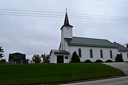
Zion Lutheran Church in Clayton Center
USA Iowa location map.svg
Red pog.svg
Clayton Center, Iowa
Usa edcp location map.svg
Red pog.svg
Clayton Center, Iowa
Coordinates: Coordinates: 42°53′00″N91°19′36″W / 42.88333°N 91.32667°W / 42.88333; -91.32667
Country United States
State Iowa
County Clayton
Elevation
988 ft (301 m)
Time zone UTC-6 (Central (CST))
  Summer (DST) UTC-5 (CDT)
Area code 563
GNIS feature ID455451

Clayton Center is an unincorporated community located in Clayton County, Iowa, United States.

Contents

History

The area was settled as a German colony, approximately five miles east of Elkader. In April 1856, the land was surveyed by Lewis Brockman, who established the location as the "southeast quarter of section 8, township 93 north, range 3 west." [1] Clayton Center was then platted on June 27, 1857, by Fred Hartmann. [2] Clayton Center's population was 94 in 1902. [3]

Education

Public schools are operated by the Clayton Ridge Community School District, which formed in 2005 with the merger of the Guttenberg and Garnavillo Community School Districts. [4] Students were previously zoned to Garnavillo schools. [5]

Related Research Articles

<span class="mw-page-title-main">Monmouth County, New Jersey</span> County in New Jersey, United States

Monmouth County is a county located on the northern part of the Jersey Shore in the U.S. state of New Jersey. The county is part of the New York metropolitan area. As of the 2020 United States census, the county was the state's fifth-most-populous county with a population of 643,615, its highest decennial count ever and an increase of 13,235 (+2.1%) from the 2010 census count of 630,380, which in turn reflected an increase of 15,079 from 615,301 at the 2000 census. As of 2010, the county fell to the fifth-most populous county in the state, having been surpassed by Hudson County. Monmouth County's geographic area comprises 30% water.

<span class="mw-page-title-main">Middlesex County, New Jersey</span> County in New Jersey, United States

Middlesex County is located in central New Jersey, United States, extending inland from the Raritan Valley region to the northern portion of the Jersey Shore. As of the 2020 United States Census, the county's population was enumerated at 863,162, its highest decennial count ever and an increase of 53,304 (6.6%) from the 809,858 residents counted at the 2010 census. Middlesex is New Jersey's third-most populous county and is part of the New York metropolitan area. Many communities within the county serve as commuter towns to and from New York City and other points north.

<span class="mw-page-title-main">Clayton County, Iowa</span> County in Iowa, United States

Clayton County is a county located in the U.S. state of Iowa. As of the 2020 census, the population was 17,043. Its county seat is Elkader. The county was established in 1837 and was named in honor of John M. Clayton, United States Senator from Delaware and later Secretary of State under President Zachary Taylor.

<span class="mw-page-title-main">Clayton, Iowa</span> City in Iowa, United States

Clayton is a city in Clayton County, Iowa, United States. The population was 45 at the 2020 census, down from 55 in 2000. Clayton is located directly on the Mississippi River and is only accessible via a very steep road.

<span class="mw-page-title-main">Garnavillo, Iowa</span> City in Iowa, United States

Garnavillo is a city in Clayton County, Iowa, United States. The population was 763 at the time of the 2020 census, up from 754 in 2000.

<span class="mw-page-title-main">Guttenberg, Iowa</span> City in Iowa, United States

Guttenberg is a city in Clayton County, Iowa, United States, along the Mississippi River. The population was 1,817 at the time of the 2020 census, down from 1,987 at the 2000 census.

<span class="mw-page-title-main">Osterdock, Iowa</span> City in Iowa, United States

Osterdock is a city located in Clayton County, Iowa, United States. As of the 2020 census, the city had a total population of 43, down from 50 in 2000.

<span class="mw-page-title-main">Clayton, New Jersey</span> Place in Gloucester County, New Jersey, United States

Clayton is a borough in Gloucester County in the U.S. state of New Jersey. As of the 2020 United States census, the borough's population was 8,807, an increase of 628 (+7.7%) from the 2010 census count of 8,179, which in turn reflected an increase of 1,040 (+14.6%) from the 7,139 counted in the 2000 census.

<span class="mw-page-title-main">Monti, Iowa</span> Unincorporated community in Iowa, United States

Monti is an unincorporated community located in the southeast corner of Buchanan County, Iowa, United States. Founded in the 1880s and platted in 1905, the community lies on the west bank of Buffalo Creek, 6 miles (10 km) east of Quasqueton and 8 miles (13 km) west of Ryan.

<span class="mw-page-title-main">Second Ward, Houston</span>

Second Ward is a historical political district ward in the East End community in Houston, Texas. It was one of the four original wards of the city in the nineteenth century. The community known as the Second Ward today is roughly bounded by Buffalo Bayou to the north, Lockwood Avenue to the east, and railroad tracks to the south and west, although the City of Houston's "Super Neighborhood" program includes a section east of Lockwood.

Burnside is an unincorporated community in Webster County, Iowa, United States. Its elevation is 1,138 feet (347 m). Burnside has a post office with the ZIP code 50521.

Communia is an unincorporated community located in Clayton County, Iowa, United States, in the south half of section 8, Volga Township. The area was established as a German colony in 1847.

Elias Hewitt Williams was a justice of the Iowa Supreme Court from January 18, 1870 to September 14, 1870, appointed from Clayton County, Iowa.

The Garnavillo Township Bridge is a historic structure located west of Garnavillo, Iowa, United States. It spans an unnamed stream for 20 feet (6.1 m). Around the turn of the 20th-century Clayton County embarked on a project to replace its old bridges. On short crossing like this one they generally chose simple timber stringer structures. But for this one, and several others, they chose to take advantage of the large limestone deposits in the county. They contracted with stonemason A.C. Boyle of McGregor, Iowa to build this single deck arch bridge for $1,462.72. It replaced an old combination truss span. This bridge also been replaced, but it remains in place underneath the newer bridge. It was listed on the National Register of Historic Places in 1998.

The Garnavillo Township Culvert is a historic structure located west of Garnavillo, Iowa, United States. It spans an unnamed stream for 14 feet (4.3 m). On April 4, 1899, C.G. Stickfort and others petitioned the county for a bridge at this location. The Clayton County Board of Supervisors contracted with Josef Vogt of Guttenberg, Iowa to build this single stone arch culvert of native limestone. It is no longer in use, but remains in place west of Iris Avenue. The culvert was listed on the National Register of Historic Places in 1998.

Cornelia is an unincorporated community in Grant Township, Wright County, Iowa, United States. Cornelia is located along County Highway C25, 4.8 miles (7.7 km) north-northeast of Clarion. Lake Cornelia State Park is in the community.

Titonka Consolidated School District was a school district headquartered in Titonka, Iowa, United States.

<span class="mw-page-title-main">Clayton Ridge Community School District</span> Public school district in Guttenberg, Iowa, United States

Clayton Ridge Community School District is a rural public school district in Clayton County, Iowa, serving Guttenberg, Garnavillo, Clayton, North Buena Vista, and Osterdock. In addition, Clayton Center is zoned to Clayton Ridge schools, as well as areas around Garber. The school mascot is the Eagles, and the colors are green, black and silver.

Guttenberg Community School District (GCSD) was a school district headquartered in Guttenberg, Iowa.

Garnavillo Community School District was a school district headquartered in Garnavillo, Iowa. In addition to Garnavillo it served Clayton, Buck Creek, Clayton Center, and National, as well as areas around Garber.

References

  1. History of Clayton County 1882 Archived 2015-01-04 at the Wayback Machine , Chapter XXXVIII: Read Township, page 1072-1073.
  2. History of Clayton County, Iowa Volume 1, pages 107, 322, 492.
  3. Cram's Modern Atlas: The New Unrivaled New Census Edition. J. R. Gray & Company. 1902. pp. 203–207.
  4. "REORGANIZATION & DISSOLUTION ACTIONS SINCE 1965-66 Archived 2018-06-19 at the Wayback Machine ." Iowa Department of Education. Retrieved on February 23, 2019.
  5. "History." Garnavillo Community School District. May 29, 2000. Retrieved on February 24, 2019.