St. John the Baptist Parish is a parish located in the U.S. state of Louisiana. At the 2020 census, the population was 42,477. The parish seat is Edgard, an unincorporated area, and the largest city is LaPlace, which is also unincorporated.

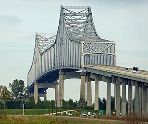
The Crescent City Connection (CCC), formerly the Greater New Orleans (GNO) Bridge, is a pair of cantilever bridges that carry U.S. Highway 90 Business over the Mississippi River in New Orleans, Louisiana, United States. They are tied as the fifth-longest cantilever bridges in the world. Each span carries four general-use automobile lanes; additionally the westbound span has two reversible HOV lanes across the river.
The Sunshine Bridge is a cantilever bridge over the Mississippi River in St. James Parish, Louisiana. Completed in 1963, it carries Louisiana Highway 70 (LA70), which connects Donaldsonville on the west bank of Ascension Parish with Sorrento on the east bank of Ascension Parish as well as with Gonzales on the east bank of Ascension Parish. The approach roads on the east and west banks begin in Ascension Parish before crossing into St. James Parish.

The Huey P. Long - O.K. Allen Bridge is a truss cantilever bridge over the Mississippi River carrying US 190 and one rail line between East Baton Rouge Parish, Louisiana and West Baton Rouge Parish, Louisiana.

Louisiana Highway 1 (LA 1) is a state highway in Louisiana. At 431.88 miles (695.04 km), it is the longest numbered highway of any class in Louisiana. It runs diagonally across the state, connecting the oil and gas fields near the island of Grand Isle with the northwest corner of the state, north of Shreveport.

U.S. Highway 90 (US 90), one of the major east–west U.S. Highways in the Southern United States, runs through southern Louisiana for 297.6 miles (478.9 km), serving Lake Charles, Lafayette, New Iberia, Morgan City, and New Orleans. Much of it west of Lafayette and east of New Orleans has been supplanted by Interstate 10 (I-10) for all but local traffic, but the section between Lafayette and New Orleans runs a good deal south of I-10.

The John James Audubon Bridge, completed and opened in May 2011, is a Lower Mississippi River crossing between Pointe Coupee and West Feliciana parishes in south central Louisiana. The bridge has the second longest cable-stayed span in the Western Hemisphere at 1,583 ft (482 m), after Mexico's Baluarte Bridge with a 1,706 ft (520 m) span, and has a total length of 12,883 ft (3,927 m)—nearly three-and-a-half times longer than the Baluarte Bridge's 3,688 ft (1,124 m) total length. The Audubon Bridge replaces the ferry between the communities of New Roads and St. Francisville. The bridge also serves as the only bridge structure on the Mississippi River between Natchez, Mississippi and Baton Rouge, Louisiana. The bridge conveys Louisiana Highway 10, which is in a concurrence there with the Zachary Taylor Parkway.

Louisiana Highway 18 is a state highway that serves Ascension, St. James, St. John the Baptist, St. Charles, and Jefferson Parishes. Called the Great River Road, it runs from west to east, parallel to the west bank of the Mississippi River, running from Donaldsonville to Gretna. It spans a total of 79.7 miles (128.3 km). In the more rural parts of LA 18's span, it is commonly referred to as River Road, but it becomes 4th Street once it enters Westwego.
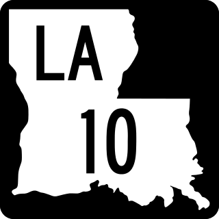
Louisiana Highway 10 (LA 10) is a state highway located in southern Louisiana. It runs 255.51 miles (411.20 km) in an east–west direction from U.S. Highway 171 (US 171) south of Leesville to the Mississippi state line east of Bogalusa.

Louisiana Highway 20 is a state highway that serves Terrebonne Parish, Lafourche Parish, and St. James Parish. It spans a total of 36.6 miles (58.9 km) as a two lane, undivided road.
Louisiana Highway 3127 is a state highway in Louisiana that serves Ascension, St. James, St. John the Baptist, and St. Charles Parishes. It spans 42.1 miles (67.8 km) in a northwest to southeast direction. It parallels LA 18 along the west bank of the Mississippi River, providing a much shorter inland bypass of the River Road. It is bannered in all four cardinal directions depending upon the part of the route.

U.S. Highway 65 (US 65) is a part of the United States Numbered Highway System that spans 966 miles (1,555 km) from Clayton, Louisiana to Albert Lea, Minnesota. Within the state of Louisiana, the highway travels 100.77 miles (162.17 km) from the national southern terminus at US 425/LA 15 in Clayton to the Arkansas state line north of Lake Providence.
Louisiana Highway 641 (LA 641) is a state highway in Louisiana that serves St. James Parish. It travels 6.9 miles (11.1 km) in the shape of a capital J, starting northwest, veering northeast, and then turning north, serving the communities of Lutcher and Gramercy and providing a connection to Interstate 10 (I-10) for those towns.

Louisiana Highway 44 is a state highway in Louisiana that serves Ascension, St. James, and St. John the Baptist Parishes. It runs from west to east, parallel to the east bank of the Mississippi River, from Prairieville to LaPlace. It spans a total of 50.1 miles (80.6 km). Throughout its run, LA 44 is known as North/South Burnside Avenue, River Road, West/East Jefferson Highway, West 5th Street, and Main Street.
Louisiana Highway 75 (LA 75) is a state highway located in southeastern Louisiana. It runs 46.86 miles (75.41 km) in a general east–west direction from a dead end in Bayou Pigeon to the junction of LA 22 and LA 942 in Darrow.