A state highway, state road, or state route is usually a road that is either numbered or maintained by a sub-national state or province. A road numbered by a state or province falls below numbered national highways in the hierarchy. Roads maintained by a state or province include both nationally numbered highways and un-numbered state highways. Depending on the state, "state highway" may be used for one meaning and "state road" or "state route" for the other.
Louisiana is a state in the Deep South region of the South Central United States. It is the 31st most extensive and the 25th most populous of the 50 United States. Louisiana is bordered by the state of Texas to the west, Arkansas to the north, Mississippi to the east, and the Gulf of Mexico to the south. A large part of its eastern boundary is demarcated by the Mississippi River. Louisiana is the only U.S. state with political subdivisions termed parishes, which are equivalent to counties. The state's capital is Baton Rouge, and its largest city is New Orleans.
Ascension Parish is a parish located in the U.S. state of Louisiana. As of the 2010 census, the population was 107,215. Its parish seat is Donaldsonville. The parish was created in 1807.
From the west, LA 44 begins at an intersection with LA 42 (Oak Grove-Port Vincent Highway) in Prairieville. The highway travels south along North Burnside Avenue into Gonzales where it intersects with US 61 (North Airline Highway). Passing through downtown Gonzales, LA 44 has a brief concurrency with LA 429. After several blocks, the local name changes to South Burnside Avenue at an intersection with LA 3038 (East Cornerview Street), and LA 429 splits off to the west along West Cornerview Street. Leaving Gonzales, LA 44 continues south and intersects with I-10.
Louisiana Highway 42 is a state highway in Louisiana that serves East Baton Rouge, Ascension, Livingston, and Tangipahoa parishes. It spans 47.8 miles (76.9 km) in a general east–west direction.
Port Vincent is a village in Livingston Parish, Louisiana, United States. The population was 741 at the 2010 census. It is part of the Baton Rouge Metropolitan Statistical Area.
Gonzales is a small city in Ascension Parish, Louisiana, United States. As of the 2010 census, it had a population of 9,781. Known as the "Jambalaya Capital of the World", it is famous for its annual Jambalaya Festival, which was first held in 1968. Stephen "Steve" F. Juneau came up with the idea for the Jambalaya Festival and served as the first president of the Jambalaya Festival Association.
After three miles, LA 44 intersects with LA 22 as that highway runs between Sorrento and Darrow. A mile later, LA 44 reaches the east bank of the Mississippi River at an intersection with LA 942 at Burnside. Here, the route turns onto the River Road and soon crosses from Ascension Parish into St. James Parish. It then passes under and connects with the Sunshine Bridge, part of LA 70 to Donaldsonville.
Louisiana Highway 22 (LA 22) is a state highway located in southeastern Louisiana. It runs 71.15 miles (114.50 km) in a general east–west direction from the junction of LA 75 and LA 942 in Darrow to U.S. Highway 190 (US 190) in Mandeville.
Sorrento is a town in Ascension Parish, Louisiana, United States. The population was 1,227 at the 2000 census. By the 2010 census it had grown 14.2%, to 1,401 inhabitants. It is part of the Baton Rouge Metropolitan Statistical Area.
Darrow is an unincorporated community in Ascension Parish, Louisiana, United States. It is the location of three properties listed on the U.S. National Register of Historic Places: Bocage, Helvetia Dependency, and Hermitage plantations.
Continuing downriver, LA 44 begins to follow a generally eastward direction passing through the communities of Convent, Paulina, Lutcher, and Gramercy. Jefferson Highway, the local name in use beginning in Lutcher, is a vestige of the road being part of that historic auto trail in the 1910s and 1920s. On the east side of Gramercy, LA 44 passes under and connects with a second Mississippi River crossing known as the Gramercy Bridge, part of LA 3213, just before entering St. John the Baptist Parish.
Convent is a census-designated place in and the parish seat of St. James Parish, Louisiana, United States. As of the 2010 census, its population was 711. It has been the parish seat since 1869.
Paulina is an unincorporated community and census-designated place in St. James Parish, Louisiana, United States. Its population was 1,178 as of the 2010 census. The community is located on the east bank of the Mississippi River in the eastern part of the parish, west of Lutcher and across the river from Vacherie. Paulina has a post office with ZIP code 70763.
Lutcher is a town in St. James Parish, Louisiana, United States, on the East Bank of the Mississippi River. The population was 3,559 at the 2000 census.
Continuing along the Mississippi River, LA 44 runs parallel to US 61 (Airline Highway) and passes through the communities of Mt. Airy, Garyville, Lions, and Reserve. LA 44 then enters LaPlace, turning away from the river at an intersection with LA 636 onto West 5th Street. Almost two miles later, LA 44 turns northeast onto Main Street at LA 628. The route ends at US 61 (West/East Airline Highway) near the southern terminus of US 51.
Garyville is a census-designated place (CDP) in St. John the Baptist Parish, Louisiana, United States. The population was 2,775 at the 2000 census. It is part of the New Orleans–Metairie–Kenner Metropolitan Statistical Area. Garyville has the distinction of being the location of the most recently built oil refinery in the United States; it was established in 1976 by Marathon Petroleum Company.
Reserve is a census-designated place (CDP) in St. John the Baptist Parish, Louisiana, United States, on the east bank of the Mississippi River. The population was 9,111 at the 2000 census.
U.S. Route 51 is a major south-north United States highway that extends 1,277 miles (2,055 km) from the western suburbs of New Orleans, Louisiana, to within 150 feet (46 m) of the Wisconsin–Michigan state line. Much of the highway in northern Illinois and southern Wisconsin runs parallel to or is cosigned with Interstate 39 (I-39) and much of the route in several states also parallels the Illinois Central Railroad. The highway's northern terminus is between Hurley, Wisconsin, and Ironwood, Michigan, where it ends with a T interchange at US 2. Its southern terminus is Laplace, Louisiana, ending at US 61.
LA 44 is an undivided, two-lane highway from LA 42 to LA 621 in Gonzales, where it widens into an undivided, four-lane highway. At LA 30, LA 44 becomes a divided four-lane highway to just south of I-10, where it reverts to an undivided, two-lane highway for the remainder of its route to LaPlace.
Louisiana Highway 30 (LA 30) is a state highway located in southeastern Louisiana. It runs 28.10 miles (45.22 km) in a northwest to southeast direction from LA 73 in Baton Rouge to the junction of U.S. Highway 61 (US 61) and LA 431 east of Gonzales.
History
The portion of LA 44 running along the Mississippi River was once part of the Jefferson Highway auto trail designated in 1916 and the main traffic route between New Orleans and Baton Rouge prior to the construction of the Airline Highway in the 1930s. In 1921, it became part of State Route 1 in the pre-1955 Louisiana highway system and the original alignment of US 61 in 1926. US 61 also followed the Gonzales-Burnside section of LA 44 (pre-1955 State Route 88) briefly before being completely removed from the route following the opening of the Airline Highway in 1933.
Airline Highway is a divided highway in the U.S. state of Louisiana, built in stages between 1925 and 1953 to bypass the older Jefferson Highway. It runs 115.6 miles (186.0 km), carrying U.S. Highway 61 from New Orleans northwest to Baton Rouge and U.S. Highway 190 from Baton Rouge west over the Mississippi River on the Huey P. Long Bridge. US 190 continues west towards Opelousas on an extension built at roughly the same time.
Louisiana Highway 18 is a state highway that serves Ascension, St. James, St. John the Baptist, St. Charles, and Jefferson Parishes. Called the Great River Road, it runs from west to east, parallel to the west bank of the Mississippi River, running from Donaldsonville to Gretna. It spans a total of 79.7 miles (128.3 km). In the more rural parts of LA 18's span, it is commonly referred to as River Road, but it becomes 4th Street once it enters Westwego.
Louisiana Highway 20 is a state highway that serves Terrebonne Parish, Lafourche Parish, and St. James Parish. It spans a total of 36.6 miles (58.9 km) as a two lane, undivided road.
Louisiana Highway 611 is a collection of three current and ten former state-maintained streets in Jefferson, Metairie, and New Orleans. All thirteen routes were established with the 1955 Louisiana Highway renumbering.
Louisiana Highway 49 (LA 49) is a state highway located in Jefferson Parish, Louisiana. It runs 3.93 miles (6.32 km) in a north–south direction along Williams Boulevard from U.S. Highway 61 (US 61) to an intersection with Joe Yenni Boulevard and 44th Street in Kenner.
Louisiana Highway 48 is a state highway in Louisiana that serves St. Charles and Jefferson Parishes. It runs from west to east, parallel to the east bank of the Mississippi River, from Norco to Jefferson. It spans a total of 20.9 miles (33.6 km). Throughout its run, LA 48 is known as Apple Street, River Road, 3rd Street, Reverend Richard Wilson Drive, and Jefferson Highway.
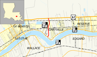
Louisiana Highway 54 (LA 54) is a state highway located in St. John the Baptist Parish, Louisiana. It runs 2.34 miles (3.77 km) in a north–south direction from LA 44 to U.S. Highway 61 (US 61) in Garyville.
Louisiana Highway 73 is a state highway in Louisiana stretching from Geismar to Baton Rouge. LA 73 was built as a bypass to the backbends of River Road. It was soon after bypassed itself in a more complete way with U.S. Route 61.
Louisiana Highway 641 (LA 641) is a state highway in Louisiana that serves St. James Parish. It travels 6.9 miles (11.1 km) in the shape of a capital J, starting northwest, veering northeast, and then turning north, serving the communities of Lutcher and Gramercy and providing a connection to Interstate 10 (I-10) for those towns.
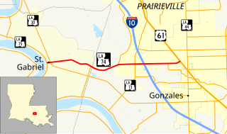
Louisiana Highway 74 (LA 74) is a state highway located in southeastern Louisiana. It runs 10.67 miles (17.17 km) in an east–west direction from LA 75 in St. Gabriel to U.S. Highway 61 (US 61) north of Gonzales.
This page is based on this Wikipedia article Text is available under the CC BY-SA 4.0 license; additional terms may apply. Images, videos and audio are available under their respective licenses.