Louisiana Highway 42

Last updated

Louisiana 42 (2008).svg

Louisiana Highway 42
LA 42 map.svg
Route information
Maintained by Louisiana DOTD
Length 47.8 mi [1] (76.9 km)
Existed 1955 renumbering – present
Major junctions
West endLouisiana 30 (2008).svg LA 30 in Baton Rouge
 

I-10.svg I-10 in Baton Rouge

US 61.svg US 61 in Prairieville
East endLouisiana 22 (2008).svg LA 22 in Springfield
Location
Parishes East Baton Rouge, Ascension, Livingston, Tangipahoa
Highway system
  • Louisiana Highway System
Louisiana 41 (2008).svg LA 41 LA 43 Louisiana 43 (2008).svg

Louisiana Highway 42 (LA 42) is a state highway in Louisiana that serves East Baton Rouge, Ascension, Livingston, and Tangipahoa parishes. It spans 47.8 miles (76.9 km) in a general east–west direction.

A state highway, state road, or state route is usually a road that is either numbered or maintained by a sub-national state or province. A road numbered by a state or province falls below numbered national highways in the hierarchy. Roads maintained by a state or province include both nationally numbered highways and un-numbered state highways. Depending on the state, "state highway" may be used for one meaning and "state road" or "state route" for the other.

Louisiana State of the United States of America

Louisiana is a state in the Deep South region of the South Central United States. It is the 31st most extensive and the 25th most populous of the 50 United States. Louisiana is bordered by the state of Texas to the west, Arkansas to the north, Mississippi to the east, and the Gulf of Mexico to the south. A large part of its eastern boundary is demarcated by the Mississippi River. Louisiana is the only U.S. state with political subdivisions termed parishes, which are equivalent to counties. The state's capital is Baton Rouge, and its largest city is New Orleans.

East Baton Rouge Parish, Louisiana Parish in Louisiana, United States

East Baton Rouge Parish is the most populous parish in the U.S. state of Louisiana. As of the 2010 census, the population was 440,171. The parish seat is Baton Rouge, Louisiana's state capital.

Contents

Route description

From the west, LA 42 starts at an intersection with LA 30 in Baton Rouge near Louisiana State University. It is a four-lane divided highway for 7.6 miles (12.2 km) from LA 30 eastward to an intersection with Highland Road and Siegen Lane in southeastern Baton Rouge. This section is named Burbank Drive. [1]

Louisiana Highway 30 highway in Louisiana

Louisiana Highway 30 (LA 30) is a state highway located in southeastern Louisiana. It runs 28.10 miles (45.22 km) in a northwest to southeast direction from LA 73 in Baton Rouge to the junction of U.S. Highway 61 (US 61) and LA 431 east of Gonzales.

Louisiana State University university in Baton Rouge, Louisiana, USA

Louisiana State University is a public research university in Baton Rouge, Louisiana. The university was founded in 1853 in what is now known as Pineville, Louisiana, under the name Louisiana State Seminary of Learning & Military Academy. The current LSU main campus was dedicated in 1926, consists of more than 250 buildings constructed in the style of Italian Renaissance architect Andrea Palladio, and occupies a 650-acre (2.6 km²) plateau on the banks of the Mississippi River.

From this intersection, LA 42 turns east and follows Highland Road to US 61 (Airline Highway). In this segment, it passes the Highland Road Park and Observatory and the Louisiana Country Club. Curving to the northeast, LA 42 widens to four lanes and passes through an interchange with I-10 (exit 166). [1]

Airline Highway highway in Louisiana

Airline Highway is a divided highway in the U.S. state of Louisiana, built in stages between 1925 and 1953 to bypass the older Jefferson Highway. It runs 115.6 miles (186.0 km), carrying U.S. Highway 61 from New Orleans northwest to Baton Rouge and U.S. Highway 190 from Baton Rouge west over the Mississippi River on the Huey P. Long Bridge. US 190 continues west towards Opelousas on an extension built at roughly the same time.

Interstate 10 (I-10), a major transcontinental Interstate Highway in the Southern United States, runs across the southern part of Louisiana for 274.42 miles (441.64 km). It passes through Lake Charles, Lafayette, and Baton Rouge before dipping south of Lake Pontchartrain to serve the New Orleans metropolitan area before leaving the state.

LA 42 turns southeast and overlaps US 61 out of East Baton Rouge Parish and into Ascension Parish for 3.3 miles (5.3 km). At this point, LA 42 turns eastward and meanders its way across the Amite River and into Livingston Parish, intersecting LA 16 at Port Vincent. For the next 3.1 miles (5.0 km), LA 42 and LA 16 run concurrently into the north end of French Settlement. LA 42 proceeds eastward through rural Livingston Parish until reaching its terminus at LA 22 in the town of Springfield. [1]

Amite River river in the United States of America

The Amite River is a tributary of Lake Maurepas in Mississippi and Louisiana in the United States. It is about 117 miles (188 km) long. It starts as two forks in southwestern Mississippi and flows south through Louisiana, passing Greater Baton Rouge, to Lake Maurepas. The lower 37 miles (59.5 km) of the river is navigable. A portion of the river is diverted via the Petite Amite River and Amite Diversion Canal to the Blind River, which also flows to Lake Maurepas.

Louisiana Highway 16 highway in Louisiana

Louisiana Highway 16 (LA 16) is a state highway located in southeastern Louisiana. It runs 110.27 miles (177.46 km) in a general east–west direction from LA 22 south of French Settlement to LA 21 in Sun.

Port Vincent, Louisiana Village in Louisiana, United States

Port Vincent is a village in Livingston Parish, Louisiana, United States. The population was 741 at the 2010 census. It is part of the Baton Rouge Metropolitan Statistical Area.

Future

Major intersections

ParishLocationmi [1] kmDestinationsNotes
East Baton Rouge Baton Rouge 0.00.0Louisiana 30 (2008).svg LA 30 (Nicholson Drive)Western terminus
4.87.7Spur plate.svg
Louisiana 327 (2008).svg LA 327 Spur south (Gardere Lane)
5.79.2Louisiana 1248 (2008).svg LA 1248 (Bluebonnet Boulevard)
7.612.2Louisiana 3246 (2008).svg LA 3246 north (Siegen Lane)Southern terminus of LA 3246
10.917.5Louisiana 427 (2008).svg LA 427 north (Perkins Road)West end of LA 427 concurrency
11.017.7I-10.svg I-10  Baton Rouge, New Orleans
Kleinpeter 11.318.2Louisiana 427 (2008).svg LA 427 south (Perkins Road East)East end of LA 427 concurrency
12.620.3US 61.svg US 61 north (Airline Highway)
Louisiana 948 (2008).svg LA 948 (Highland Road)
West end of US 61 concurrency; western terminus of LA 948
Ascension 14.924.0Louisiana 427 (2008).svg LA 427 (Perkins Road)
Oak Grove 15.925.6US 61.svg US 61 south (Airline Highway)East end of US 61 concurrency
16.025.7Louisiana 73 (2008).svg LA 73 (Jefferson Highway)
17.728.5Louisiana 930 (2008).svg LA 930 Northern terminus of LA 930
Little Prairie 19.230.9Louisiana 44 (2008).svg LA 44 Western terminus of LA 44
22.836.7Louisiana 933 (2008).svg LA 933 Eastern terminus of LA 933
24.138.8Louisiana 431 (2008).svg LA 431 Northern terminus of LA 431
AscensionLivingston
parish line
Port Vincent 24.238.9Bridge over Amite River
Livingston 24.439.3Louisiana 16 (2008).svg LA 16 west Denham Springs West end of LA 16 concurrency
French Settlement 27.544.3Louisiana 16 (2008).svg LA 16 east French Settlement East end of LA 16 concurrency
Frost 35.056.3Louisiana 63 (2008).svg LA 63 north Livingston
41.967.4Louisiana 441 (2008).svg LA 441 north Holden Southern terminus of LA 441
46.875.3Louisiana 43 (2008).svg LA 43 north Albany Southern terminus of LA 43
Springfield 47.876.9Louisiana 22 (2008).svg LA 22  Ponchatoula
Louisiana 1037 (2008).svg LA 1037
Eastern terminus
1.000 mi = 1.609 km; 1.000 km = 0.621 mi

Related Research Articles

Louisiana Highway 2 highway in Louisiana

Louisiana Highway 2 (LA 2) is a state highway located in northern Louisiana. It runs 189.49 miles (304.95 km) in an east–west direction from the Texas state line southwest of Vivian to a junction with U.S. Highway 65 (US 65) near Lake Providence, just west of the Mississippi state line.

Louisiana Highway 8 highway in Louisiana

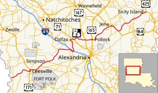
Louisiana Highway 8 is a state highway in Louisiana. It spans 156 miles (251 km) beginning at the Louisiana/Texas state line west of Leesville and ending at an intersection with U.S. Route 425 and LA 15 in Sicily Island.

Louisiana Highway 6 highway in Louisiana

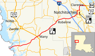
Louisiana Highway 6 (LA 6) is a state highway located in western central Louisiana. It runs 54.52 miles (87.74 km) in an east–west direction from the Texas state line southwest of Many to U.S. Highway 71 (US 71) and U.S. Highway 84 (US 84) in Clarence.

Louisiana Highway 14 highway in Louisiana

Louisiana Highway 14 (LA 14) is a state highway located in southern Louisiana. It runs 100.10 miles (161.10 km) in an east–west direction from the junction of U.S. Highways 90 and 171 in Lake Charles to LA 182 in New Iberia.

Louisiana Highway 22 highway in Louisiana

Louisiana Highway 22 (LA 22) is a state highway located in southeastern Louisiana. It runs 71.15 miles (114.50 km) in a general east–west direction from the junction of LA 75 and LA 942 in Darrow to U.S. Highway 190 (US 190) in Mandeville.

Louisiana Highway 415 highway in Louisiana

Louisiana Highway 415 is a state highway in Louisiana. It spans north–south through West Baton Rouge Parish and Pointe Coupee Parish for 25.3 miles (40.7 km).

Louisiana Highway 73 highway in Louisiana

Louisiana Highway 73 is a state highway in Louisiana stretching from Geismar to Baton Rouge. LA 73 was built as a bypass to the backbends of River Road. It was soon after bypassed itself in a more complete way with U.S. Route 61.

Louisiana Highway 44 highway in Louisiana

Louisiana Highway 44 is a state highway in Louisiana that serves Ascension, St. James, and St. John the Baptist Parishes. It runs from west to east, parallel to the east bank of the Mississippi River, from Prairieville to LaPlace. It spans a total of 50.1 miles (80.6 km). Throughout its run, LA 44 is known as North/South Burnside Avenue, River Road, West/East Jefferson Highway, West 5th Street, and Main Street.

Louisiana Highway 43 highway in Louisiana

Louisiana Highway 43 (LA 43) is a state highway located in southeastern Louisiana. It runs 44.38 miles (71.42 km) in a north–south direction from LA 42 west of Springfield to the Mississippi state line north of Easleyville, where it continues as Mississippi Highway 568 (MS 568).

Louisiana Highway 64 highway in Louisiana

Louisiana Highway 64 (LA 64) is a state highway located in southeastern Louisiana. It runs 20.45 miles (32.91 km) in a general east–west direction from LA 964 in Zachary to the junction of LA 16 and LA 1026 north of Denham Springs.

Louisiana Highway 74 highway in Louisiana

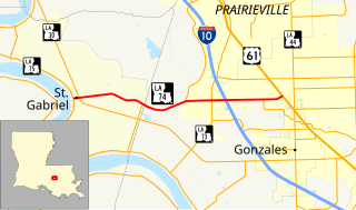
Louisiana Highway 74 (LA 74) is a state highway located in southeastern Louisiana. It runs 10.67 miles (17.17 km) in an east–west direction from LA 75 in St. Gabriel to U.S. Highway 61 (US 61) north of Gonzales.

Louisiana Highway 75 highway in Louisiana

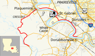
Louisiana Highway 75 (LA 75) is a state highway located in southeastern Louisiana. It runs 46.86 miles (75.41 km) in a general east–west direction from a dead end in Bayou Pigeon to the junction of LA 22 and LA 942 in Darrow.

Louisiana Highway 140 highway in Louisiana

Louisiana Highway 140 (LA 140) is a state highway located in Morehouse Parish, Louisiana. It runs 14.76 miles (23.75 km) in an east–west direction from U.S. Highway 425 (US 425) in Log Cabin to a junction with U.S. Highway 165 (US 165) and LA 599 in Bonita.

Louisiana Highway 425 was a state highway in Louisiana that served East Baton Rouge Parish. It spanned 2.02 miles (3.25 km) in a south to north direction, and was located completely within the city limits of Baton Rouge. It is known as Staring Lane.

References

  1. 1 2 3 4 5 Google (September 16, 2016). "Overview Map of LA 22" (Map). Google Maps . Google. Retrieved September 16, 2016.
KML file (edithelp)
KML is from Wikidata