Gramercy, Louisiana

Last updated
Gramercy
Town
St. James Parish Louisiana Incorporated and Unincorporated areas Gramercy Highlighted.svg
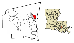
Location of Gramercy in St. James Parish, Louisiana.
Louisiana in United States (US48).svg
Location of Louisiana in the United States
Coordinates: 30°03′14″N90°41′21″W / 30.05389°N 90.68917°W / 30.05389; -90.68917
Country United States
State Louisiana
Parish St. James
Government
  MayorSteven J. Bourgeois (I) [1]
Area
[2]
  Total2.04 sq mi (5.29 km2)
  Land2.01 sq mi (5.21 km2)
  Water0.03 sq mi (0.08 km2)
Elevation
16 ft (5 m)
Population
 (2020)
  Total2,932
  Density1,456.53/sq mi (562.50/km2)
Time zone UTC-6 (CST)
  Summer (DST) UTC-5 (CDT)
Area code 225
FIPS code 22-30550
Website www.townofgramercy.com
Millet House, Gramercy MilletHouse2.JPG
Millet House, Gramercy
Laura Plantation house front near Vacherie Laura Plantation House Front.JPG
Laura Plantation house front near Vacherie

Gramercy is a town in the U.S. state of Louisiana, in St. James Parish. It is part of the New Orleans Metropolitan Area . The population was 3,613 at the time of the 2010 U.S. census and 3,188 according to the 2020 population estimates program. [3]

Contents

History

Gramercy was originally an American Indian and French settlement and trading post. In 1739, much of the area which is now known as Gramercy was sold to Joseph Delille Dupart, Commissioner of Indian Nations under Jean-Baptiste Le Moyne de Bienville. The town was incorporated in November 1947. [4] A historic sugar mill was established in Gramercy in 1895, which became the Colonial Sugar Refinery in 1902. The National Park Service has designated the site as the Colonial Sugar National Historic District. [5]

Geography

Gramercy is located at 30°3′14″N90°41′21″W / 30.05389°N 90.68917°W / 30.05389; -90.68917 (30.053907, -90.689154). [6] The town of Gramercy is bordered on the west by the town of Lutcher and on the south by the Mississippi River. Gramercy is approximately 36 miles west of New Orleans

According to the United States Census Bureau, the town has a total area of 2.1 square miles (5.4 km2), of which 2.1 square miles (5.4 km2) is land and 0.04 square miles (0.10 km2) (1.42%) is water.

Demographics

Historical population
CensusPop.Note
1950 1,184
1960 2,09476.9%
1970 2,56722.6%
1980 3,21125.1%
1990 2,412−24.9%
2000 3,06627.1%
2010 3,61317.8%
2020 2,932−18.8%
U.S. Decennial Census [7]
Gramercy town, Louisiana – Racial and Ethnic Composition
(NH = Non-Hispanic)
Note: the US Census treats Hispanic/Latino as an ethnic category. This table excludes Latinos from the racial categories and assigns them to a separate category. Hispanics/Latinos may be of any race.
Race / EthnicityPop 2000 [8] Pop 2010 [9] Pop 2020 [10] % 2000% 2010% 2020
White alone (NH)1,9351,8471,44863.11%51.12%49.39%
Black or African American alone (NH)1,0651,6731,34834.74%46.31%45.98%
Native American or Alaska Native alone (NH)142070.46%0.55%0.24%
Asian alone (NH)316120.10%0.44%0.41%
Pacific Islander alone (NH)0000.00%0.00%0.00%
Some Other Race alone (NH)0070.00%0.00%0.24%
Mixed Race/Multi-Racial (NH)2721640.88%0.58%2.18%
Hispanic or Latino (any race)2236460.72%1.00%1.57%
Total3,0663,6132,932100.00%100.00%100.00%

As of the 2020 United States census, there were 2,932 people, 1,177 households, and 954 families residing in the town. The 2019 American Community Survey determined the racial and ethnic makeup of the town was 46.8% non-Hispanic white, 52.1% Black and African American, and 1,1% Asian. [11] Of the population, males had a median income of $45,071 versus $38,306 for females. [12] The median household income was $57,750, and 17.7% of the population lived at or below the poverty line.

At the 2000 United States census, [13] there were 3,066 people, 1,090 households, and 833 families residing in the town. The population density was 1,477.6 inhabitants per square mile (570.5/km2). There were 1,163 housing units at an average density of 560.5 per square mile (216.4/km2). The racial makeup of the town was 63.60% White, 34.83% African American, 0.46% Native American, 0.10% Asian, and 1.01% from two or more races. Hispanics or Latin Americans of any race were 0.72% of the population.

In 2000, there were 1,090 households, out of which 35.0% had children under the age of 18 living with them, 53.4% were married couples living together, 18.1% had a female householder with no husband present, and 23.5% were non-families. 20.8% of all households were made up of individuals, and 7.9% had someone living alone who was 65 years of age or older. The average household size was 2.81 and the average family size was 3.27. In the town, the population was spread out, with 28.6% under the age of 18, 7.5% from 18 to 24, 30.0% from 25 to 44, 21.1% from 45 to 64, and 12.7% who were 65 years of age or older. The median age was 35 years. For every 100 females, there were 95.3 males. For every 100 females age 18 and over, there were 89.4 males at the 2000 U.S. census.

In 2000, the median income for a household in the town was $33,824, and the median income for a family was $39,350. Males had a median income of $39,013 versus $22,750 for females. The per capita income for the town was $14,040. About 17.4% of families and 21.3% of the population were below the poverty line, including 29.2% of those under age 18 and 10.0% of those age 65 or over.

Industry

Gramercy is the home of Zapp's Potato Chips and Louisiana Sugar Refining, LLC (LSR). [14]

LSR operates a state-of-the-art sugar refinery with a capacity of 3,100 tons per day. The refinery employs about 150 people. [15] LSR is located in the Colonial Sugars National Historic District. [5]

See also

Related Research Articles

<span class="mw-page-title-main">St. James Parish, Louisiana</span> Parish in Louisiana, United States

St. James Parish is a parish located in the U.S. state of Louisiana. The parish seat is Convent. The parish was created in 1807. St. James Parish is a part of the New Orleans–Metairie, Louisiana metropolitan statistical area, sitting between New Orleans and Baton Rouge on the Mississippi River. According to the 2020 United States census, the population was 20,192.

<span class="mw-page-title-main">Fort Deposit, Alabama</span> Town in Alabama, United States

Fort Deposit is a town in Lowndes County, Alabama, United States. Since 1890, it has been the largest town in Lowndes County. At the 2010 census the population was 1,344, up from 1,270 in 2000. It is part of the Montgomery Metropolitan Statistical Area.

<span class="mw-page-title-main">Mission Hills, Santa Barbara County, California</span> Census-designated place in the U.S. state of California

Mission Hills is a census-designated place (CDP) in Santa Barbara County, California, a short distance north of Lompoc on Highway 1. The population was 3,576 at the 2010 census, up from 3,142 at the 2000 census.

<span class="mw-page-title-main">Poplar-Cotton Center, California</span> Census-designated place in California, United States

Poplar-Cotton Center is a census-designated place (CDP) in Tulare County, California, United States. The population was 2,470 at the 2010 census, up from 1,496 at the 2000 census.

<span class="mw-page-title-main">Clewiston, Florida</span> City in Florida, United States

Clewiston is a city in Hendry County, Florida, United States. Its location is 80 miles (130 km) northwest of Fort Lauderdale on the Atlantic coastal plain. The population was 7,327 at the 2020 census.

<span class="mw-page-title-main">Bonita, Louisiana</span> Village in Louisiana, United States

Bonita is a village in Morehouse Parish, Louisiana, United States. The population was 170 at the 2020 census, down from 284 in 2010.

<span class="mw-page-title-main">Lutcher, Louisiana</span> Town in Louisiana, United States

Lutcher is a town in St. James Parish, Louisiana, United States, on the east bank of the Mississippi River. It is part of the New Orleans Metropolitan Area. The population was 3,559 at the 2010 U.S. census, and 3,127 at the 2020 population estimates program.

North Vacherie is a census-designated place (CDP) in St. James Parish, Louisiana, United States. The population was 2,411 at the 2000 census. Vacherie was noted in the 2000 census as being the town with the least mobility of all in the United States.

South Vacherie is a census-designated place (CDP) in St. James Parish, Louisiana, United States. The population was 3,543 at the 2000 census. In French, the name defines a cattle range for grazing.

Garyville is a census-designated place (CDP) in St. John the Baptist Parish, Louisiana, United States. The population was 2,775 at the 2000 census and 2,123 in 2020. It is part of the New Orleans–Metairie–Kenner Metropolitan Statistical Area.

Reserve is an unincorporated community in St. John the Baptist Parish, Louisiana, United States. It is located on the east bank of the Mississippi River. The population was 9,111 at the 2000 census. For statistical purposes, the United States Census Bureau has defined Reserve as a census-designated place (CDP).

Wallace is a census-designated place (CDP) in St. John the Baptist Parish, Louisiana, United States. The population was 570 at the 2000 census. It is part of the New Orleans–Metairie–Kenner Metropolitan Statistical Area. The rural community is on the west bank of the Mississippi River and easily accessible to Interstate 10 via the Gramercy Bridge.

<span class="mw-page-title-main">Sandersville, Mississippi</span> Town in Mississippi, United States

Sandersville is a town in Jones County, Mississippi, United States. The population was 636 at the 2020 census, down from 731 at the 2010 census. It is part of the Laurel micropolitan area.

<span class="mw-page-title-main">Drayton, North Dakota</span> City in North Dakota, United States

Drayton is a city in Pembina County, North Dakota, United States. The population was 757 at the 2020 census. Drayton was founded in 1878.

<span class="mw-page-title-main">Kenefick, Texas</span> Town in Texas, United States

Kenefick is a town in Liberty County, Texas, United States. The population was 563 at the 2010 census.

<span class="mw-page-title-main">Northfork, West Virginia</span> Town in West Virginia, United States

Northfork is a town in McDowell County, West Virginia, United States, located on U.S. Route 52 between Welch and Bluefield.

<span class="mw-page-title-main">Lynxville, Wisconsin</span> Village in Wisconsin, United States

Lynxville is a village in Crawford County, Wisconsin, United States. The population was 132 at the 2010 census.

<span class="mw-page-title-main">Red Cedar, Wisconsin</span> Town in Wisconsin, United States

Red Cedar is a town in Dunn County, Wisconsin, United States. The population was 1,673 at the 2000 census. The unincorporated communities of Cedar Falls and Rusk are located in the town.

<span class="mw-page-title-main">Fairview, Wyoming</span> Census-designated place in Wyoming, United States

Fairview (CDP) is in Lincoln County, Wyoming, United States. The population was 277 at the 2020 census.

<span class="mw-page-title-main">Sugar Creek, Missouri</span> City in Missouri, United States

Sugar Creek is a city primarily in Jackson County, Missouri with a very small part of the city limits in Clay County, Missouri, United States. The population was 3,271 at the 2020 census. It is part of the Kansas City metropolitan area.

References

  1. "Election Returns: St. James Parish". Louisiana Secretary of State. December 10, 2022. Retrieved June 27, 2022.
  2. "2020 U.S. Gazetteer Files". United States Census Bureau. Retrieved March 20, 2022.
  3. "City and Town Population Totals: 2010-2020". The United States Census Bureau. Retrieved 2021-07-17.
  4. Louisiana Department of Culture, Recreation and Tourism. "Gramercy Historical Marker" . Retrieved August 9, 2009.
  5. 1 2 Colonial Sugar Historic District, National Park Service.
  6. "US Gazetteer files: 2010, 2000, and 1990". United States Census Bureau. 2011-02-12. Retrieved 2011-04-23.
  7. "Census of Population and Housing". Census.gov. Retrieved June 4, 2015.
  8. "P004 HISPANIC OR LATINO, AND NOT HISPANIC OR LATINO BY RACE – 2000: DEC Summary File 1 – Gramercy town, Louisiana". United States Census Bureau .
  9. "P2 HISPANIC OR LATINO, AND NOT HISPANIC OR LATINO BY RACE – 2010: DEC Redistricting Data (PL 94-171) – Gramercy town, Louisiana". United States Census Bureau .
  10. "P2 HISPANIC OR LATINO, AND NOT HISPANIC OR LATINO BY RACE - 2020: DEC Redistricting Data (PL 94-171) – Gramercy town, Louisiana". United States Census Bureau .
  11. "2019 Demographic and Housing Estimates". data.census.gov. Retrieved 2021-07-17.
  12. "Geography Profile: Gramercy town, Louisiana". data.census.gov. Retrieved 2021-07-17.
  13. "U.S. Census website". United States Census Bureau . Retrieved 2008-01-31.
  14. "Zapps". Utz Quality Foods. Retrieved 2021-07-17.
  15. "Louisiana Sugar Refining - Home". www.lsrsugar.com. Retrieved 2021-07-17.