Goodview, Minnesota

Last updated

Goodview
Goodview City Hall.jpg
City hall
Motto: 
"A Great Place To Live"
Winona County Minnesota Incorporated and Unincorporated areas Goodview Highlighted.svg
Location of Goodview, Minnesota
Coordinates: 44°04′15″N91°43′21″W / 44.07083°N 91.72250°W / 44.07083; -91.72250
CountryUnited States
State Minnesota
County Winona
Government
  TypeMayor - Council
  MayorBen Klinger
Area
[1]
  Total
2.48 sq mi (6.41 km2)
  Land2.22 sq mi (5.75 km2)
  Water0.26 sq mi (0.67 km2)
Elevation
[2]
646 ft (197 m)
Population
 (2020) [3]
  Total
4,158
  Estimate 
(2021) [4]
4,138
  Density1,874.66/sq mi (723.65/km2)
Time zone UTC-6 (CST)
  Summer (DST) UTC-5 (CDT)
ZIP code
55987
Area code 507
FIPS code 27-24524 [5]
GNIS feature ID2394931 [2]
Website goodview.govoffice.com

Goodview is a city in Winona County, Minnesota, United States. The population was 4,158 at the 2020 census. [3]

Contents

Geography

Goodview, Minnesota 2.jpg

According to the United States Census Bureau, the city has a total area of 2.49 square miles (6.45 km2); 2.25 square miles (5.83 km2) is land and 0.24 square miles (0.62 km2) is water. [6]

Demographics

Historical population
CensusPop.Note
1950 777
1960 1,34873.5%
1970 1,82935.7%
1980 2,56740.3%
1990 2,87812.1%
2000 3,37317.2%
2010 4,03619.7%
2020 4,1583.0%
2021 (est.)4,138 [4] −0.5%
U.S. Decennial Census [7]
2020 Census [3]

2010 census

As of the census of 2010, there were 4,036 people, 1,660 households, and 1,127 families living in the city. The population density was 1,793.8 inhabitants per square mile (692.6/km2). There were 1,750 housing units at an average density of 777.8 per square mile (300.3/km2). The racial makeup of the city was 96.0% White, 0.8% African American, 0.2% Native American, 1.8% Asian, 0.5% from other races, and 0.7% from two or more races. Hispanic or Latino of any race were 2.1% of the population.

There were 1,660 households, of which 30.2% had children under the age of 18 living with them, 52.0% were married couples living together, 11.9% had a female householder with no husband present, 4.0% had a male householder with no wife present, and 32.1% were non-families. 23.9% of all households were made up of individuals, and 6.8% had someone living alone who was 65 years of age or older. The average household size was 2.41 and the average family size was 2.85.

The median age in the city was 38.7 years. 22.4% of residents were under the age of 18; 9.6% were between the ages of 18 and 24; 26.5% were from 25 to 44; 28% were from 45 to 64; and 13.7% were 65 years of age or older. The gender makeup of the city was 49.4% male and 50.6% female.

2000 census

As of the census of 2000, there were 3,373 people, 1,375 households, and 966 families living in the city. The population density was 1,947.2 inhabitants per square mile (751.8/km2). There were 1,419 housing units at an average density of 819.2 per square mile (316.3/km2). The racial makeup of the city was 97.45% White, 0.39% African American, 0.15% Native American, 1.16% Asian, 0.27% from other races, and 0.59% from two or more races. Hispanic or Latino of any race were 0.95% of the population.

There were 1,375 households, out of which 34.3% had children under the age of 18 living with them, 57.7% were married couples living together, 9.9% had a female householder with no husband present, and 29.7% were non-families. 24.2% of all households were made up of individuals, and 7.6% had someone living alone who was 65 years of age or older. The average household size was 2.45 and the average family size was 2.92.

In the city, the population was spread out, with 25.7% under the age of 18, 8.7% from 18 to 24, 30.1% from 25 to 44, 24.5% from 45 to 64, and 11.0% who were 65 years of age or older. The median age was 36 years. For every 100 females, there were 94.3 males. For every 100 females age 18 and over, there were 92.5 males.

The median income for a household in the city was $43,654, and the median income for a family was $52,837. Males had a median income of $36,788 versus $23,554 for females. The per capita income for the city was $22,488. About 3.8% of families and 6.2% of the population were below the poverty line, including 7.7% of those under age 18 and 6.7% of those age 65 or over.

Transportation

Two Amtrak passenger train services run through Goodview on CPKC tracks, but do not stop. The nearest station is 3 miles (4.8 km) to the east in neighboring Winona, where the long-distance Empire Builder operates between Seattle/Portland and Chicago, and the shorter-distance Borealis operates between Saint Paul and Chicago.

Related Research Articles

<span class="mw-page-title-main">Derby Acres, California</span> Census-designated place in California, United States

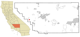
Derby Acres is a census-designated place (CDP) in Kern County, California, United States. Derby Acres is located 5.5 miles (8.9 km) north-northwest of Fellows, at an elevation of 1,375 feet (419 m). The population was 322 at the 2010 census, down from 376 at the 2000 census. The town is on State Route 33 at the northern extremity of the Midway-Sunset Oil Field, about five miles (8 km)five miles southeast of McKittrick.

<span class="mw-page-title-main">Hudson, Iowa</span> City in Iowa, United States

Hudson is a city in Black Hawk County, Iowa, United States. The population was 2,546 at the time of the 2020 census. The rural community of Hudson has grown in recent years and is included as a part of the Waterloo-Cedar Falls Metropolitan Statistical Area.

<span class="mw-page-title-main">Lewis, Iowa</span> City in Iowa, United States

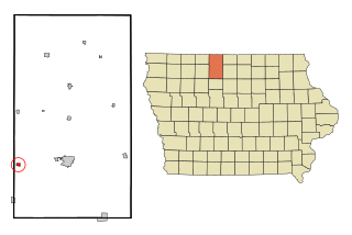
Lewis is a city in Cass County, Iowa, United States, along the East Nishnabotna River. The population was 357 at the time of the 2020 census.

<span class="mw-page-title-main">Hills, Iowa</span> City in Iowa, United States

Hills is a city in Johnson County, Iowa, United States. It is part of the Iowa City, Iowa Metropolitan Statistical Area. The population was 863 at the time of the 2020 census. It is part of the Iowa City Community School District.

<span class="mw-page-title-main">Whittemore, Iowa</span> City in Iowa, United States

Whittemore is a city in Kossuth County, Iowa, United States. The population was 497 at the time of the 2020 census.

<span class="mw-page-title-main">Wapello, Iowa</span> City in Iowa, United States

Wapello is a city in and the county seat of Louisa County, Iowa, United States. The population was 2,084 at the time of the 2020 census.

<span class="mw-page-title-main">Rose Hill, Iowa</span> City in Iowa, United States

Rose Hill is a city in Mahaska County, Iowa, United States. The population was 157 at the time of the 2020 census.

<span class="mw-page-title-main">Crescent, Iowa</span> City in Iowa, United States

Crescent is a city in Pottawattamie County, Iowa, United States. The population was 628 at the 2020 census.

<span class="mw-page-title-main">McClelland, Iowa</span> City in Iowa, United States

McClelland is a city in Pottawattamie County, Iowa, United States. The city was founded in 1903 after the Great Western Railroad was extended to include Council Bluffs. The population was 146 at the time of the 2020 census.

<span class="mw-page-title-main">Manor Creek, Kentucky</span> City in Kentucky, United States

Manor Creek is a home rule-class city in Jefferson County, Kentucky, United States. The population was 140 at the 2010 census, down from 221 at the 2000 census.

<span class="mw-page-title-main">Lake Shore, Minnesota</span> City in Minnesota, United States

Lake Shore is a city in Cass County, Minnesota, United States. The population was 1,056 at the 2020 census. It is part of the Brainerd Micropolitan Statistical Area.

<span class="mw-page-title-main">Ravenwood, Missouri</span> City in Missouri, United States

Ravenwood is a city in eastern Nodaway County, Missouri, United States, near the Platte River. The population was 439 at the 2020 census.

<span class="mw-page-title-main">Green Ridge, Missouri</span> City in Missouri, United States

Green Ridge is a city located along Route 127 in Pettis County, Missouri, United States. The population was 476 at the 2010 census.

<span class="mw-page-title-main">Lake Waukomis, Missouri</span> City in Missouri, United States

Lake Waukomis is a city in Platte County, Missouri and is part of the Kansas City metropolitan area within the United States. The population was 888 at the 2020 census.

<span class="mw-page-title-main">Bella Villa, Missouri</span> City in Missouri, United States

Bella Villa is a city in St. Louis County, Missouri, in the United States. As of the 2010 census, the city population was 729.

<span class="mw-page-title-main">Pasadena Hills, Missouri</span> City in Missouri, United States

Pasadena Hills is a city in St. Louis County, Missouri, United States. The population was 930 at the 2010 census. The entire city is listed on the National Register of Historic Places.

<span class="mw-page-title-main">Clarkson Valley, Missouri</span> City in Missouri, United States

Clarkson Valley is a city in St. Louis County, Missouri, United States. The population was 2,609 at the 2020 census.

<span class="mw-page-title-main">Springdale, Ohio</span> City in Ohio, United States

Springdale is a city in Hamilton County, Ohio, United States. It is a suburb of Cincinnati. The population was 11,007 at the 2020 census.

<span class="mw-page-title-main">Dunes City, Oregon</span> City in Oregon, United States

Dunes City is a city in Lane County, Oregon, United States. The population was 1,303 at the 2010 census.

<span class="mw-page-title-main">Follansbee, West Virginia</span> City in West Virginia, United States

Follansbee is a city in Brooke County, West Virginia, United States, located along the Ohio River. The population was 2,853 at the 2020 census, a decrease from 2,986 at the 2010 census. It is part of the Weirton–Steubenville metropolitan area. The city was named after the Follansbee brothers, the proprietors of a local steel mill.

References

  1. "2020 U.S. Gazetteer Files". United States Census Bureau. Retrieved July 24, 2022.
  2. 1 2 U.S. Geological Survey Geographic Names Information System: Goodview, Minnesota
  3. 1 2 3 "Explore Census Data". United States Census Bureau . Retrieved June 17, 2022.
  4. 1 2 "City and Town Population Totals: 2020-2021". United States Census Bureau. June 16, 2022. Retrieved June 17, 2022.
  5. "U.S. Census website". United States Census Bureau . Retrieved January 31, 2008.
  6. "US Gazetteer files 2010". United States Census Bureau. Archived from the original on January 25, 2012. Retrieved November 13, 2012.
  7. United States Census Bureau. "Census of Population and Housing" . Retrieved October 28, 2014.