Wyattville, Minnesota

Last updated
Wyattville, Minnesota
Unincorporated community
USA Minnesota location map.svg
Red pog.svg
Wyattville, Minnesota
Location of the community of Wyattville
within Warren Township, Winona County
Usa edcp location map.svg
Red pog.svg
Wyattville, Minnesota
Wyattville, Minnesota (the US)
Coordinates: 43°56′27″N91°47′25″W / 43.94083°N 91.79028°W / 43.94083; -91.79028 Coordinates: 43°56′27″N91°47′25″W / 43.94083°N 91.79028°W / 43.94083; -91.79028
Country United States
State Minnesota
County Winona County
Township Warren Township
Elevation 1,247 ft (380 m)
Time zone Central (CST) (UTC-6)
  Summer (DST) CDT (UTC-5)
ZIP code 55952
Area code(s) 507
GNIS feature ID 655024 [1]

Wyattville is an unincorporated community in Warren Township, Winona County, Minnesota, United States.

Unincorporated area Region of land not governed by own local government

In law, an unincorporated area is a region of land that is not governed by a local municipal corporation; similarly an unincorporated community is a settlement that is not governed by its own local municipal corporation, but rather is administered as part of larger administrative divisions, such as a township, parish, borough, county, city, canton, state, province or country. Occasionally, municipalities dissolve or disincorporate, which may happen if they become fiscally insolvent, and services become the responsibility of a higher administration. Widespread unincorporated communities and areas are a distinguishing feature of the United States and Canada. In most other countries of the world, there are either no unincorporated areas at all, or these are very rare; typically remote, outlying, sparsely populated or uninhabited areas.

Warren Township, Winona County, Minnesota Township in Minnesota, United States

Warren Township is a township in Winona County, Minnesota, United States. The population was 651 at the 2010 census.

Winona County, Minnesota county in Minnesota, United States

Winona County is a county in the U.S. state of Minnesota. As of the 2010 census, the population was 51,461. Its county seat is Winona.

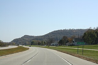
The community is located near the junction of Winona County Roads 12 and 25.

Interstate 90 and State Highway 43 (MN 43) are both nearby. Wyattville had a post office from 1858 to 1902.

In the U.S. state of Minnesota, Interstate 90 traverses the southern side of the state, parallel to the Minnesota-Iowa state line. The route connects the cities of Rochester, Worthington, Albert Lea, and Austin. The city of Winona is also in close proximity to I-90, with about 10 miles away separating the interstate and the city.

Minnesota State Highway 43 highway in Minnesota

Minnesota State Highway 43 is a highway in southeast Minnesota, which runs from its intersection with State Highway 44 in Mabel and continues north to its northern terminus at the Wisconsin state line at Winona, where it becomes Wisconsin Highway 54 upon crossing the Mississippi River.

Nearby places include Lewiston, Wilson, Winona, and Rushford.

Lewiston, Minnesota City in Minnesota, United States

Lewiston is a city in Winona County, Minnesota, United States. The population was 1,620 at the 2010 census.

Wilson, Minnesota Unincorporated community in Minnesota, United States

Wilson is an unincorporated community in Wilson Township, Winona County, Minnesota, United States.

Winona, Minnesota City in Minnesota, United States

Winona is a city in and the county seat of Winona County, in the state of Minnesota. Located in picturesque bluff country on the Mississippi River, its most noticeable physical landmark is Sugar Loaf. The city is named after legendary figure Winona, said to have been the first-born daughter of Chief Wapasha (Wabasha) III. The population was 27,592 at the 2010 census.

Related Research Articles

Homer, Minnesota Census-designated place and Unincorporated community in Minnesota, United States

Homer is an unincorporated community and census-designated place (CDP) in Homer Township, Winona County, Minnesota, United States, on the south bank of the Mississippi River. As of the 2010 census, its population was 181.

Main Channel Bridge (Winona)

Main Channel Bridge (Winona) consists of a pair of bridges, the original cantilever bridge, and a concrete box girder bridge completed in 2016, that span the main channel of the Mississippi River in the United States between Winona, Minnesota, and Latsch Island. Another bridge, the North Channel Bridge, connects the island to rural Buffalo County, Wisconsin. The bridge carries Minnesota State Highway 43, which continues as Wisconsin Highway 54 at the Minnesota/Wisconsin state line on the nearby North Channel Bridge; in Winona, it connects to Winona Street.

South Troy, Minnesota Unincorporated community in Minnesota, United States

South Troy is an unincorporated community in Zumbro Township, Wabasha County, Minnesota, United States. It is located on U.S. Highway 63 about 13 miles north of Rochester. Nearby places include Hammond, Zumbro Falls, Mazeppa, Potsdam, and Oronoco. Wabasha County Roads 7 and 11 are nearby.

Troy, Minnesota Unincorporated community in Minnesota, United States

Troy is an unincorporated community in Saratoga Township, Winona County, Minnesota, United States.

Nodine, Minnesota Unincorporated community in Minnesota, United States

Nodine is an unincorporated community in New Hartford Township, Winona County, Minnesota, United States.

Saratoga, Minnesota Unincorporated community in Minnesota, United States

Saratoga is an unincorporated community in Saratoga Township, Winona County, Minnesota, United States.

Ridgeway, Minnesota Unincorporated community in Minnesota, United States

Ridgeway is an unincorporated community in Pleasant Hill Township, Winona County, Minnesota, United States.

Bethany, Minnesota Unincorporated community in Minnesota, United States

Bethany is an unincorporated community in Norton Township, Winona County, Minnesota, United States.

Clyde, Minnesota Unincorporated community in Minnesota, United States

Clyde is an unincorporated community in Saratoga Township, Winona County, Minnesota, United States.

Fremont, Minnesota Unincorporated community in Minnesota, United States

Fremont is an unincorporated community in Fremont Township, Winona County, Minnesota, United States.

Witoka, Minnesota Unincorporated community in Minnesota, United States

Witoka is an unincorporated community in Winona County, Minnesota, United States.

Pine Creek, Minnesota Unincorporated community in Minnesota, United States

Pine Creek is an unincorporated community in Houston and Winona counties in the U.S. state of Minnesota.

Donehower, Minnesota Unincorporated community in Minnesota, United States

Donehower is an unincorporated community in Richmond Township, Winona County, Minnesota, United States.

Centerville, Winona County, Minnesota Unincorporated community in Minnesota, United States

Centerville is an unincorporated community in Wilson Township, Winona County, Minnesota, United States.

Dresbach, Minnesota Unincorporated community in Minnesota, United States

Dresbach is an unincorporated community in Dresbach Township, Winona County, Minnesota, United States.

Lamoille, Minnesota Unincorporated community in Minnesota, United States

Lamoille is an unincorporated community in Richmond Township, Winona County, Minnesota, United States. Big Trout Creek and the Mississippi River meet at Lamoille.

Pine Creek, Wisconsin Unincorporated community in Wisconsin, United States

Pine Creek is an unincorporated community located in the town of Dodge, Trempealeau County, Wisconsin, United States. Pine Creek is located on Pine Creek and County Highway G 9.6 miles (15.4 km) west-northwest of Galesville.

References