Beaver, Minnesota

Last updated
Beaver
1894PlatMapBeaverMN.jpg
1894 plat map of Beaver
USA Minnesota location map.svg
Red pog.svg
Beaver
Location of the community of Beaver
within Whitewater Township, Winona County
Usa edcp location map.svg
Red pog.svg
Beaver
Beaver (the United States)
Coordinates: 44°09′10.5″N92°01′12″W / 44.152917°N 92.02000°W / 44.152917; -92.02000 Coordinates: 44°09′10.5″N92°01′12″W / 44.152917°N 92.02000°W / 44.152917; -92.02000
Country United States
State Minnesota
County Winona County
Township Whitewater Township
Elevation
709 ft (216 m)
Time zone UTC-6 (Central (CST))
  Summer (DST) UTC-5 (CDT)
ZIP code
55910
Area code(s) 507
GNIS feature ID654592 [1]

Beaver is an unincorporated community in Whitewater Township, Winona County, Minnesota, United States, located near the junction of State Highway 74 and Winona County Road 30. Nearby places include Altura, Elba, Plainview, St. Charles, Weaver, and Whitewater State Park. The Whitewater River and Beaver Creek both flow through the area.

History

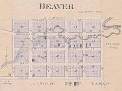
Beaver was settled in 1854, by people from New England. It was the first community established in the Whitewater valley. The name came from observing beavers building dams on the creek that travels through the site to join with the Whitewater River. Following the example of the beavers, the early settlers decided to dam the creek to furnish power for a mill. The community was platted in 1856 by Albert Hopson, Dr. Sheldon Brooks, and William J. Duley, as 20 blocks on 40 acres (160,000 m2). [2] Beaver had a post office from 1857 to 1906. [3] At one time, the community also had a flour mill, hardware store, general store, Methodist church, blacksmith, wagon shop, saloon (maybe two), hotel, school, and cheese factory. However, the farming practices up the hillsides encouraged erosion, and the high hills produced frequent flooding. At first rich soil came down the hillsides when rains came. Then sand from the underlying sandstone was washed down year after year covering everything. Some years because of the flooding the farmers had to plant three times. The flood deposits devastated the area, and today, most of the site is overgrown and much is swampy. In 1932, the state purchased most of the land, buildings were torn down and the Beaver area became a nature reserve. [4]

Eleanor Putnam, age 89 in 2009, a former resident of Beaver during her childhood in the 1920s and 1930s, recalled climbing the hills around Beaver, and how her family farmed the rugged land. She recalled her uncle struggling to climb the hills to farm the top of a plateau, which can be seen in aerial photos. The Beaver Cemetery, just west of the old community center, is where many of the original settlers of Beaver were laid to rest. [5]

Historical population
CensusPop.
1880 86
U.S. Decennial Census [6]

Related Research Articles

Winona County, Minnesota County in Minnesota, United States

Winona County is a county in the U.S. state of Minnesota. As of the 2020 census, its population was 49,671. Its county seat is Winona. Winona County comprises the Winona, MN Micropolitan Statistical Area.

Otselic, New York Town in New York, United States

Otselic is a town in Chenango County, New York, United States, situated on the northern border of Chenango County, northwest of the city of Norwich. The population of the town was 1,054 at the 2010 census. The town is named after a river flowing through it, the Otselic, which is an Oneida word for "place of wild plums". The Otselic valley is the predominant geographic feature in the town, connecting it to the surrounding region north and south.

Kickapoo River

The Kickapoo River is a 126-mile-long (203 km) tributary of the Wisconsin River in the state of Wisconsin, United States. It is named for the Kickapoo Indians who occupied Wisconsin before the influx of white settlers in the early 19th century.

Mahoning River

The Mahoning River is a river located in northeastern Ohio and a small portion of western Pennsylvania. Flowing primarily through several Ohio counties, it crosses the state line into Pennsylvania before joining with the Shenango River to form the Beaver River. The Mahoning River drops from 1,296 feet (395 m) at the headwaters near Winona to 761 feet (232 m) at the outfall near Mahoningtown, Pennsylvania. It is part of the Ohio River watershed.

Whitewater State Park United States historic place

Whitewater State Park is a state park of Minnesota, United States, preserving a stretch of the Whitewater River surrounded by rocky bluffs. It is located in Winona County in the southeastern blufflands area of the state. The 2,700-acre (11 km2) park features scenic overlooks and trout fishing in the spring-fed Whitewater River and Trout Run Creek. It has about 300,000 visitors annually, and is located 7 miles (11 km) north of St. Charles on Minnesota State Highway 74, which runs through the park.

Tohickon Creek River in Pennsylvania, United States

Tohickon Creek is a 29.5-mile-long (47.5 km) tributary of the Delaware River. Located entirely in Bucks County, in southeastern Pennsylvania, it rises in Springfield Township and has its confluence with the Delaware at Point Pleasant. It is dammed to form Lake Nockamixon.

McConnells Mill State Park

McConnells Mill State Park is a 2,546 acres (1,030 ha) Pennsylvania state park in Perry and Slippery Rock Townships, Lawrence County, Pennsylvania in the United States. The park features a deep scenic gorge with the restored watermill and a covered bridge at the bottom, accessible by a roadway that winds between large, room-sized boulders on the hillside. McConnells Mill State Park is along the Slippery Rock Creek. just southwest of the intersection of US 422 and US 19.

Taylorstown is a small community in Loudoun County, Virginia, built on the banks of Catoctin Creek and the surrounding hillside, about two miles (3 km) south of the Potomac River. First settled in 1734, it holds two of the oldest standing houses in Loudoun County, "Hunting Hill" and "Foxton Cottage", directly across the Catoctin Creek from each other.

Salt River (Kentucky)

The Salt River is a 150-mile-long (240 km) river in the U.S. state of Kentucky that drains 2,920 square miles (7,600 km2). It begins near Parksville, Kentucky, rising from the north slope of Persimmon Knob south of KY 300 between Alum Springs and Wilsonville, and ends at the Ohio River near West Point. Taylorsville Lake is formed from the Salt River, and Guist Creek Lake is also in its drainage basin.

Finland, Minnesota Unincorporated community in Minnesota, US

Finland is an unincorporated community and census-designated place (CDP) in Crystal Bay and Beaver Bay townships, Lake County, Minnesota, United States. As of the 2010 census, its population was 195.

Big Sugar Creek is a 47-mile-long (76 km) waterway in the Ozark Mountains of southwest Missouri. The creek starts near the Arkansas state line. Big Sugar starts from three tributaries. One flows north from Garfield, Arkansas, and one, west near Seligman, Missouri, and another, south from Washburn, Missouri. Big Sugar flows west down Sugar Creek Valley, where in the Jacket community it is joined by Otter Creek, from Pea Ridge, Arkansas.

Big Ridge State Park

Big Ridge State Park is a state park in Union County, Tennessee, in the southeastern United States. The park consists of 3,687 acres (14.92 km2) on the southern shore of the Norris Reservoir, an impoundment of the Clinch River created by the completion of Norris Dam in 1936. Much of the park's recreational focus is on Big Ridge Lake, a 45-acre (0.18 km2) sub-impoundment of Norris near the center of the park.

Whitewater River (Minnesota)

The Whitewater River is a 16.6-mile-long (26.7 km) tributary of the Upper Mississippi River which flows through the Driftless Area of Minnesota, reaching its mouth in Wabasha County at the community of Weaver opposite Buffalo, Wisconsin. The nearest towns are Altura, Saint Charles, and Elba. The region hosts endangered native dry oak savannas, semiforested areas that seem to have been dependent on fire for their well-being.

South Fork American River Tributary of the river in Northern California

The South Fork American River is a major tributary of the American River in El Dorado County, California, draining a watershed on the western slope of the Sierra Nevada east of Sacramento. The river begins in pristine Desolation Wilderness and flows through the Sierra Nevada foothills. The river at Coloma was the site of James Marshall's discovery of gold at Sutter's Mill on January 24, 1848, which started the California Gold Rush. The South Fork of the American is "the most popular recreation stream in the West" for whitewater rafting in North America, e.g., 80,000 visitors in 2011.Professional whitewater rafting companies have been offering commercial rafting trips on the South Fork American River since 1978.

Fanno Creek River in Oregon, United States

Fanno Creek is a 15-mile (24 km) tributary of the Tualatin River in the U.S. state of Oregon. Part of the drainage basin of the Columbia River, its watershed covers about 32 square miles (83 km2) in Multnomah, Washington, and Clackamas counties, including about 7 square miles (18 km2) within the Portland city limits.

Middleton is a former town in Montgomery County, Mississippi, United States. Once a thriving commercial and educational center, Middleton was bypassed in 1859 when the Mississippi Central Railway built its line through nearby Winona. Businesses and residents followed the railroad, and Middleton was abandoned. Little remains of the town today but its cemetery, which was restored in 1992 by the Lions Club of Winona.

Beaver Creek State Park State park in Columbiana County, Ohio, USA

Beaver Creek State Park is a 2,722-acre (1,102 ha) public recreation area in Columbiana County, Ohio in the United States. The park is near East Liverpool on the banks of Little Beaver Creek. Remnants of the historic Sandy and Beaver Canal can be found throughout the park. It is open for year-round recreation including, camping, boating, hunting, fishing and hiking.

Monticello was a town in Napa County, California. The site of the settlement is completely covered by Lake Berryessa.

Pickwick, Minnesota Unincorporated community in Minnesota, United States

Pickwick is an unincorporated community in Homer Township, Winona County, Minnesota, United States.

References

  1. "Beaver, Minnesota". Geographic Names Information System . United States Geological Survey.
  2. Minnesota Place Names Archived 2011-06-15 at the Wayback Machine . Minnesota Historical Society. Accessed June 2, 2009.
  3. U.S. Geological Survey Geographic Names Information System: Beaver Post Office (historical)
  4. Jostad, Karen. (1972) "The Buried Town of Beaver." Minnesota State Dept. of Natural Resources, St. Paul. Bureau of Information and Education, ERIC Number: ED072966 (also available in the Minnesota State University Library).
  5. GNIS Data on Beaver Cemetery
  6. United States Census Bureau. "Census of Population and Housing".