Rollingstone, Minnesota

Last updated

Rollingstone
Rollingstone, Minnesota.jpg
Minnesota State Highway 248 runs through town
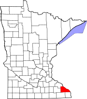
Winona County Minnesota Incorporated and Unincorporated areas Rollingstone Highlighted.svg
Location of Rollingstone, Minnesota
Coordinates: 44°05′58″N91°49′07″W / 44.09944°N 91.81861°W / 44.09944; -91.81861
Country United States
State Minnesota
County Winona
Government
  TypeMayor - Council
  MayorPaul Kreidermacher
Area
[1]
  Total0.43 sq mi (1.13 km2)
  Land0.43 sq mi (1.13 km2)
  Water0.00 sq mi (0.00 km2)
Elevation
[2]
761 ft (232 m)
Population
 (2020)
  Total678
  Density1,558.62/sq mi (601.22/km2)
Time zone UTC-6 (Central (CST))
  Summer (DST) UTC-5 (CDT)
ZIP code
55969
Area code 507
FIPS code 27-55276 [3]
GNIS feature ID2396421 [2]

Rollingstone is a city in Winona County, Minnesota, United States. The population was 678 at the 2020 census.

Contents

History

Rollingstone was founded by immigrants from Luxembourg. [4] The city was named after nearby Rollingstone Creek. [5] Two properties in Rollingstone are listed on the National Register of Historic Places: the 1869 Church of the Holy Trinity and the 1900 Rollingstone Village Hall. [6]

Geography

According to the United States Census Bureau, the city has a total area of 0.48 square miles (1.24 km2), all land. [7]

Demographics

Historical population
CensusPop.Note
1900 202
1910 2051.5%
1920 27232.7%
1930 2896.3%
1940 32412.1%
1950 315−2.8%
1960 39224.4%
1970 45014.8%
1980 52817.3%
1990 69732.0%
2000 6970.0%
2010 664−4.7%
2020 6782.1%
U.S. Decennial Census [8]

2010 census

As of the census [9] of 2010, there were 664 people, 254 households, and 192 families living in the city. The population density was 1,383.3 inhabitants per square mile (534.1/km2). There were 267 housing units at an average density of 556.3 per square mile (214.8/km2). The racial makeup of the city was 98.6% White, 0.3% Native American, 0.9% Asian, and 0.2% from two or more races. Hispanic or Latino of any race were 0.8% of the population.

There were 254 households, of which 35.0% had children under the age of 18 living with them, 63.4% were married couples living together, 7.1% had a female householder with no husband present, 5.1% had a male householder with no wife present, and 24.4% were non-families. 17.7% of all households were made up of individuals, and 9.9% had someone living alone who was 65 years of age or older. The average household size was 2.61 and the average family size was 2.99.

The median age in the city was 41.2 years. 25.3% of residents were under the age of 18; 7.9% were between the ages of 18 and 24; 21.9% were from 25 to 44; 31.6% were from 45 to 64; and 13.1% were 65 years of age or older. The gender makeup of the city was 52.9% male and 47.1% female.

2000 census

As of the census [3] of 2000, there were 697 people, 245 households, and 203 families living in the city. The population density was 1,528.2 inhabitants per square mile (590.0/km2). There were 251 housing units at an average density of 550.3 per square mile (212.5/km2). The racial makeup of the city was 99.43% White, 0.14% African American, 0.14% Native American, 0.14% Asian, 0.14% from other races. Hispanic or Latino of any race were 0.57% of the population.

There were 245 households, out of which 49.4% had children under the age of 18 living with them, 68.6% were married couples living together, 12.2% had a female householder with no husband present, and 17.1% were non-families. 13.5% of all households were made up of individuals, and 7.8% had someone living alone who was 65 years of age or older. The average household size was 2.84 and the average family size was 3.14.

In the city, the population was spread out, with 31.9% under the age of 18, 6.9% from 18 to 24, 30.8% from 25 to 44, 19.8% from 45 to 64, and 10.6% who were 65 years of age or older. The median age was 34 years. For every 100 females, there were 98.6 males. For every 100 females age 18 and over, there were 90.8 males.

The median income for a household in the city was $45,000, and the median income for a family was $49,083. Males had a median income of $34,250 versus $23,750 for females. The per capita income for the city was $17,294. About 1.6% of families and 2.5% of the population were below the poverty line, including 3.6% of those under age 18 and 3.2% of those age 65 or over.

Rollingstone Luxumbourg Heritage Museum in the former city hall OldCityHallRollingstoneMN.jpg
Rollingstone Luxumbourg Heritage Museum in the former city hall

Related Research Articles

<span class="mw-page-title-main">Ramsey, Minnesota</span> City in Minnesota, United States

Ramsey is a suburban city 22 miles (35 km) north-northwest of downtown Minneapolis in Anoka County, Minnesota, United States. The population was 27,646 at the 2020 census. It is a northwest suburb of the Twin Cities.

<span class="mw-page-title-main">Kelliher, Minnesota</span> Town in Minnesota, United States

Kelliher is a city in Beltrami County, Minnesota, United States. The population was 258 at the 2020 census. Minnesota State Highway 72 is the primary route through Kelliher.

<span class="mw-page-title-main">Hanska, Minnesota</span> City in Minnesota, United States

Hanska is a city in Brown County, Minnesota, United States. The population was 402 at the 2010 census.

<span class="mw-page-title-main">Chickamaw Beach, Minnesota</span> City in Minnesota, United States

Chickamaw Beach is a city in Cass County, Minnesota, United States. The population was 114 at the 2010 census. It is part of the Brainerd Micropolitan Statistical Area.

<span class="mw-page-title-main">Pillager, Minnesota</span> City in Minnesota, United States

Pillager is a city in Cass County, Minnesota, United States. It's population was 469 at the 2010 census. It is part of the Brainerd Micropolitan Statistical Area.

<span class="mw-page-title-main">Isanti, Minnesota</span> City in Minnesota, United States

Isanti is a city in Isanti County, Minnesota, United States. The population was 6,804 at the 2020 census. The name Isanti is composed of two Dakota words: isan ("knife") and ati ("camp"), and refers to the Santee Dakota people.

<span class="mw-page-title-main">Nashwauk, Minnesota</span> City in Minnesota, United States

Nashwauk is a city in Itasca County, Minnesota, United States. The population was 983 at the 2010 census.

<span class="mw-page-title-main">Warba, Minnesota</span> City in Minnesota, United States

Warba is a city in Itasca County, Minnesota, United States. The population was 181 at the 2010 census.

<span class="mw-page-title-main">Lancaster, Minnesota</span> City in Minnesota, United States

Lancaster is a city in Kittson County, Minnesota, United States. As of the 2020 census, the city population was 364.

<span class="mw-page-title-main">Racine, Minnesota</span> City in Minnesota, United States

Racine is a city in Racine Township, Mower County, Minnesota, United States. The population was 442 at the 2010 census.

<span class="mw-page-title-main">Erhard, Minnesota</span> City in Minnesota, United States

Erhard is a city in Otter Tail County, Minnesota, United States. The population was 132 at the 2020 census.

<span class="mw-page-title-main">Urbank, Minnesota</span> City in Minnesota, United States

Urbank is a city in Otter Tail County, Minnesota, United States. The population was 52 at the 2020 census.

<span class="mw-page-title-main">Lowry, Minnesota</span> City in Minnesota, United States

Lowry is a city in Pope County, Minnesota, United States. The population was 334 at the 2020 census.

<span class="mw-page-title-main">Sanborn, Minnesota</span> City in Minnesota, United States

Sanborn is a city in Redwood County, Minnesota, United States. The population was 339 at the 2010 census.

<span class="mw-page-title-main">Orr, Minnesota</span> City in Minnesota, United States

Orr is a city in Saint Louis County, Minnesota, United States. The population was 211 at the 2020 census.

<span class="mw-page-title-main">Clarissa, Minnesota</span> City in Minnesota, United States

Clarissa is a city in Todd County, Minnesota, United States. The population was 681 at the 2010 census. It dropped to 261 inhabitants by the 2020 census.

<span class="mw-page-title-main">West Union, Minnesota</span> City in Minnesota, United States

West Union is a city in Todd County, Minnesota, United States. The population was 111 at the 2010 census. By the 2020 Decennial Census the population had declined to 92.

<span class="mw-page-title-main">Grant, Minnesota</span> City in Minnesota, United States

Grant is a city in Washington County, Minnesota, and a suburb of St. Paul. The population was 4,096 at the time of the 2010 census.

<span class="mw-page-title-main">Dakota, Minnesota</span> City in Minnesota, United States

Dakota is a city in Winona County, Minnesota, United States. The population was 295 at the 2020 census.

Rollingstone Township is a township in Winona County, Minnesota, United States. The population was 701 at the 2010 census.

References

  1. "2020 U.S. Gazetteer Files". United States Census Bureau. Retrieved July 24, 2022.
  2. 1 2 U.S. Geological Survey Geographic Names Information System: Rollingstone, Minnesota
  3. 1 2 "U.S. Census website". United States Census Bureau . Retrieved January 31, 2008.
  4. "Rollingstone Luxembourg Heritage Museum". Visit Winona. 2021. Retrieved December 20, 2021.
  5. Upham, Warren (1920). Minnesota Geographic Names: Their Origin and Historic Significance. Minnesota Historical Society. p.  583.
  6. "Minnesota National Register Properties Database". Minnesota Historical Society. 2009. Retrieved December 25, 2017.
  7. "US Gazetteer files 2010". United States Census Bureau. Archived from the original on July 2, 2012. Retrieved November 13, 2012.
  8. "Census of Population and Housing". Census.gov. Retrieved June 4, 2015.
  9. "U.S. Census website". United States Census Bureau . Retrieved November 13, 2012.