Clearwater, Minnesota

Last updated

Clearwater
Cleawatermn.jpg
Wright County Minnesota Incorporated and Unincorporated areas Clearwater Highlighted.svg
Location of the city of Clearwater
within Wright County, Minnesota
Coordinates: 45°24′37″N94°02′41″W / 45.41028°N 94.04472°W / 45.41028; -94.04472
Country United States
State Minnesota
Counties Wright, Stearns
Area
[1]
  Total1.71 sq mi (4.42 km2)
  Land1.57 sq mi (4.06 km2)
  Water0.14 sq mi (0.36 km2)
Elevation
[2]
1,001 ft (305 m)
Population
 (2020)
  Total1,922
  Density1,227.33/sq mi (473.78/km2)
Time zone UTC-6 (Central (CST))
  Summer (DST) UTC-5 (CDT)
ZIP code
55320
Area code 320
FIPS code 27-11800 [3]
GNIS feature ID2393554 [2]
Website www.clearwatercity.com

Clearwater is a city in Stearns and Wright counties in the U.S. state of Minnesota. The population was 1,922 at the 2020 census. [4] Most of the city lies within Wright County.

Contents

The Wright County portion of Clearwater is part of the Minneapolis St. Paul WI Metropolitan Statistical Area, while the small portion in Stearns County is part of the St. Cloud Metropolitan Statistical Area.

The city is situated between the Mississippi and Clearwater Rivers. Interstate 94 and Minnesota State Highway 24 are its two main thoroughfares.

Clearwater is 12 miles south of St. Cloud, 16 miles northwest of Monticello, and 25 miles northwest of Buffalo.

History

Clearwater was platted in 1856, and named after the nearby Clearwater River. [5] A post office has been in operation at Clearwater since 1856. [6] Three properties in Clearwater are listed on the National Register of Historic Places: the 1861 First Congregational Church of Clearwater, the 1863 William W. Webster House, and the 1888 Clearwater Masonic and Grand Army of the Republic Hall. [7]

Geography

According to the United States Census Bureau, the city has a total area of 1.70 square miles (4.40 km2); 1.56 square miles (4.04 km2) is land and 0.14 square miles (0.36 km2) is water. [8]

Demographics

2020 census

As of the census of 2020, there were 1,922 people, 640 households, and 399 families living in the city. The population density was 1,232.1 inhabitants per square mile (475.7/km2). There were 807 housing units at an average density of 517.3 per square mile (199.7/km2). The racial makeup of the city was 93.0% White, 1.1% African American, 0.5% Asian, 0.1% Native American, 1.0% from other races, and 4.2% from two or more races. Hispanic or Latino of any race were 2.2% of the population.

There were 640 households, of which 37.3% had children under the age of 18 living with them, 42.8% were married couples living together, 22.0% had a female householder with no spouse present, 21.3% had a male householder with no spouse present, and 37.7% were non-families. 27.2% of all households were made up of individuals, and 6.3% had someone living alone who was 65 years of age or older. The average household size was 2.49 and the average family size was 3.10.

The median age in the city was 31.8 years. 27.8% of residents were under the age of 18; 9.9% were between the ages of 18 and 24; 31.1% were from 25 to 44; 19.3% were from 45 to 64; and 11.9% were 65 years of age or older. The gender makeup of the city was 48.7% male and 51.3% female.

Historical population
CensusPop.Note
1880 218
1890 24813.8%
1900 2719.3%
1910 31114.8%
1920 3316.4%
1930 212−36.0%
1940 24113.7%
1950 224−7.1%
1960 27422.3%
1970 2822.9%
1980 37934.4%
1990 59757.5%
2000 85843.7%
2010 1,735102.2%
2020 1,92210.8%
U.S. Decennial Census

2010 census

As of the census [9] of 2010, there were 1,735 people, 680 households, and 445 families living in the city. The population density was 1,112.2 inhabitants per square mile (429.4/km2). There were 762 housing units at an average density of 488.5 per square mile (188.6/km2). The racial makeup of the city was 96.3% White, 1.3% African American, 0.5% Native American, 0.3% Asian, 0.3% from other races, and 1.2% from two or more races. Hispanic or Latino of any race were 3.2% of the population.

There were 680 households, of which 40.0% had children under the age of 18 living with them, 47.8% were married couples living together, 11.6% had a female householder with no husband present, 6.0% had a male householder with no wife present, and 34.6% were non-families. 24.4% of all households were made up of individuals, and 4.9% had someone living alone who was 65 years of age or older. The average household size was 2.55 and the average family size was 3.04.

The median age in the city was 29.5 years. 28.2% of residents were under the age of 18; 8.7% were between the ages of 18 and 24; 35.7% were from 25 to 44; 17.3% were from 45 to 64; and 10% were 65 years of age or older. The gender makeup of the city was 49.5% male and 50.5% female.

2000 census

As of the census [3] of 2000, there were 858 people, 327 households, and 223 families living in the city. The population density was 740.9 inhabitants per square mile (286.1/km2). There were 355 housing units at an average density of 306.5 per square mile (118.3/km2). The racial makeup of the city was 97.79% White, 0.12% African American, 0.58% Native American, 0.35% Asian, 0.58% from other races, and 0.58% from two or more races. Hispanic or Latino of any race were 0.82% of the population.

There were 327 households, out of which 37.0% had children under the age of 18 living with them, 53.5% were married couples living together, 11.0% had a female householder with no husband present, and 31.5% were non-families. 24.2% of all households were made up of individuals, and 8.3% had someone living alone who was 65 years of age or older. The average household size was 2.62 and the average family size was 3.15.

In the city, the population was spread out, with 32.4% under the age of 18, 7.5% from 18 to 24, 32.5% from 25 to 44, 18.6% from 45 to 64, and 9.0% who were 65 years of age or older. The median age was 31 years. For every 100 females, there were 98.2 males. For every 100 females age 18 and over, there were 94.0 males.

The median income for a household in the city was $41,696, and the median income for a family was $46,771. Males had a median income of $36,000 versus $25,341 for females. The per capita income for the city was $17,325. About 6.6% of families and 9.3% of the population were below the poverty line, including 9.6% of those under age 18 and 5.5% of those age 65 or over.

Education

Sections of Clearwater in both counties are in the St. Cloud Area School District. [10] [11] Clearwater is zoned to Clear View Elementary School, [12] South Middle School, [13] and Technical Senior High School. [14]

Related Research Articles

<span class="mw-page-title-main">Nez Perce County, Idaho</span> County in Idaho, United States

Nez Perce County is a county located in the U.S. state of Idaho. As of the 2020 census, the population was 42,090. The county seat is Lewiston. The county is named after the Native American Nez Percé tribe. Nez Perce County is part of the Lewiston, Idaho–WA Metropolitan Statistical Area.

<span class="mw-page-title-main">New Hope, Alabama</span> City in Alabama, United States

New Hope is a city in Madison County, Alabama, United States, and is included in the Huntsville-Decatur Combined Statistical Area. As of the 2020 census, the population was 2,889.

<span class="mw-page-title-main">Weippe, Idaho</span> City in Idaho, United States

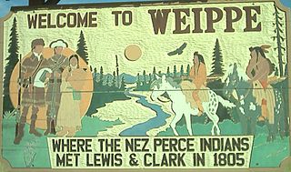
Weippe is a city in Clearwater County, Idaho, United States. The population was 441 at the 2010 census, up from 411 in 2000. In September 1805, the starving Lewis and Clark Expedition first met the Nez Perce on the Weippe Prairie, south of the city.

<span class="mw-page-title-main">Grand River, Iowa</span> City in Iowa, United States

Grand River is a city in northwest Decatur County, Iowa, United States. The population was 196 at the time of the 2020 census.

<span class="mw-page-title-main">Miltonvale, Kansas</span> City in Cloud County, Kansas

Miltonvale is a city in Cloud County, Kansas, United States. As of the 2020 census, the population of the city was 440.

<span class="mw-page-title-main">Clearwater, Kansas</span> City in Sedgwick County, Kansas

Clearwater is a city in Sedgwick County, Kansas, United States. As of the 2020 census, the population of the city was 2,653.

<span class="mw-page-title-main">Bagley, Minnesota</span> City in Minnesota, United States

Bagley is a city in Clearwater County, Minnesota, United States. The population was 1,285 at the 2020 census. It is the county seat of Clearwater County.

<span class="mw-page-title-main">Clearbrook, Minnesota</span> City in Minnesota, United States

Clearbrook is a city in Clearwater County, Minnesota, United States. The population was 464 at the 2020 census.

<span class="mw-page-title-main">Gonvick, Minnesota</span> City in Minnesota, United States

Gonvick is a city in Clearwater County, Minnesota, United States. The population was 263 at the 2020 census. Its peak population was 375 in 1950.

<span class="mw-page-title-main">Clear Lake, Minnesota</span> City in Minnesota, United States

Clear Lake is a city in Sherburne County, Minnesota, United States. The population was 641 at the 2020 census.

<span class="mw-page-title-main">Rockville, Minnesota</span> City in Minnesota, United States

Rockville is a city in Stearns County, Minnesota, United States. The population was 2,448 as of the 2010 census. It is part of the St. Cloud Metropolitan Statistical Area.

<span class="mw-page-title-main">Waite Park, Minnesota</span> City in Minnesota, United States

Waite Park is a city in Stearns County, Minnesota, United States. The population was 8,341 at the 2020 census.

<span class="mw-page-title-main">Nelson, Missouri</span> City in Missouri, United States

Nelson is a city in Saline County, Missouri, United States. The population was 152 at the 2020 census.

<span class="mw-page-title-main">St. John, Missouri</span> City in Missouri, United States

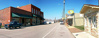
St. John or Saint John is a city in St. Louis County, Missouri, United States, with its commercial district centered along St. Charles Rock Road. It is a few miles southeast of Lambert-St. Louis International Airport.

<span class="mw-page-title-main">Piedmont, Missouri</span> City in Missouri, United States

Piedmont is a city in northwestern Wayne County in Southeast Missouri, United States. Its population was 1,897 at the 2020 census. Part of the Ozark Foothills Region, it is at the convergence of State Highways 34 and 49. Piedmont, transliterated as "foot of the mountain," is named for its position at the foot of Clark Mountain, a 1424-foot summit approximately two miles north of the town.

<span class="mw-page-title-main">Clearwater, Nebraska</span> Village in Antelope County, Nebraska, United States

Clearwater is a village in Antelope County, Nebraska, United States. The population was 419 at the 2010 census.

<span class="mw-page-title-main">Lincoln, North Dakota</span> City in North Dakota, United States

Lincoln is a city in Burleigh County, North Dakota, United States. It is a suburb of adjacent Bismarck, and also a core city of the Bismarck-Mandan Metropolitan Statistical Area. The population was 4,257 at the 2020 census, making it the fourteenth largest city in North Dakota. Lincoln was founded in 1977.

<span class="mw-page-title-main">Clearwater, South Carolina</span> Census-designated place in South Carolina, United States of America

Clearwater is a census-designated place (CDP) in Aiken County, South Carolina. It lies near North Augusta, South Carolina, and is part of the Augusta, Georgia metropolitan area. Clearwater is located in historic Horse Creek Valley. The population was 4,370 at the time of the 2010 census.

<span class="mw-page-title-main">Eden Valley, Minnesota</span> City in Minnesota, United States

Eden Valley is a city in Meeker and Stearns counties in the U.S. state of Minnesota. The population was 1,042 at the 2010 census. Most of Eden Valley is in Meeker County; the Stearns County portion is part of the St. Cloud Metropolitan Statistical Area.

<span class="mw-page-title-main">St. Augusta, Minnesota</span> City in Minnesota, United States

Saint Augusta or St. Augusta, formerly named Ventura, is a city in Stearns County, Minnesota, United States, directly south of the city of St. Cloud. The population was 3,497 at the 2020 census.

References

  1. "2020 U.S. Gazetteer Files". United States Census Bureau. Retrieved July 24, 2022.
  2. 1 2 U.S. Geological Survey Geographic Names Information System: Clearwater, Minnesota
  3. 1 2 "U.S. Census website". United States Census Bureau . Retrieved January 31, 2008.
  4. "U.S. Census website". United States Census Bureau . Retrieved May 29, 2023.
  5. Upham, Warren (1920). Minnesota Geographic Names: Their Origin and Historic Significance. Minnesota Historical Society. p.  587.
  6. "Wright County". Jim Forte Postal History. Archived from the original on November 22, 2015. Retrieved August 1, 2015.
  7. "National Register Information System". National Register of Historic Places . National Park Service. July 9, 2010.
  8. "US Gazetteer files 2010". United States Census Bureau. Archived from the original on July 2, 2012. Retrieved November 13, 2012.
  9. "U.S. Census website". United States Census Bureau . Retrieved November 13, 2012.
  10. "2020 CENSUS - SCHOOL DISTRICT REFERENCE MAP: Wright County, MN" (PDF). U.S. Census Bureau . Retrieved November 7, 2022.
  11. "2020 CENSUS - SCHOOL DISTRICT REFERENCE MAP: Stearns County, MN" (PDF). U.S. Census Bureau . Retrieved November 7, 2022.
  12. "Elementary Attendance Areas" (PDF). St. Cloud Area School District . Retrieved November 8, 2022. - Detail map which is linked from here - Compare to census maps.
  13. "SOUTH Versatrans Base Map" (PDF). St. Cloud Area School District . Retrieved November 8, 2022. - linked from here - Compare to census maps.
  14. "TECH Versatrans Base Map" (PDF). St. Cloud Area School District . Retrieved November 8, 2022. - linked from here - Compare to census maps.