St. Stephen, Minnesota

Last updated

Saint Stephen
Motto: 
"A Place To Call Home"
Stearns County Minnesota Incorporated and Unincorporated areas St. Stephen Highlighted.svg
Location of Saint Stephen
within Stearns County, Minnesota
Coordinates: 45°42′04″N94°16′27″W / 45.70111°N 94.27417°W / 45.70111; -94.27417
CountryUnited States
State Minnesota
County Stearns
Founded1903
Incorporated 1914
Government
   Mayor Lisa Marvin
Area
[1]
  Total3.72 sq mi (9.64 km2)
  Land3.72 sq mi (9.64 km2)
  Water0.00 sq mi (0.00 km2)
Elevation
[2]
1,207 ft (368 m)
Population
 (2020) [3]
  Total797
  Estimate 
(2022) [4]
800
  Density214.13/sq mi (82.67/km2)
Time zone UTC–6 (Central (CST))
  Summer (DST) UTC–5 (CDT)
ZIP Code
56375
Area code 320
FIPS code 27-58090
GNIS feature ID2396521 [2]
Sales tax 7.125% [5]
Website cityofststephen.com

Saint Stephen is a city in Stearns County, Minnesota, United States. The population was 797 at the 2020 census. [3]

Contents

Saint Stephen is part of the Saint Cloud Metropolitan Statistical Area.

History

St. Stephen was incorporated in 1914. [6] The city contains one property listed on the National Register of Historic Places: the 1903 Church of St. Stephen and its 1890 rectory. [7]

Geography

According to the United States Census Bureau, the city has a total area of 3.68 square miles (9.53 km2), all land. [8]

Main routes include Stearns County Roads 2 and 5. Stearns County Roads 1 and 17 are both nearby.

Demographics

Historical population
CensusPop.Note
1920 246
1930 229−6.9%
1940 2477.9%
1950 234−5.3%
1960 27617.9%
1970 33119.9%
1980 45336.9%
1990 60734.0%
2000 86041.7%
2010 851−1.0%
2020 797−6.3%
2022 (est.)800 [4] 0.4%
U.S. Decennial Census [9]
2020 Census [3]

2010 census

As of the census of 2010, there were 851 people, 305 households, and 234 families living in the city. The population density was 231.3 inhabitants per square mile (89.3/km2). There were 316 housing units at an average density of 85.9 per square mile (33.2/km2). The racial makeup of the city was 99.1% White, 0.1% Native American, 0.1% Pacific Islander, and 0.7% from two or more races. Hispanic or Latino of any race were 0.7% of the population.

There were 305 households, of which 42.0% had children under the age of 18 living with them, 65.9% were married couples living together, 6.2% had a female householder with no husband present, 4.6% had a male householder with no wife present, and 23.3% were non-families. 17.7% of all households were made up of individuals, and 6.2% had someone living alone who was 65 years of age or older. The average household size was 2.79 and the average family size was 3.19.

The median age in the city was 36.4 years. 30.1% of residents were under the age of 18; 6.3% were between the ages of 18 and 24; 28.4% were from 25 to 44; 23.9% were from 45 to 64; and 11.2% were 65 years of age or older. The gender makeup of the city was 51.6% male and 48.4% female.

2000 census

As of the census of 2000, there were 860 people, 289 households, and 238 families living in the city. The population density was 233.9 inhabitants per square mile (90.3/km2). There were 294 housing units at an average density of 80.0 per square mile (30.9/km2). The racial makeup of the city was 99.07% White, and 0.93% from two or more races. Hispanic or Latino of any race were 1.05% of the population.

There were 289 households, out of which 51.2% had children under the age of 18 living with them, 73.7% were married couples living together, 4.2% had a female householder with no husband present, and 17.6% were non-families. 14.2% of all households were made up of individuals, and 4.8% had someone living alone who was 65 years of age or older. The average household size was 2.98 and the average family size was 3.31.

In the city, the population was spread out, with 32.9% under the age of 18, 7.0% from 18 to 24, 38.0% from 25 to 44, 15.0% from 45 to 64, and 7.1% who were 65 years of age or older. The median age was 31 years. For every 100 females, there were 108.2 males. For every 100 females age 18 and over, there were 106.1 males.

The median income for a household in the city was $55,078, and the median income for a family was $56,328. Males had a median income of $34,740 versus $25,313 for females. The per capita income for the city was $20,445. About 1.7% of families and 2.8% of the population were below the poverty line, including 2.6% of those under age 18 and 5.1% of those age 65 or over.

Education

Saint Stephen is part of the Sartell-Saint Stephen School District 748. [10]

Related Research Articles

<span class="mw-page-title-main">Stearns County, Minnesota</span> County in Minnesota, United States

Stearns County is a county in the U.S. state of Minnesota. As of the 2020 census, the population was 158,292. Its county seat and largest city is St. Cloud.

Sauk Rapids Township is a township in Benton County, Minnesota, United States near the Mississippi River. The population was 584 at the 2010 census.

Watab Township is an urban township in Benton County, Minnesota, United States, located north of the mouth of Watab Creek on the opposite side of the Mississippi River in Sartell. The population was 3,093 as of the 2010 census.

<span class="mw-page-title-main">Avon, Minnesota</span> City in Minnesota, United States

Avon is a city in Stearns County, Minnesota, United States. The population was 1,396 at the 2010 census. It is part of the St. Cloud Metropolitan Statistical Area.

Brockway Township is a township in Stearns County, Minnesota, United States. The population was 2,701 at the 2010 census. The township includes the City of St. Stephen.

<span class="mw-page-title-main">Collegeville Township, Stearns County, Minnesota</span> Township in Minnesota, United States

Collegeville Township is a township in Stearns County, Minnesota, United States. The population was 3,344 at the 2020 census.

<span class="mw-page-title-main">Greenwald, Minnesota</span> City in Minnesota, United States

Greenwald is a city in Stearns County, Minnesota, United States. The population was 222 at the 2010 census. It is part of the St. Cloud Metropolitan Statistical Area.

<span class="mw-page-title-main">Kimball, Minnesota</span> City in Minnesota, United States

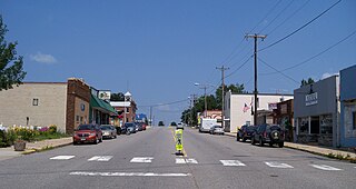
Kimball is a city in Stearns County, Minnesota, United States. The population was 799 at the 2020 census. It is part of the St. Cloud Metropolitan Statistical Area.

<span class="mw-page-title-main">New Munich, Minnesota</span> City in Minnesota, United States

New Munich is a city in Stearns County, Minnesota, United States. The population was 320 at the 2010 census. It is part of the St. Cloud Metropolitan Statistical Area.

<span class="mw-page-title-main">Rockville, Minnesota</span> City in Minnesota, United States

Rockville is a city in Stearns County, Minnesota, United States. The population was 2,448 as of the 2010 census. It is part of the St. Cloud Metropolitan Statistical Area.

<span class="mw-page-title-main">Roscoe, Minnesota</span> City in Minnesota, United States

Roscoe is a city in Stearns County, Minnesota, United States. The population was 102 at the 2010 census. It is part of the St. Cloud Metropolitan Statistical Area. On December 7, 2016, Donald Kennith Albrecht was sworn in as mayor of Roscoe.

St. Joseph Township is a township in Stearns County, Minnesota, United States. The population was 1,924 at the 2010 census. The township borders the western side of the cities of St. Cloud and Waite Park, and completely surrounds the city of St. Joseph. All are components of the St. Cloud Metropolitan Statistical Area.

<span class="mw-page-title-main">St. Martin, Minnesota</span> City in Minnesota, United States

St. Martin or Saint Martin, Smartin to locals, is a city in Stearns County, Minnesota, United States. The population was 308 at the 2010 census. It is part of the St. Cloud Metropolitan Statistical Area.

<span class="mw-page-title-main">St. Rosa, Minnesota</span> City in Minnesota, United States

Saint Rosa is a city in Stearns County, Minnesota, United States. The population was 68 at the 2010 census. It is part of the St. Cloud Metropolitan Statistical Area.

<span class="mw-page-title-main">Waite Park, Minnesota</span> City in Minnesota, United States

Waite Park is a city in Stearns County, Minnesota, United States. The population was 8,341 at the 2020 census.

<span class="mw-page-title-main">St. Anthony, Stearns County, Minnesota</span> City in Minnesota, United States

St. Anthony or Saint Anthony is a city in Stearns County, Minnesota, United States. The population was 86 at the 2010 census. It is part of the St. Cloud Metropolitan Statistical Area. Main routes include Minnesota State Highway 238, Stearns County Road 153, and Trobec Street.

<span class="mw-page-title-main">Sartell, Minnesota</span> City in Minnesota, United States

Sartell is a city in Benton and Stearns Counties in the U.S. state of Minnesota that straddles the Mississippi River. It is part of the St. Cloud Metropolitan Statistical Area. The population was 19,351 at the 2020 census, making it St. Cloud's most populous suburb and the fourth-largest city in central Minnesota, after St. Cloud, Elk River, and Willmar.

<span class="mw-page-title-main">Eden Valley, Minnesota</span> City in Minnesota, United States

Eden Valley is a city in Meeker and Stearns counties in the U.S. state of Minnesota. The population was 1,042 at the 2010 census. Most of Eden Valley is in Meeker County; the Stearns County portion is part of the St. Cloud Metropolitan Statistical Area.

<span class="mw-page-title-main">Brooten, Minnesota</span> City in Minnesota, United States

Brooten is a city in Stearns and Pope counties in the U.S. state of Minnesota, United States. The population was 626 as of the 2020 census. Almost the entire city is within Stearns County, with a small portion in Pope County.

<span class="mw-page-title-main">Clearwater, Minnesota</span> City in Minnesota, United States

Clearwater is a city in Stearns and Wright counties in the U.S. state of Minnesota. The population was 1,922 at the 2020 census. Most of the city lies within Wright County.

References

  1. "2020 U.S. Gazetteer Files". United States Census Bureau. Retrieved July 24, 2022.
  2. 1 2 U.S. Geological Survey Geographic Names Information System: St. Stephen, Minnesota
  3. 1 2 3 "Explore Census Data". United States Census Bureau . Retrieved January 13, 2024.
  4. 1 2 "City and Town Population Totals: 2020-2022". United States Census Bureau. January 13, 2024. Retrieved January 13, 2024.
  5. "St. Stephen (MN) sales tax rate" . Retrieved January 11, 2024.
  6. Upham, Warren (1920). Minnesota Geographic Names: Their Origin and Historic Significance. Minnesota Historical Society. p.  526.
  7. "Minnesota National Register Properties Database". Minnesota Historical Society. 2009. Retrieved June 12, 2018.
  8. "US Gazetteer files 2010". United States Census Bureau. Archived from the original on January 25, 2012. Retrieved November 13, 2012.
  9. United States Census Bureau. "Census of Population and Housing" . Retrieved June 4, 2015.
  10. "Homepage". Sartell - St. Stephen Schools. Retrieved August 9, 2015.