Greenwald | |
---|---|
Coordinates: 45°36′N94°52′W / 45.600°N 94.867°W | |
Country | United States |
State | Minnesota |
County | Stearns |
Area | |
• Total | 0.71 sq mi (1.85 km2) |
• Land | 0.71 sq mi (1.85 km2) |
• Water | 0.00 sq mi (0.00 km2) |
Elevation | 1,266 ft (386 m) |
Population (2020) | |
• Total | 197 |
• Density | 276.30/sq mi (106.72/km2) |
Time zone | UTC-6 (Central (CST)) |
• Summer (DST) | UTC-5 (CDT) |
ZIP code | 56335 |
Area code | 320 |
FIPS code | 27-25874 [3] |
GNIS feature ID | 2394998 [2] |
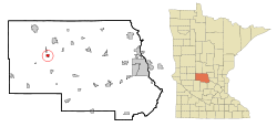
Greenwald is a city in Stearns County, Minnesota, United States. The population was 222 at the 2010 census. [4] It is part of the St. Cloud Metropolitan Statistical Area.
Minnesota State Highway 4 serves as a main route in the community and Interstate 94 passes nearby.
A post office called Greenwald has been in operation since 1910. [5] Greenwald is a name partially derived from German, wald meaning "forest". [6]
According to the United States Census Bureau, the city has a total area of 0.72 square miles (1.86 km2), all land. [7]
The city of Greenwald is located within Grove Township geographically but is a separate entity.
Census | Pop. | Note | %± |
---|---|---|---|
1920 | 153 | — | |
1930 | 237 | 54.9% | |
1940 | 233 | −1.7% | |
1950 | 207 | −11.2% | |
1960 | 266 | 28.5% | |
1970 | 244 | −8.3% | |
1980 | 259 | 6.1% | |
1990 | 209 | −19.3% | |
2000 | 201 | −3.8% | |
2010 | 222 | 10.4% | |
2020 | 197 | −11.3% | |
U.S. Decennial Census [8] |
At the 2010 census, [9] there were 222 people, 98 households and 66 families living in the city. The population density was 308.3 inhabitants per square mile (119.0/km2). There were 104 housing units at an average density of 144.4 per square mile (55.8/km2). The racial makeup of the city was 100.0% White. Hispanic or Latino of any race were 0.9% of the population.
There were 98 households, of which 23.5% had children under the age of 18 living with them, 62.2% were married couples living together, 1.0% had a female householder with no husband present, 4.1% had a male householder with no wife present, and 32.7% were non-families. 29.6% of all households were made up of individuals, and 12.3% had someone living alone who was 65 years of age or older. The average household size was 2.27 and the average family size was 2.77.
The median age was 51.2 years. 20.7% of residents were under the age of 18; 3.7% were between the ages of 18 and 24; 19.8% were from 25 to 44; 34.3% were from 45 to 64; and 21.6% were 65 years of age or older. The gender makeup of the city was 52.7% male and 47.3% female.
At the 2000 census, [3] there were 201 people, 85 households and 61 families living in the city. The population density was 260.2 inhabitants per square mile (100.5/km2). There were 89 housing units at an average density of 115.2 per square mile (44.5/km2). The racial makeup of the city was 100.00% White.
There were 85 households, of which 21.2% had children under the age of 18 living with them, 63.5% were married couples living together, 2.4% had a female householder with no husband present, and 27.1% were non-families. 21.2% of all households were made up of individuals, and 12.9% had someone living alone who was 65 years of age or older. The average household size was 2.36 and the average family size was 2.77.
16.9% of the population were under the age of 18, 11.4% from 18 to 24, 17.9% from 25 to 44, 26.9% from 45 to 64, and 26.9% who were 65 years of age or older. The median age was 46 years. For every 100 females, there were 103.0 males. For every 100 females age 18 and over, there were 103.7 males.
The median household income was $37,000 and the median family income was $42,125. Males had a median income of $31,923 versus $21,071 for females. The per capita income for the city was $17,539. None of the families and 2.4% of the population were living below the poverty line, including no under eighteens and 11.1% of those over 64.
Chickamaw Beach is a city in Cass County, Minnesota, United States. The population was 114 at the 2010 census. It is part of the Brainerd Micropolitan Statistical Area.
Warba is a city in Itasca County, Minnesota, United States. The population was 181 at the 2010 census.
Lake Bronson is a city in Kittson County, Minnesota, United States. The population was 178 at the 2020 census. Lake Bronson State Park is nearby.
Buckman is a city in Morrison County, Minnesota, United States. The population was 307 at the 2020 Census.
Dent is a city in Otter Tail County, Minnesota, United States. The population was 173 at the 2020 census.
Elizabeth is a city in Otter Tail County, Minnesota, United States. The population was 168 at the 2020 census.
Erhard is a city in Otter Tail County, Minnesota, United States. The population was 132 at the 2020 census.
Henning is a city in Otter Tail County, Minnesota, United States. The population was 854 at the 2020 census.
Urbank is a city in Otter Tail County, Minnesota, United States. The population was 52 at the 2020 census.
Henriette, is a city in Pine County, Minnesota, United States. The population was 71 at the 2010 census.
Nielsville is a city in Polk County, Minnesota, United States. It is part of the Grand Forks, ND-MN Metropolitan Statistical Area. The population was 78 at the 2020 census.
Orr is a city in Saint Louis County, Minnesota, United States. The population was 211 at the 2020 census.
Winton is a city in Saint Louis County, Minnesota, United States. The population was 172 at the 2010 census. The city is home to a small hydroelectric dam on the edge of Garden Lake, one of 11 stations owned by Minnesota Power.
Grove Township is a township in Stearns County, Minnesota, United States. The population was 493 at the 2010 census. The township includes the southern one-third of the City of Melrose and the City of Greenwald.
Lake Henry is a city in Stearns County, Minnesota, United States. The population was 103 at the 2010 census. It is part of the St. Cloud Metropolitan Statistical Area.
Campbell is a city in Wilkin County, Minnesota, United States. The population was 164 at the 2020 census. It is part of the Wahpeton, ND-MN Micropolitan Statistical Area.
Minnesota City is a city in Winona County, Minnesota, United States. The population was 202 at the 2020 census.
Genola is a city in Morrison County, Minnesota, United States. The population was 70 at the 2020 census.
Spring Hill is a city in Stearns County, Minnesota, United States. The population was 85 at the 2010 census. It is part of the St. Cloud Metropolitan Statistical Area.
Dennison is a city in Goodhue and Rice counties in the U.S. state of Minnesota. The population was 212 at the 2010 census. Most of Dennison is in Goodhue County, with only a small part that extends into Rice County.