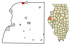
Pontoosuc, Illinois

Last updated

Pontoosuc, Illinois
Hancock County Illinois Incorporated and Unincorporated areas Pontoosuc Highlighted.svg
Location of Pontoosuc in Hancock County, Illinois.
Illinois in United States (US48).svg
Location of Illinois in the United States
Coordinates: 40°37′46″N91°12′35″W / 40.62944°N 91.20972°W / 40.62944; -91.20972
CountryUnited States
StateIllinois
County Hancock
Area
[1]
  Total2.07 sq mi (5.37 km2)
  Land1.41 sq mi (3.64 km2)
  Water0.67 sq mi (1.73 km2)
Elevation
[2]
528 ft (161 m)
Population
 (2020)
  Total99
  Density70.41/sq mi (27.19/km2)
Time zone UTC-6 (CST)
  Summer (DST) UTC-5 (CDT)
ZIP Code(s)
62330 (Dallas City)
Area code 217
FIPS code 17-61080
GNIS feature ID2398998 [2]
Wikimedia CommonsPontoosuc, Illinois

Pontoosuc is a village in Hancock County, Illinois, United States. The population was 99 at the 2020 census. [3]

Contents

Geography

Pontoosuc is located in northern Hancock County at 40°37′46″N91°12′35″W / 40.62944°N 91.20972°W / 40.62944; -91.20972 (40.629520, -91.209603). [4] It is bordered to the north by the Mississippi River, which forms the state border with Iowa, and to the east by Dallas City. Illinois Route 9 passes through the village, leading east into Dallas City and west 5 miles (8 km) to the Fort Madison Toll Bridge over the Mississippi. Illinois Route 96 passes through Pontoosuc concurrently with IL-9 but leads southwest 13 miles (21 km) to Nauvoo.

According to the 2021 census gazetteer files, Pontoosuc has a total area of 2.07 square miles (5.36 km2), of which 1.41 square miles (3.65 km2) (or 67.82%) is land and 0.67 square miles (1.74 km2) (or 32.18%) is water. [5]

Demographics

Historical population
CensusPop.Note
1880 266
1890 249−6.4%
1900 29920.1%
1910 285−4.7%
1920 199−30.2%
1930 143−28.1%
1940 16515.4%
1950 21429.7%
1960 210−1.9%
1970 2267.6%
1980 26115.5%
1990 2641.1%
2000 171−35.2%
2010 146−14.6%
2020 99−32.2%
U.S. Decennial Census [6]

As of the 2020 census [3] there were 99 people, 50 households, and 24 families residing in the village. The population density was 47.76 inhabitants per square mile (18.44/km2). There were 99 housing units at an average density of 47.76 per square mile (18.44/km2). The racial makeup of the village was 95.96% White, 1.01% African American, 0.00% Native American, 0.00% Asian, 0.00% Pacific Islander, 0.00% from other races, and 3.03% from two or more races. Hispanic or Latino of any race were 0.00% of the population.

There were 50 households, out of which 24.0% had children under the age of 18 living with them, 46.00% were married couples living together, 2.00% had a female householder with no husband present, and 52.00% were non-families. 46.00% of all households were made up of individuals, and 18.00% had someone living alone who was 65 years of age or older. The average household size was 3.33 and the average family size was 2.18.

The village's age distribution consisted of 28.4% under the age of 18, 0.0% from 18 to 24, 27.4% from 25 to 44, 21% from 45 to 64, and 22.9% who were 65 years of age or older. The median age was 35.8 years. For every 100 females, there were 98.2 males. For every 100 females age 18 and over, there were 90.2 males.

The median income for a household in the village was $42,500, and the median income for a family was $51,250. Males had a median income of $50,000 versus $28,958 for females. The per capita income for the village was $22,224. About 4.2% of families and 5.5% of the population were below the poverty line, including 9.7% of those under age 18 and 8.0% of those age 65 or over.

Transportation

Amtrak’s Southwest Chief , which operates between Los Angeles and Chicago, passes through the town on BNSF tracks, but makes no stop. The nearest station is located in Fort Madison, 6 miles (9.7 km) to the west.


See also

Related Research Articles

<span class="mw-page-title-main">Coatsburg, Illinois</span> Village in Illinois, United States

Coatsburg is a village in Adams County, Illinois, United States. The population was 150 at the 2020 census. It is part of the Quincy, IL–MO Micropolitan Statistical Area.

<span class="mw-page-title-main">Columbus, Illinois</span> Village in Illinois, United States

Columbus is a village in Adams County, Illinois, United States. The population was 114 at the 2020 census. It is part of the Quincy, IL–MO Micropolitan Statistical Area.

<span class="mw-page-title-main">La Prairie, Illinois</span> Town in Illinois, United States

La Prairie is a village in Adams County, Illinois, United States. The population was 42 at the 2020 census. It is part of the Quincy, IL–MO Micropolitan Statistical Area.

<span class="mw-page-title-main">Loraine, Illinois</span> Village in Illinois, United States

Loraine is a village in Adams County, Illinois, United States. The population was 300 at the 2020 census.

<span class="mw-page-title-main">Ursa, Illinois</span> Village in Illinois, United States

Ursa is a village in Adams County, Illinois, United States. The population was 609 at the 2020 census. It is part of the Quincy, IL–MO Micropolitan Statistical Area.

<span class="mw-page-title-main">Capron, Illinois</span> Village in Illinois, United States

Capron is a village in Boone County, Illinois, United States. It is part of the Rockford, Illinois Metropolitan Statistical Area. The population was 1,395 at the 2020 census, up from 1,376 at the 2010 census.

<span class="mw-page-title-main">Thomasboro, Illinois</span> Village in Illinois, United States

Thomasboro is a village in Champaign County, Illinois, United States. The population was 1,034 at the 2020 census.

<span class="mw-page-title-main">Freeman Spur, Illinois</span> Village in Illinois, United States

Freeman Spur is a village in Williamson and Franklin Counties, Illinois, United States. The population was 268 at the 2020 census.

<span class="mw-page-title-main">Thompsonville, Illinois</span> Village in Illinois, United States

Thompsonville is a village in Cave Township, Franklin County, Illinois, United States. The population was 486 at the 2020 census.

<span class="mw-page-title-main">Greenfield, Illinois</span> City in Illinois, United States

Greenfield is a city in Greene County, Illinois, United States. The population was 1,059 at the 2020 census.

<span class="mw-page-title-main">Godley, Illinois</span> Village in Illinois, United States

Godley is a village in Grundy and Will counties, Illinois, United States. The population was 566 at the 2020 census.

<span class="mw-page-title-main">Augusta, Illinois</span> Village in Illinois, United States

Augusta is a village in southeast Hancock County, Illinois, United States. The population was 553 at the 2020 census. It is located near Weinberg-King State Park.

<span class="mw-page-title-main">Basco, Illinois</span> Village in Illinois, United States

Basco is a village in Bear Creek Township, Hancock County, Illinois, United States. The population was 80 at the 2020 census.

<span class="mw-page-title-main">Bentley, Illinois</span> Town in Illinois, United States

Bentley is an incorporated town in southeast Hancock County, Illinois, United States. The population was 30 at the 2020 census.

<span class="mw-page-title-main">Bowen, Illinois</span> Village in Illinois, United States

Bowen is a village in southeast Hancock County, Illinois, United States. The population was 464 at the 2020 census.

<span class="mw-page-title-main">Elvaston, Illinois</span> Village in Illinois, United States

Elvaston is a village in Hancock County, Illinois, United States. The population was 147 at the 2020 census.

<span class="mw-page-title-main">Ferris, Illinois</span> Village in Illinois, United States

Ferris is a village in Hancock County, Illinois, United States. The population was 127 at the 2020 census.

<span class="mw-page-title-main">Campbell Hill, Illinois</span> Village in Illinois, United States

Campbell Hill is a village in Jackson County, Illinois, United States. The population was 309 at the 2020 census.

<span class="mw-page-title-main">Dana, Illinois</span> Village in Illinois, United States

Dana is a village in LaSalle County, Illinois, United States. As of the 2010 census, the village had a total population of 159, down from 171 in 2000. It is part of the Ottawa Micropolitan Statistical Area, as well as a part of the geographic region known as Streatorland.

<span class="mw-page-title-main">Dorchester, Illinois</span> Village in Illinois, United States

Dorchester is a village in Macoupin County, Illinois, United States. The population was 133 at the 2020 census.

References

  1. "2020 U.S. Gazetteer Files". United States Census Bureau. Retrieved March 15, 2022.
  2. 1 2 U.S. Geological Survey Geographic Names Information System: Pontoosuc, Illinois
  3. 1 2 "Explore Census Data". data.census.gov. Retrieved June 28, 2022.
  4. "US Gazetteer files: 2010, 2000, and 1990". United States Census Bureau. February 12, 2011. Retrieved April 23, 2011.
  5. Bureau, US Census. "Gazetteer Files". Census.gov. Retrieved June 29, 2022.
  6. "Census of Population and Housing". Census.gov. Retrieved June 4, 2015.