Old Niota, Illinois | |
|---|---|
 Old Niota, Illinois  Old Niota, Illinois | |
| Coordinates: 40°36′48″N91°18′08″W / 40.61333°N 91.30222°W | |
| Country | United States |
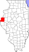
| State | Illinois |
| County | Hancock |
| Elevation | 528 ft (161 m) |
| Time zone | UTC-6 (Central (CST)) |
| • Summer (DST) | UTC-5 (CDT) |
| Area code | 217 |
| GNIS feature ID | 423037 [1] |
Old Niota is an unincorporated community in Hancock County, Illinois, United States. [1] [2]