Coleraine, Minnesota

Last updated

Coleraine
CarnegieLibraryColeraineMN.jpg
Carnegie library at Clemson and Cole Avenues in Coleraine, Minnesota
Itasca County Minnesota Incorporated and Unincorporated areas Coleraine Highlighted.svg
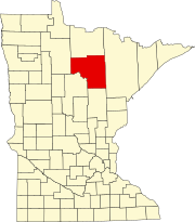
Location of the city of Coleraine
within Itasca County, Minnesota
Coordinates: 47°17′27″N93°25′51″W / 47.29083°N 93.43083°W / 47.29083; -93.43083
Country United States
State Minnesota
County Itasca
Area
[1]
  Total15.84 sq mi (41.03 km2)
  Land15.35 sq mi (39.76 km2)
  Water0.49 sq mi (1.27 km2)
Elevation
[2]
1,325 ft (404 m)
Population
 (2020)
  Total2,006
  Density130.67/sq mi (50.45/km2)
Time zone UTC-6 (Central (CST))
  Summer (DST) UTC-5 (CDT)
ZIP code
55722
Area code 218
FIPS code 27-12502
GNIS feature ID0655778 [2]
Website City of Coleraine MN Web Portal

Coleraine is a city in Itasca County, Minnesota, United States, near Grand Rapids. The population was 2,006 at the 2020 census. [3] The community was named after Thomas F. Cole, President of the Oliver Iron Mining Company.

Contents

U.S. Highway 169 serves as a main route in Coleraine.

History

A post office called Coleraine has been in operation since 1906. [4] The city was named for Thomas F. Cole, a businessperson in the mining industry. [5]

Geography

According to the United States Census Bureau, the city has a total area of 16.64 square miles (43.10 km2), of which 16.13 square miles (41.78 km2) is land and 0.51 square miles (1.32 km2) is water. [6]

The community of Gunn is located within the southern portion of the city of Coleraine.

Demographics

Historical population
CensusPop.Note
1910 1,613
1920 1,300−19.4%
1930 1,243−4.4%
1940 1,3256.6%
1950 1,321−0.3%
1960 1,3461.9%
1970 1,086−19.3%
1980 1,1162.8%
1990 1,041−6.7%
2000 1,1106.6%
2010 1,97077.5%
2020 2,0061.8%
U.S. Decennial Census [7]
2013 Estimate [8]

2010 census

As of the census [9] of 2010, there were 1,970 people, 768 households, and 550 families living in the city. The population density was 122.1 inhabitants per square mile (47.1/km2). There were 831 housing units at an average density of 51.5 per square mile (19.9/km2). The racial makeup of the city was 95.4% White, 0.4% African American, 1.5% Native American, 0.2% Asian, 0.2% from other races, and 2.4% from two or more races. Hispanic or Latino of any race were 1.4% of the population.

There were 768 households, of which 34.4% had children under the age of 18 living with them, 56.0% were married couples living together, 9.5% had a female householder with no husband present, 6.1% had a male householder with no wife present, and 28.4% were non-families. 22.9% of all households were made up of individuals, and 8.7% had someone living alone who was 65 years of age or older. The average household size was 2.54 and the average family size was 2.94.

The median age in the city was 38.8 years. 25.8% of residents were under the age of 18; 7.9% were between the ages of 18 and 24; 24.5% were from 25 to 44; 27.1% were from 45 to 64; and 14.7% were 65 years of age or older. The gender makeup of the city was 50.9% male and 49.1% female.

2000 census

As of the census of 2000, there were 1,110 people, 443 households, and 317 families living in the city. The population density was 178.5 inhabitants per square mile (68.9/km2). There were 462 housing units at an average density of 74.3 per square mile (28.7/km2). The racial makeup of the city was 98.47% White, 0.54% Native American, 0.18% Asian, 0.09% from other races, and 0.72% from two or more races. Hispanic or Latino of any race were 0.81% of the population.

There were 443 households, out of which 32.7% had children under the age of 18 living with them, 59.1% were married couples living together, 9.9% had a female householder with no husband present, and 28.4% were non-families. 23.9% of all households were made up of individuals, and 13.5% had someone living alone who was 65 years of age or older. The average household size was 2.51 and the average family size was 3.00.

In the city, the population was spread out, with 25.9% under the age of 18, 8.5% from 18 to 24, 26.0% from 25 to 44, 22.5% from 45 to 64, and 17.1% who were 65 years of age or older. The median age was 37 years. For every 100 females, there were 98.6 males. For every 100 females age 18 and over, there were 94.6 males.

The median income for a household in the city was $38,681, and the median income for a family was $52,361. Males had a median income of $39,875 versus $22,353 for females. The per capita income for the city was $16,514. About 6.4% of families and 9.8% of the population were below the poverty line, including 10.7% of those under age 18 and 11.2% of those age 65 or over.

Related Research Articles

<span class="mw-page-title-main">Kelliher, Minnesota</span> Town in Minnesota, United States

Kelliher is a city in Beltrami County, Minnesota, United States. The population was 258 at the 2020 census. Minnesota State Highway 72 is the primary route through Kelliher.

<span class="mw-page-title-main">Lake Shore, Minnesota</span> City in Minnesota, United States

Lake Shore is a city in Cass County, Minnesota, United States. The population was 1,056 at the 2020 census. It is part of the Brainerd Micropolitan Statistical Area.

<span class="mw-page-title-main">Felton, Minnesota</span> City in Minnesota, United States

Felton is a city in Clay County, Minnesota, United States. The population was 177 at the 2020 census.

<span class="mw-page-title-main">Bagley, Minnesota</span> City in Minnesota, United States

Bagley is a city in Clearwater County, Minnesota, United States. The population was 1,285 at the 2020 census. It is the county seat of Clearwater County.

<span class="mw-page-title-main">Trommald, Minnesota</span> City in Minnesota, United States

Trommald is a city in Crow Wing County, Minnesota, United States. The population was 99 at the 2020 census. It is part of the Brainerd Micropolitan Statistical Area.

<span class="mw-page-title-main">Bovey, Minnesota</span> City in Minnesota, United States

Bovey is a city in Itasca County, Minnesota, United States. It is part of Minnesota's Iron Range. The population was 829 at the 2020 census.

Grand Rapids Township was a township in Itasca County, Minnesota, United States. The population was 11,747 at the 2000 census. By the time of the 2010 census, the area of the former township had been divided between the cities of Grand Rapids, La Prairie, and Coleraine.

<span class="mw-page-title-main">Marble, Minnesota</span> City in Minnesota, United States

Marble is a city in Itasca County, Minnesota, United States. It is part of the chain of small mining towns known as the Iron Range. The population was 610 at the 2020 census.

<span class="mw-page-title-main">Squaw Lake, Minnesota</span> City in Minnesota, United States

Squaw Lake is a city in Itasca County, Minnesota, United States. The population was 98 at the 2020 census.

<span class="mw-page-title-main">Taconite, Minnesota</span> City in Minnesota, United States

Taconite is a city in Itasca County, Minnesota, United States. The population was 651 at the 2020 census.

<span class="mw-page-title-main">Oslo, Minnesota</span> City in Minnesota, United States

Oslo is a city in Marshall County, Minnesota, United States. The population was 239 at the 2020 census.

<span class="mw-page-title-main">Deer Creek, Minnesota</span> City in Minnesota, United States

Deer Creek is a city in Otter Tail County, Minnesota, United States. The population was 330 at the 2020 census.

<span class="mw-page-title-main">Beltrami, Minnesota</span> City in Minnesota, United States

Beltrami is a city in Polk County, Minnesota, United States and was named in honor of Giacomo Costantino Beltrami, an Italian exile, who traveled to the Red river and the upper Mississippi in 1823. Officially incorporated on September 11, 1901, there had been settlers in the area since 1870. It is part of the Grand Forks, ND-MN Metropolitan Statistical Area. The population was 88 at the 2020 census.

<span class="mw-page-title-main">McIntosh, Minnesota</span> City in Minnesota, United States

McIntosh is a city in Polk County, Minnesota, United States. It is part of the Grand Forks, ND-MN Metropolitan Statistical Area. The population was 606 at the 2020 census.

<span class="mw-page-title-main">Buhl, Minnesota</span> City in Minnesota, United States

Buhl is a city in Saint Louis County, Minnesota, United States. The population was 952 at the 2020 census.

<span class="mw-page-title-main">Cook, Minnesota</span> City in Minnesota, United States

Cook is a city in Saint Louis County, Minnesota, United States. The population was 534 at the 2020 census.

<span class="mw-page-title-main">Hoyt Lakes, Minnesota</span> City in Minnesota, United States

Hoyt Lakes is a city in Saint Louis County, Minnesota. The population was 2,020 at the time of the 2020 census.

<span class="mw-page-title-main">Leonidas, Minnesota</span> City in Minnesota, United States

Leonidas is a city in Saint Louis County, Minnesota, United States. The population was 50 at the 2020 census.

<span class="mw-page-title-main">Winton, Minnesota</span> City in Minnesota, United States

Winton is a city in Saint Louis County, Minnesota, United States. The population was 169 at the 2020 census. The city is home to a small hydroelectric dam on the edge of Garden Lake, one of 11 stations owned by Minnesota Power.

<span class="mw-page-title-main">Wallaceton, Pennsylvania</span> Borough in Pennsylvania, United States

Wallaceton is a borough in Clearfield County, Pennsylvania, United States. The population was 297 at the 2020 census.

References

  1. "2020 U.S. Gazetteer Files". United States Census Bureau. Retrieved July 24, 2022.
  2. 1 2 U.S. Geological Survey Geographic Names Information System: Coleraine, Minnesota
  3. "Coleraine, Minnesota". Census. Retrieved May 31, 2024.
  4. "Itasca County". Jim Forte Postal History. Retrieved July 12, 2015.
  5. Upham, Warren (1920). Minnesota Geographic Names: Their Origin and Historic Significance. Minnesota Historical Society. p.  254.
  6. "US Gazetteer files 2010". United States Census Bureau. Archived from the original on July 2, 2012. Retrieved November 13, 2012.
  7. United States Census Bureau. "Census of Population and Housing" . Retrieved July 14, 2014.
  8. "Population Estimates". United States Census Bureau . Retrieved July 14, 2014.
  9. "U.S. Census website". United States Census Bureau . Retrieved November 13, 2012.

47°17′20″N93°25′40″W / 47.28889°N 93.42778°W / 47.28889; -93.42778