Bois Forte Indian Reservation

Last updated
Flag of the Bois Forte Band of Chippewa Flag of the Bois Forte Band of Chippewa Indians.PNG
Flag of the Bois Forte Band of Chippewa

Bois Forte Indian Reservation is an Indian reservation formed for the Bois Forte Band of Chippewa (or Zagaakwaandagowininiwag (Men of the Thick Woods) in the Ojibwe language).

Contents

Sections

Location of Bois Forte Indian Reservation 0335R Bois Forte Reservation Locator Map.svg
Location of Bois Forte Indian Reservation

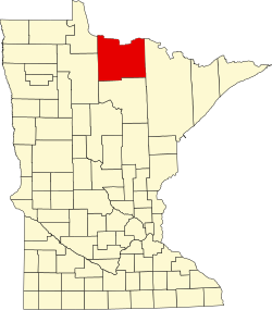
The reservation is composed of three sections in northern Minnesota, United States:

There are additional scattered parcels less than 40 acres (16 ha) in size associated with the reservation. The reservation's total land area is 199.605 sq mi (516.974 km²).

Demographics

As of the census of 2020, [1] the combined population of Bois Forte Reservation and Off-Reservation Trust Land was 984. The population density was 4.9 inhabitants per square mile (1.9/km2). There were 541 housing units at an average density of 2.7 per square mile (1.0/km2). The racial makeup of the reservation and off-reservation trust land was 69.9% Native American, 22.8% White, 0.1% Black or African American, and 7.2% from two or more races. Ethnically, the population was 2.2% Hispanic or Latino of any race.

Broken down by reservation subdivision, the Lake Vermilion segment had 402 people, the Nett Lake segment had 344 people, the Deer Creek segment had 163, and there were 75 people on other trust land parcels. The Bois Forte Indian Reservation is a member of the Minnesota Chippewa Tribe, who in July 2007, reported 3,052 people enrolled in the Bois Forte Band.

History

The community first entered into a treaty with the United States in 1854 that set aside an undefined region around Lake Vermilion as a reservation. The regions at Nett Lake and Itasca County were officially established in an 1866 treaty, and the Lake Vermilion lands were defined in an 1881 executive order. Following the Nelson Act of 1889, the lands were surveyed and subdivided, but the U.S. federal government did not force tribe members to move to the White Earth Indian Reservation. Even so, allotment allowed timber companies and white settlers to acquire much of the land within the reservation boundaries. Only about 41% of the Nett Lake reservation was still tribally-owned by 1981. [2] In 2022, the Conservation Fund returned 28,089 acres (43.889 sq mi; 113.67 km2) of forest land at Nett Lake to the Bois Forte Band. [3]

50% of the reservation is wetland, and the 7,300 acre (30 km²) Nett Lake is said to be the largest producer of wild rice in the United States.

Related Research Articles

Koochiching County, Minnesota County in Minnesota, United States

Koochiching County is a county in the U.S. state of Minnesota. As of the 2020 census, the population was 12,062. Its county seat is International Falls. A portion of the Bois Forte Indian Reservation is in the county. A small part of Voyageurs National Park extends into its boundary, with Lake of the Woods County to its northwest.

Itasca County, Minnesota County in Minnesota, United States

Itasca County is located in the State of Minnesota. As of the 2020 census, the population was 45,014. Its county seat is Grand Rapids. The county is named after Lake Itasca, which is in turn a shortened version of the Latin words veritas caput, meaning 'truth' and 'head', a reference to the source of the Mississippi River. Portions of the Bois Forte and Leech Lake Indian reservations are in the county.

Red Lake Indian Reservation Home to the federally recognized Red Lake Band of Ojibwe

The Red Lake Indian Reservation covers 1,260.3 sq mi in parts of nine counties in northwestern Minnesota, United States. It is made up of numerous holdings but the largest section is an area about Red Lake, in north-central Minnesota, the largest lake in the state. This section lies primarily in the counties of Beltrami and Clearwater. Land in seven other counties is also part of the reservation. The reservation population was 5,506 in the 2020 census.

Lac du Flambeau Band of Lake Superior Chippewa Ojibwa Native American tribe

The Lac du Flambeau Band of Lake Superior Chippewa is a federally recognized Ojibwa Native American tribe. It had 3,415 enrolled members as of 2010. The Lac du Flambeau Indian Reservation lies mostly in the Town of Lac du Flambeau in south-western Vilas County, and in the Town of Sherman in south-eastern Iron County in the U.S. state of Wisconsin. It has a land area of 107.1 square miles (277.4 km2) and a 2020 census resident population of 3,518 persons. Its major settlement is the unincorporated Lac du Flambeau, which had a population of 1,845 persons.

Leech Lake Body of water

Leech Lake is a lake located in north central Minnesota, United States. It is southeast of Bemidji, located mainly within the Leech Lake Indian Reservation, and completely within the Chippewa National Forest. It is used as a reservoir. The lake is the third largest in Minnesota, covering 102,947.83 acres (416.6151 km2) with 195 miles (314 km) of shoreline and has a maximum depth of 156 feet (48 m).

Bad River Band of the Lake Superior Tribe of Chippewa Indians Indian tribe in Wisconsin, United States

The Bad River LaPointe Band of the Lake Superior Tribe of Chippewa Indians or Bad River Tribe for short are a federally recognized tribe of Ojibwe people. The tribe had 6,945 members as of 2010. The Bad River Reservation is located on the south shore of Lake Superior and has a land area of about 193.11 square miles (500.15 km2) in northern Wisconsin, straddling Ashland and Iron counties. Odanah, the administrative and cultural center, is located five miles (8.0 km) east of the town of Ashland on U.S. Highway 2. The reservation population was 1,545 in 2020. Most of the reservation is managed as undeveloped forest and wetland, providing a habitat for wild rice and other natural resources.

White Earth Indian Reservation Anishinaabe / Ojibwe reservation in Minnesota

The White Earth Indian Reservation is the home to the White Earth Band, located in northwestern Minnesota. It is the largest Indian reservation in the state by land area. The reservation includes all of Mahnomen County, plus parts of Becker and Clearwater counties in the northwest part of the state along the Wild Rice and White Earth rivers. It is about 225 miles (362 km) from Minneapolis–Saint Paul and roughly 65 miles (105 km) from Fargo–Moorhead.

Minnesota Chippewa Tribe Governmental authority for six Ojibwe or Anishinaabe bands in Minnesota, US

The Minnesota Chippewa Tribe (MCT) is the centralized governmental authority for six Chippewa bands in the U.S. state of Minnesota. The tribe was created on June 18, 1934; the organization and its governmental powers are divided between the tribe, and the individual bands, which directly operate their reservations. The bands that make up the tribe are:

White Earth Nation

The White Earth Band of the Minnesota Chippewa Tribe, also called the White Earth Nation, is a federally recognized Native American band located in northwestern Minnesota. The band's land base is the White Earth Indian Reservation.

Bois Forte Band of Chippewa

Bois Forte Band of Chippewa are an Ojibwe Band located in northern Minnesota, along the border between the United States and Canada. Their landbase is the Bois Forte Indian Reservation, of which the Nett Lake Indian Reservation holdings are the largest of their reservation holdings. The Bois Forte Band is one of six constituent members of the Minnesota Chippewa Tribe. In 2007, the Minnesota Chippewa Tribe reported having 3,052 people enrolled through the Bois Forte Reservation as members of the Bois Forte Band.

Leech Lake Indian Reservation Indian reservation located in north-central Minnesota

The Leech Lake Reservation is an Indian reservation located in the north-central Minnesota counties of Cass, Itasca, Beltrami, and Hubbard. The reservation forms the land base for the federally recognized Leech Lake Band of Ojibwe, one of six bands comprising the Minnesota Chippewa Tribe, organized in 1934. The Leech Lake Reservation has the highest population of any reservation in Minnesota, with a resident population of 11,388 indicated by the 2020 census.

Mille Lacs Indian Reservation is the popular name for the land-base for the Mille Lacs Band of Ojibwe in Central Minnesota, about 100 miles (160 km) north of Minneapolis-St. Paul. The contemporary Mille Lacs Band reservation has significant land holdings in Mille Lacs, Pine, Aitkin and Crow Wing counties, as well as other land holdings in Kanabec, Morrison, and Otter Tail Counties. Mille Lacs Indian Reservation is also the name of a formal Indian reservation established in 1855. It is one of the two formal reservations on which the contemporary Mille Lacs Band retains land holdings. The contemporary Mille Lacs band includes several aboriginal Ojibwe bands and villages, whose members reside in communities throughout central Minnesota.

Mille Lacs Band of Ojibwe Federally recognized American Indian tribe located in east-central Minnesota

The Mille Lacs Band of Ojibwe, also known as the Mille Lacs Band of Chippewa Indians, is a federally recognized American Indian tribe located in east-central Minnesota. The Band has 4,302 members as of 2012. Its homeland is the Mille Lacs Indian Reservation, consisting of District I, District II, District IIa, and District III.

The Minnesota Indian Affairs Council (MIAC) was created by the Minnesota Legislature in 1963 to provide a liaison between the government of Minnesota and the American Indian tribes in the state. The council also brings issues of concern to Indians living in urban areas to the attention of the state government. It was the first state-level Indian affairs agency to be established in the United States.

Lac Courte Oreilles Band of Lake Superior Chippewa Indians

The Lac Courte Oreilles Tribe is one of six federally recognized bands of Ojibwe people located in present-day Wisconsin. It had 7,275 enrolled members as of 2010. The band is based at the Lac Courte Oreilles Indian Reservation in northwestern Wisconsin, which surrounds Lac Courte Oreilles. The main reservation's land is in west-central Sawyer County, but two small plots of off-reservation trust land are located in Rusk, Burnett, and Washburn counties. The reservation was established in 1854 by the second Treaty of La Pointe.

The Mille Lacs Indians, also known as the Mille Lacs and Snake River Band of Chippewa, are a Band of Indians formed from the unification of the Mille Lacs Band of Mississippi Chippewa (Ojibwe) with the Mille Lacs Band of Mdewakanton Sioux (Dakota). Today, their successor apparent Mille Lacs Band of Ojibwe consider themselves as being Ojibwe, but many on their main reservation have the ma'iingan (wolf) as their chief doodem (clan), which is an indicator of Dakota origins.

The Lake Superior Chippewa are a large number of Ojibwe (Anishinaabe) bands living around Lake Superior; this territory is considered part of northern Michigan, Wisconsin, and Minnesota in the United States. They migrated into the area by the seventeenth century, encroaching on the Eastern Dakota people who historically occupied the area. The Ojibwe defeated the Eastern Dakota and had their last battle in 1745, after which the Dakota Sioux migrated west into the Great Plains. While sharing a common culture and Anishinaabe language, this group of Ojibwe is highly decentralized, with at least twelve independent bands in this region.

Lac Courte Oreilles is a large freshwater lake located in northwest Wisconsin in Sawyer County in townships 39 and 40 north, ranges 8 and 9 west. It is irregular in shape, having numerous peninsulas and bays, and is approximately six miles long in a southwest to northeast direction and with a maximum width of about two miles (3 km). Lac Courte Oreilles is 5,039 acres (20.39 km2) in size with a maximum depth of 90 feet (27 m) and a shoreline of 25.4 miles (40.9 km). The lake has a small inlet stream that enters on the northeast shore of the lake and flows from Grindstone Lake, a short distance away to the north. An outlet on the southeast shore of the lake leads through a very short passage to Little Lac Courte Oreilles, then via the Couderay River to the Chippewa River, and ultimately to the Mississippi River at Lake Pepin.

An act for the relief and civilization of the Chippewa Indians in the State of Minnesota, commonly known as the Nelson Act of 1889, was a United States federal law intended to relocate all the Anishinaabe people in Minnesota to the White Earth Indian Reservation in the western part of the state, and expropriate the vacated reservations for sale to European settlers.

Rainy Lake and River Bands of Saulteaux

Rainy Lake and River Bands of Saulteaux are Saulteaux (Ojibwe) group located in Northwestern Ontario and northern Minnesota, along and about the Rainy Lake and the Rainy River, known in Ojibwe as Gojijiing.

References

  1. "2020 Decennial Census: Bois Forte Reservation and Off-Reservation Trust Land, MN". data.census.gov. U.S. Census Bureau. Retrieved 16 July 2022.
  2. Janke, Ronald A. (1982). "Chippewa Land Losses". Journal of Cultural Geography. 2 (2): 84–100. doi:10.1080/08873638209478619. ISSN   0887-3631 . Retrieved 2022-07-16.
  3. Slater, Brady (7 June 2022). "Nett Lake site of historic return of tribal lands". Duluth News Tribune. Retrieved 16 July 2022.