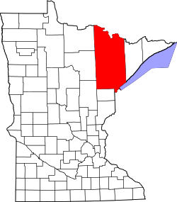
Soudan | |
---|---|
Coordinates: 47°48′57″N92°14′16″W / 47.81583°N 92.23778°W | |
Country | United States |
State | Minnesota |
County | Saint Louis |
Township | Breitung Township |
Area | |
• Total | 0.68 sq mi (1.76 km2) |
• Land | 0.68 sq mi (1.76 km2) |
• Water | 0.00 sq mi (0.00 km2) |
Elevation | 1,437 ft (438 m) |
Population (2020) | |
• Total | 385 |
• Density | 566.18/sq mi (218.61/km2) |
Time zone | UTC-6 (Central (CST)) |
• Summer (DST) | UTC-5 (CDT) |
ZIP codes | 55782 |
Area code | 218 |
GNIS feature ID | 662492 [2] |
Soudan is an unincorporated community and census-designated place (CDP) in Breitung Township, Saint Louis County, Minnesota, United States. As of the 2020 census, its population was 385. [3]
The community is located immediately east of the city of Tower on Minnesota State Highway 1 and Minnesota State Highway 169.
It is the home of McKinley Park, a park and campground operated by Breitung Township, [4] named in honor of former President of the United States, William McKinley, who was in office from 1897 to 1901.
The Soudan Underground Mine State Park is located nearby. The park contains the University of Minnesota's Soudan Underground Laboratory which houses detectors, including MINOS, over 700 meters below the surface of the Earth. Both the mine and the underground laboratory are open for tours.
It has a post office with the ZIP code 55782. [5]
Census | Pop. | Note | %± |
---|---|---|---|
2020 | 385 | — | |
U.S. Decennial Census [6] |
The village of Soudan was established March 3, 1885. Soudan obtained its name from D. H. Bacon, general manager of the Soudan Underground mine. Bacon named the area – with its severe winter cold – Soudan, in strong contrast to the tropical heat of the Soudan (or Sudan) region of Africa. [7] The village had a post office, established as Tower Mines in 1887 and changed to Soudan in 1888; associated with Tower Junction. [8] Soudan has since returned to being an unincorporated community.
The first mining exploration of the area took place in 1865. [9]
According to the 1905 Legislative Manual of the State of Minnesota, the first mining done in northern Minnesota took place at Soudan in 1882. The Duluth & Iron Range Railroad had been built to the area. In 1886 the road was sold to the Minnesota Iron Company, which was absorbed into the Federal Steel Company and then into the United States Steel Corporation (operated by the Oliver Mining Company). [10]
In 1903, the town was described as being located on the property of the mining company and no stores or saloons were allowed. The number of mine workers varied between 500 and 700 men. [11]
Darby Nelson (1940–2022), writer and politician, was born in Soudan. [12]
Westcreek is an unincorporated community and a census-designated place (CDP) located in and governed by Douglas County, Colorado, United States. The CDP is a part of the Denver–Aurora–Lakewood, CO Metropolitan Statistical Area. The population of the Westcreek CDP was 120 at the United States Census 2020. The Sedalia post office serves the area.
Towaoc is a Census-designated place (CDP), a post office, and the capital of the Ute Mountain Ute Tribe located on the Ute Mountain Ute Reservation in Montezuma County, Colorado, United States. The Towaoc post office has the ZIP Code 81334. At the United States Census 2020, the population of the Towaoc CDP was 1,120.
Breitung Township is a township in Saint Louis County, Minnesota, United States. The population was 605 at the 2010 census.
Eagles Nest Township is a township in Saint Louis County, Minnesota, United States. The population was 242 at the 2010 census.
Tower is a city located in Saint Louis County, Minnesota, United States. As of the 2020 census, the city had a total population of 430. State Highways 1, 169, and 135 are three of the main routes in Tower. Tower is located on the southern shore of Lake Vermilion.
The Iron Range is collectively or individually a number of elongated iron-ore mining districts around Lake Superior in the United States and Canada. Much of the ore-bearing region lies alongside the range of granite hills formed by the Giants Range batholith. These cherty iron ore deposits are Precambrian in the Vermilion Range and middle Precambrian in the Mesabi and Cuyuna ranges, all in Minnesota. The Gogebic Range in Wisconsin and the Marquette Iron Range and Menominee Range in Michigan have similar characteristics and are of similar age. Natural ores and concentrates were produced from 1848 until the mid-1950s, when taconites and jaspers were concentrated and pelletized, and started to become the major source of iron production.
Copper Harbor is an unincorporated community and census-designated place (CDP) located in Keweenaw County in the U.S. state of Michigan. It is located within Grant Township. The population of the CDP was 136 as of the 2020 census.
Edward Breitung was a politician from the U.S. state of Michigan. He served one term in the United States House of Representatives from 1883 to 1885.
Rollinsville is a census-designated place (CDP) and post office in and governed by Gilpin County, Colorado, United States. The CDP is a part of the Denver–Aurora–Lakewood, CO Metropolitan Statistical Area. The Rollinsville post office has the ZIP Code 80474. At the United States Census 2020, the population of the Rollinsville CDP was 194.
The Lake Vermilion-Soudan Underground Mine State Park is a Minnesota state park at the site of the Soudan Underground Mine, on the south shore of Lake Vermilion, in the Vermilion Range (Minnesota). The mine is known as Minnesota's oldest, deepest, and richest iron mine. It formerly hosted the Soudan Underground Laboratory. As the Soudan Iron Mine, it has been designated a U.S. National Historic Landmark.
Gold Hill is an unincorporated community and census-designated place (CDP) in southeastern Rowan County, North Carolina, United States near the Cabarrus County line. It was first listed as a CDP in the 2020 census with a population of 372. It is situated near the Yadkin River and is served by U.S. Highway 52 and Old Beatty Ford Road.
Idledale is an unincorporated town, a post office, and a census-designated place (CDP) located in and governed by Jefferson County, Colorado, United States. The CDP is a part of the Denver–Aurora–Lakewood, CO Metropolitan Statistical Area. The Idledale post office has the ZIP code 80453. At the United States Census 2020, the population of the Idledale CDP was 244.
Maybell is an unincorporated community and census-designated place (CDP) in and governed by Moffat County, Colorado, United States. The CDP is a part of the Craig, CO Micropolitan Statistical Area.
Negley is an unincorporated community and census-designated place in Middleton Township, Columbiana County, Ohio, United States. The population was 274 at the 2020 census. Historically a mining community, it lies at the confluence of Bull Creek and the North Fork of the Little Beaver Creek at the state border with Pennsylvania. State Routes 154 and 170 as well as the Youngstown and Southeastern Railroad pass through the community.
Segundo is an unincorporated community and a census-designated place (CDP) located in and governed by Las Animas County, Colorado, United States. The population of the Segundo CDP was 100 at the United States Census 2020. The Trinidad post office serves the area.
White Pine is an unincorporated community and census-designated place (CDP) in Ontonagon County in the U.S. state of Michigan. The CDP had a population of 474 at the 2010 census. White Pine is located within Carp Lake Township.
Lake George is an unincorporated community and census-designated place (CDP) in Lake George Township, Hubbard County, Minnesota, United States. As of the 2010 census, its population was 230.
Gamerco, also called in Navajo: Łigaiyaaʼáhí, is an unincorporated community in McKinley County, New Mexico, United States. As of the 2010 Census, the community population was 1,956. Gamerco was used as a base for coal mining until the 1960s.
Elcor is a ghost town, or more properly, an extinct town, in the U.S. state of Minnesota that was inhabited between 1897 and 1956. It was built on the Mesabi Iron Range near the city of Gilbert in St. Louis County. Elcor was its own unincorporated community before it was abandoned and was never a neighborhood proper of the city of Gilbert. Not rating a figure in the national census, the people of Elcor were only generally considered to be citizens of Gilbert. The area where Elcor was located was annexed by Gilbert when its existing city boundaries were expanded after 1969.
The Stuntz Bay Boathouse Historic District comprises a row of 143 boathouses on Lake Vermilion in Breitung Township, Minnesota, United States. They were mostly built in the first half of the 20th century by employees of the adjacent Soudan Iron Mine. The mining company provided the lots to employees as a reward for their years of service, and the miners did their own construction. Most of the boathouses were built with tamarack logs and scrap corrugated metal from the mine property. Boating and fishing were major pastimes for the mine employees and their families in their leisure hours, and the mining company promoted access to outdoor recreation as a perk of employment. The Stuntz Bay Boathouses were listed as a historic district on the National Register of Historic Places in 2007 for their local significance in the themes of architecture, entertainment/recreation, industry, and social history. They were nominated for illustrating the personal lives of the miners and vernacular metal architecture.