Leonidas, Minnesota

Last updated

Leonidas
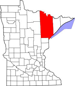
St. Louis County Minnesota Incorporated and Unincorporated areas Leonidas Highlighted.svg
Location of the city of Leonidas
within Saint Louis County, Minnesota
Coordinates: 47°28′5″N92°34′5″W / 47.46806°N 92.56806°W / 47.46806; -92.56806
Country United States
State Minnesota
County Saint Louis
Area
[1]
  Total1.38 sq mi (3.58 km2)
  Land1.33 sq mi (3.43 km2)
  Water0.06 sq mi (0.15 km2)
Elevation
[2]
1,440 ft (440 m)
Population
 (2020)
  Total50
  Density37.71/sq mi (14.56/km2)
Time zone UTC-6 (Central (CST))
  Summer (DST) UTC-5 (CDT)
Area code 218
FIPS code 27-36530 [3]
GNIS feature ID0661705 [2]

Leonidas is a city in Saint Louis County, Minnesota, United States. The population was 52 at the 2010 census. [4]

Contents

Saint Louis County Roads 101 and 755, 1st Street, and 13th Avenue West are the main routes in the community. The city of Leonidas is located immediately west of the city of Eveleth.

Geography

According to the United States Census Bureau, the city has a total area of 1.44 square miles (3.73 km2); 1.28 square miles (3.32 km2) is land and 0.16 square miles (0.41 km2) is water. [5]

Leonidas is adjacent to the neighborhood of West Eveleth.

Demographics

Historical population
CensusPop.Note
1920 457
1930 4999.2%
1940 440−11.8%
1950 88−80.0%
1960 946.8%
1970 15767.0%
1980 95−39.5%
1990 70−26.3%
2000 60−14.3%
2010 52−13.3%
2020 50−3.8%
U.S. Decennial Census [6]

47°27′42″N92°34′19″W / 47.46167°N 92.57194°W / 47.46167; -92.57194

2010 census

As of the census [7] of 2010, there were 52 people, 24 households, and 13 families living in the city. The population density was 40.6 inhabitants per square mile (15.7/km2). There were 27 housing units at an average density of 21.1 per square mile (8.1/km2). The racial makeup of the city was 96.2% White, 1.9% Native American, and 1.9% from two or more races.

There were 24 households, of which 25.0% had children under the age of 18 living with them, 50.0% were married couples living together, 4.2% had a female householder with no husband present, and 45.8% were non-families. 37.5% of all households were made up of individuals, and 8.3% had someone living alone who was 65 years of age or older. The average household size was 2.17 and the average family size was 2.92.

The median age in the city was 46.5 years. 21.2% of residents were under the age of 18; 3.7% were between the ages of 18 and 24; 23% were from 25 to 44; 40.3% were from 45 to 64; and 11.5% were 65 years of age or older. The gender makeup of the city was 48.1% male and 51.9% female.

2000 census

As of the census of 2000, [3] there were 60 people, 26 households, and 19 families living in the city. The population density was 45.1 inhabitants per square mile (17.4/km2). There were 27 housing units at an average density of 20.3 per square mile (7.8/km2). The racial makeup of the city was 98.33% White, and 1.67% from two or more races. 55.9% were of Swedish, 17.6% German and 11.8% Finnish ancestry.

There were 26 households, out of which 34.6% had children under the age of 18 living with them, 57.7% were married couples living together, 3.8% had a female householder with no husband present, and 26.9% were non-families. 15.4% of all households were made up of individuals, and 7.7% had someone living alone who was 65 years of age or older. The average household size was 2.31 and the average family size was 2.58.

In the city, the population was spread out, with 23.3% under the age of 18, 10.0% from 18 to 24, 23.3% from 25 to 44, 30.0% from 45 to 64, and 13.3% who were 65 years of age or older. The median age was 42 years. For every 100 females, there were 100.0 males. For every 100 females age 18 and over, there were 100.0 males.

The median income for a household in the city was $19,167, and the median income for a family was $19,583. Males had a median income of $31,250 versus $40,000 for females. The per capita income for the city was $15,023. There were 20.0% of families and 14.3% of the population living below the poverty line, including 10.0% of under eighteens and 14.3% of those over 64.

Related Research Articles

<span class="mw-page-title-main">Hudson, Iowa</span> City in Iowa, United States

Hudson is a city in Black Hawk County, Iowa, United States. The population was 2,546 at the time of the 2020 census. The rural community of Hudson has grown in recent years and is included as a part of the Waterloo-Cedar Falls Metropolitan Statistical Area.

<span class="mw-page-title-main">Shell Rock, Iowa</span> City in Iowa, United States

Shell Rock is a city in Butler County, Iowa, United States, along the Shell Rock River. The population was 1,268 at the time of the 2020 census. The city is located along the county's eastern border, between Butler and Bremer counties.

<span class="mw-page-title-main">Bassett, Iowa</span> City in Iowa, United States

Bassett is a city in Chickasaw County, Iowa, United States. The population was 45 at the 2020 census.

<span class="mw-page-title-main">Maynard, Iowa</span> City in Iowa, United States

Maynard is a city in Fayette County, Iowa, United States. The population was 476 at the time of the 2020 census.

<span class="mw-page-title-main">Rudd, Iowa</span> City in Iowa, United States

Rudd is a city in Floyd County, Iowa, United States. The population was 358 at the time of the 2020 census, a decline of 16.9% from 431 in 2000.

<span class="mw-page-title-main">Oakland Acres, Iowa</span> City in Iowa, United States

Oakland Acres is a city in Jasper County, Iowa, United States. The population was 176 at the time of the 2020 census.

<span class="mw-page-title-main">Vining, Iowa</span> City in Iowa, United States

Vining is a city in Tama County, Iowa, United States. The population was 54 at the time of the 2020 census.

<span class="mw-page-title-main">Rives Township, Michigan</span> Civil township in Michigan, United States

Rives Township is a civil township of Jackson County in the U.S. state of Michigan. The population was 4,683 at the 2010 census.

Wells Township is a civil township of Tuscola County in the U.S. state of Michigan. The population was 1,773 at the 2010 Census.

Clinton Township is a township in Saint Louis County, Minnesota, United States. Clinton Township was named for Clinton Markell, a prominent settler. The population was 1,015 at the 2010 census.

Fayal Township is an urban township in Saint Louis County, Minnesota, United States. The population was 1,809 at the 2010 census.

<span class="mw-page-title-main">Gilbert, Minnesota</span> City in Minnesota, United States

Gilbert is a city in St. Louis County, Minnesota, United States. The population was 1,799 at the 2010 census. State Highway 37 and State Highway 135 are two of the main routes in Gilbert. Gilbert is part of the Quad Cities, with Virginia, Eveleth, and Mountain Iron. The city is named for Giles Gilbert, who led the exploration of the McKinley mine property in the 1890s.

<span class="mw-page-title-main">Iron Junction, Minnesota</span> City in Minnesota, United States

Iron Junction is a city in Saint Louis County, Minnesota, United States. The population was 86 at the 2010 census.

<span class="mw-page-title-main">Mountain Iron, Minnesota</span> City in Minnesota, United States

Mountain Iron is a city in Saint Louis County, Minnesota, United States, in the heart of the Mesabi Range. The population was 2,878 at the 2020 census.

Leonidas Township is a civil township of St. Joseph County in the U.S. state of Michigan. The population was 1,239 at the 2000 census.

<span class="mw-page-title-main">Rushsylvania, Ohio</span> Village in Ohio, United States

Rushsylvania is a village located in Logan County, Ohio, United States. The population was 491 at the 2020 census.

<span class="mw-page-title-main">Harrisburg, Oregon</span> City in Oregon, United States

Harrisburg is a city in Linn County, Oregon, United States. The population was 3,567 at the 2010 census.

<span class="mw-page-title-main">Granton, Wisconsin</span> Village in Wisconsin, United States

Granton is a village in Clark County in the U.S. state of Wisconsin. The population was 355 at the 2010 census.

<span class="mw-page-title-main">Bay City, Wisconsin</span> Village in Wisconsin, United States

Bay City is a village on the Mississippi River in Pierce County, Wisconsin, United States. The population was 500 at the 2010 census.

Trempealeau is a town in Trempealeau County, Wisconsin, United States. The population was 1,618 at the 2000 census. The town surrounds the village of Trempealeau. The unincorporated communities of Centerville, West Prairie, and Wrights Corners are in the town.

References

  1. "2020 U.S. Gazetteer Files". United States Census Bureau. Retrieved July 24, 2022.
  2. 1 2 U.S. Geological Survey Geographic Names Information System: Leonidas, Minnesota
  3. 1 2 "U.S. Census website". United States Census Bureau . Retrieved January 31, 2008.
  4. "2010 Census Redistricting Data (Public Law 94-171) Summary File". American FactFinder. U.S. Census Bureau, 2010 Census. Retrieved April 23, 2011.[ dead link ]
  5. "US Gazetteer files 2010". United States Census Bureau. Archived from the original on January 25, 2012. Retrieved November 13, 2012.
  6. "Census of Population and Housing". Census.gov. Retrieved June 4, 2015.
  7. "U.S. Census website". United States Census Bureau . Retrieved November 13, 2012.