Cherry, Minnesota

Last updated
Cherry, Minnesota
USA Minnesota location map.svg
Red pog.svg
Cherry, Minnesota
Location of the community of Cherry
within Cherry Township, Saint Louis County
Usa edcp location map.svg
Red pog.svg
Cherry, Minnesota
Cherry, Minnesota (the US)
Coordinates: 47°24′03″N92°42′26″W / 47.40083°N 92.70722°W / 47.40083; -92.70722 Coordinates: 47°24′03″N92°42′26″W / 47.40083°N 92.70722°W / 47.40083; -92.70722
Country United States
State Minnesota
County Saint Louis
Township Cherry Township
Elevation
1,352 ft (412 m)
Population
  Total70
Time zone UTC-6 (Central (CST))
  Summer (DST) UTC-5 (CDT)
ZIP code
55751
Area code(s) 218
GNIS feature ID660988 [1]

Cherry is an unincorporated community in Cherry Township, Saint Louis County, Minnesota, United States.

Unincorporated area Region of land not governed by own local government

In law, an unincorporated area is a region of land that is not governed by a local municipal corporation; similarly an unincorporated community is a settlement that is not governed by its own local municipal corporation, but rather is administered as part of larger administrative divisions, such as a township, parish, borough, county, city, canton, state, province or country. Occasionally, municipalities dissolve or disincorporate, which may happen if they become fiscally insolvent, and services become the responsibility of a higher administration. Widespread unincorporated communities and areas are a distinguishing feature of the United States and Canada. In most other countries of the world, there are either no unincorporated areas at all, or these are very rare; typically remote, outlying, sparsely populated or uninhabited areas.

Cherry Township, St. Louis County, Minnesota Township in Minnesota, United States

Cherry Township is a township in Saint Louis County, Minnesota, United States. The population was 860 at the 2010 census.

St. Louis County, Minnesota County in the United States

St. Louis County is a county located in the northeastern part of the U.S. state of Minnesota. As of the 2010 census, the population was 200,226. Its county seat is Duluth. It is the largest county by total area in Minnesota, and the largest in the United States east of the Mississippi River.

The community is located 10 miles east of the city of Hibbing at the junction of State Highway 37 (MN 37) and Saint Louis County Road 25 (CR 25). Cherry is located 12 miles west-southwest of the city of Eveleth.
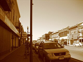
Hibbing, Minnesota City in Minnesota, United States

Hibbing is a city in Saint Louis County, Minnesota, United States. The population was 16,361 at the 2010 census. The city was built on the rich iron ore of the Mesabi Iron Range. At the edge of town is the largest open-pit iron mine in the world, the Hull–Rust–Mahoning Open Pit Iron Mine. U.S. Highway 169, State Highway 37, State Highway 73, Howard Street, and 1st Avenue are five of the main routes in Hibbing. The Range Regional Airport offers daily commercial flights between Hibbing and Minneapolis-St. Paul, as well as hosting many private pilots and the Minnesota Department of Natural Resources fire fighting aircraft.

Minnesota State Highway 37 (MN 37) is a highway in northeast Minnesota, which runs from its intersection with U.S. 169 / State Highway 73 in Hibbing and continues east to its eastern terminus at its intersection with State Highway 135 in Gilbert.

Eveleth, Minnesota City in Minnesota, United States

Eveleth is a city in Saint Louis County, Minnesota, United States. The population was 3,718 at the 2010 census.

The West Two River flows through the community. Iron Junction and Forbes are nearby.

Iron Junction, Minnesota City in Minnesota, United States

Iron Junction is a city in Saint Louis County, Minnesota, United States. The population was 86 at the 2010 census.

Forbes, Minnesota Unincorporated community in Minnesota, United States

Forbes is an unincorporated community in Saint Louis County, Minnesota, United States.

The unincorporated community of Cherry is located within Cherry Township (population 860).

Related Research Articles

Clinton Township, St. Louis County, Minnesota Township in Minnesota, United States

Clinton Township is a township in Saint Louis County, Minnesota, United States. Clinton Township was named for Clinton Markell, a prominent settler. The population was 1,015 at the 2010 census.

White Township, St. Louis County, Minnesota Township in Minnesota, United States

White Township is an urban township in Saint Louis County, Minnesota, United States. The population was 3,229 at the 2010 census.

Alborn, Minnesota Unincorporated community in Minnesota, United States

Alborn is an unincorporated community in Alborn Township, Saint Louis County, Minnesota, United States.

Twig, Minnesota Unincorporated community in Minnesota, United States

Twig is an unincorporated community in Grand Lake Township, Saint Louis County, Minnesota, United States.

Saginaw, Minnesota Unincorporated area in Minnesota, United States

Saginaw is an unincorporated area in Saint Louis County, Minnesota, United States. Although unincorporated, Saginaw has a post office with the ZIP code 55779.

Cotton, Minnesota Unincorporated community in Minnesota, United States

Cotton is an unincorporated community in Cotton Township, Saint Louis County, Minnesota, United States.

Canyon, Minnesota Unincorporated community in Minnesota, United States

Canyon is an unincorporated community in Northland Township, Saint Louis County, Minnesota, United States.

Independence, St. Louis County, Minnesota Unincorporated community in Minnesota, United States

Independence is an unincorporated community in New Independence Township, Saint Louis County, Minnesota, United States.

Culver, Minnesota Unincorporated community in Minnesota, United States

Culver is an unincorporated community in Saint Louis County, Minnesota, United States.

Sherman Corner, Minnesota Unincorporated community in Minnesota, United States

Sherman Corner is an unincorporated community in Angora Township, Saint Louis County, Minnesota, United States.

Munger, Minnesota Unincorporated community in Minnesota, United States

Munger is an unincorporated community in Solway Township, Saint Louis County, Minnesota, United States.

Palmers, Minnesota Unincorporated community in Minnesota, United States

Palmers is an unincorporated community in Duluth Township, Saint Louis County, Minnesota, United States; located on the North Shore of Lake Superior.

Burntside, Minnesota Unincorporated community in Minnesota, United States

Burntside is an unincorporated community in Morse Township, Saint Louis County, Minnesota, United States.

Sturgeon, Minnesota Unincorporated community in Minnesota, United States

Sturgeon is an unincorporated community in Sturgeon Township, Saint Louis County, Minnesota, United States.

Four Corners, Minnesota Unincorporated community in Minnesota, United States

Four Corners is an unincorporated community in Saint Louis County, Minnesota, United States; located 10 miles northwest of the city of Duluth at the junction of U.S. Highway 53 and Saint Louis County Road 13.

Peyla, Minnesota Unincorporated community in Minnesota, United States

Peyla is an unincorporated community in Vermilion Lake Township, Saint Louis County, Minnesota, United States.

Prosit, Minnesota Unincorporated community in Minnesota, United States

Prosit is an unincorporated community in Alborn Township, Saint Louis County, Minnesota, United States.

Goodland, Minnesota Unincorporated community in Minnesota, United States

Goodland is an unincorporated community in Goodland Township, Itasca County, Minnesota, United States.

References

  1. "Cherry, Minnesota". Geographic Names Information System . United States Geological Survey.