Leetonia, Hibbing, Minnesota

Last updated

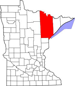
Leetonia is a neighborhood of the city of Hibbing in St. Louis County, Minnesota, United States. [1] Previously, Leetonia was its own unincorporated community before it was annexed by the city of Hibbing. County Road 63 serves as a main arterial route in the community.

In the early 1900s, the community consisted mainly of immigrant mine workers associated with the Leetonia Mine.

Historical population
CensusPop.Note
1940 396
U.S. Decennial Census [2]

Related Research Articles

<span class="mw-page-title-main">St. Louis County, Minnesota</span> County in Minnesota, United States

St. Louis County is a county located in the Arrowhead Region of the U.S. state of Minnesota. As of the 2020 census, the population was 200,231. Its county seat is Duluth. It is the largest county in Minnesota by land area, and the largest in the United States by total area east of the Mississippi River, ahead of Aroostook County, Maine.

<span class="mw-page-title-main">Harmony, Minnesota</span> City in Minnesota, United States

Harmony is a city in Fillmore County, Minnesota, United States. The population was 1,020 at the 2010 census. The town bills itself as the "Biggest Little Town in Southern Minnesota" and features the largest Amish community in the state.

<span class="mw-page-title-main">Taconite, Minnesota</span> City in Minnesota, United States

Taconite is a city in Itasca County, Minnesota, United States. The population was 360 at the 2010 census.

<span class="mw-page-title-main">Biwabik, Minnesota</span> City in Minnesota, United States

Biwabik is a city in Saint Louis County, Minnesota, United States. The population was 961 at the 2020 census.

<span class="mw-page-title-main">Floodwood, Minnesota</span> City in Minnesota, United States

Floodwood is a city in Saint Louis County, Minnesota, United States. The population was 528 at the 2010 census.

<span class="mw-page-title-main">Hibbing, Minnesota</span> City in Minnesota, United States

Hibbing is a city in Saint Louis County, Minnesota, United States. The population was 16,214 at the 2020 census. The city was built on mining the rich iron ore of the Mesabi Iron Range and still relies on that industrial activity today. At the edge of town is the world's largest open-pit iron mine, the Hull–Rust–Mahoning Open Pit Iron Mine. It is the hometown of famous singer Bob Dylan and former Governor of Minnesota Rudy Perpich.

<span class="mw-page-title-main">Virginia, Minnesota</span> City in Minnesota, United States

Virginia is a city in St. Louis County, Minnesota, United States, on the Mesabi Iron Range. With an economy heavily reliant on large-scale iron ore mining, Virginia is considered the Mesabi Range's commercial center. The population was 8,423 at the 2020 census. Virginia is just south of the Superior National Forest and about 100 miles (160 km) south of the Canada–United States border at International Falls, Minnesota, and 55 miles (89 km) northwest of Duluth, Minnesota. Virginia is a part of the Duluth metropolitan area and U.S. Highway 53 runs through town.

<span class="mw-page-title-main">Leetonia, Ohio</span> Village in Ohio, United States

Leetonia is a village in northern Columbiana County, Ohio, United States. The population was 1,833 at the 2020 census. It is part of the Salem micropolitan area, about 16 miles (26 km) south of Youngstown.

<span class="mw-page-title-main">Pine Island, Minnesota</span> City in Minnesota, United States

Pine Island is a city in Goodhue and Olmsted counties in the U.S. state of Minnesota. Most of Pine Island is in Goodhue County, but a small part extends into Olmsted County, making that portion part of the Rochester metropolitan area. As of the 2020 census, the population was 3,769.

McCormack is an unorganized territory in Saint Louis County, Minnesota, United States, located near Hibbing and Balkan Township. The population was 237 at the 2000 census.

<span class="mw-page-title-main">Mesabi Range</span> Mining district in northeastern Minnesota

The Mesabi Iron Range is a mining district in northeastern Minnesota following an elongate trend containing large deposits of iron ore. It is the largest of four major iron ranges in the region collectively known as the Iron Range of Minnesota. First described in 1866, it is the chief iron ore mining district in the United States. The district is located largely in Itasca and Saint Louis counties. It has been extensively worked since 1892, and has seen a transition from high-grade direct shipping ores through gravity concentrates to the current industry exclusively producing iron ore (taconite) pellets. Production has been dominantly controlled by vertically integrated steelmakers since 1901, and therefore is dictated largely by US ironmaking capacity and demand.

<span class="mw-page-title-main">Iron Range</span> Iron-ore mining districts around Lake Superior in the United States and Canada

The Iron Range is collectively or individually a number of elongated iron-ore mining districts around Lake Superior in the United States and Canada. Much of the ore-bearing region lies alongside the range of granite hills formed by the Giants Range batholith. These cherty iron ore deposits are Precambrian in the Vermilion Range and middle Precambrian in the Mesabi and Cuyuna ranges, all in Minnesota. The Gogebic Range in Wisconsin and the Marquette Iron Range and Menominee Range in Michigan have similar characteristics and are of similar age. Natural ores and concentrates were produced from 1848 until the mid-1950s, when taconites and jaspers were concentrated and pelletized, and started to become the major source of iron production.

<span class="mw-page-title-main">Bois Forte Indian Reservation</span> Reservation in Minnesota, USA

Bois Forte Indian Reservation is an Indian reservation formed for the Bois Forte Band of Chippewa.

<span class="mw-page-title-main">Arrowhead Region</span>

The Arrowhead Region is located in the northeastern part of the U.S. state of Minnesota, so called because of its pointed shape. The predominantly rural region encompasses 10,635.26 square miles (27,545.2 km2) of land area and includes Carlton, Cook, Lake and Saint Louis counties. Its population at the 2000 census was 248,425 residents. The region is loosely defined, and Aitkin, Itasca, and Koochiching counties are sometimes considered as part of the region, increasing the land area to 18,221.97 square miles (47,194.7 km2) and the population to 322,073 residents. Primary industries in the region include tourism and iron mining.

<span class="mw-page-title-main">Hull–Rust–Mahoning Open Pit Iron Mine</span> United States historic place

The Hull–Rust–Mahoning Open Pit Iron Mine in Hibbing, Minnesota, United States, is the largest operating open-pit iron mine in Minnesota. The pit stretches more than three miles (5 km) long, two miles (3 km) wide, and 535 feet (163 m) deep. It was established in 1895 and was one of the world's first mechanized open-pit mines.

Kelly Lake is a neighborhood of the city of Hibbing in St. Louis County, Minnesota, United States. County Road 60 / Rainey Road / 1st Avenue serves as a main arterial route in the community. Previously, Kelly Lake was its own unincorporated community before it was annexed by the city of Hibbing. U.S. Route 169 is nearby.

Little Swan is a neighborhood of the city of Hibbing in St. Louis County, Minnesota, United States. Previously, Little Swan was its own unincorporated community before it was annexed by the city of Hibbing. Little Swan is located at the East Swan River, near County Highway 5.

The Split Rock River is a 20.4-mile-long (32.8 km) tributary of the Kettle River in eastern Minnesota, United States. It begins at the outlet of Split Rock Lake in eastern Aitkin County and flows east into Carlton County, reaching the Kettle River 4 miles (6 km) south of the city of Kettle River.

Arden is an unincorporated community in western Douglas County, Missouri, United States. Arden is located on a ridge along Missouri Route O between Missouri Route 14 to the north and the community of Red Bank to the south. The community is on a ridge of Keyger Mountain at an elevation of 1,362 ft (415 m).

The Hibbing Daily Tribune was a newspaper published from 1893 to 2020 in Hibbing, Saint Louis County, Minnesota. It was owned by the Adams Publishing Group.

References

  1. "Leetonia, Hibbing, Minnesota". Geographic Names Information System . United States Geological Survey, United States Department of the Interior.
  2. United States Census Bureau. "Census of Population and Housing". Archived from the original on May 7, 2015. Retrieved December 12, 2017.

47°25′45″N92°59′07″W / 47.42917°N 92.98528°W / 47.42917; -92.98528