Prairie Lake Township, St. Louis County, Minnesota

Last updated
Prairie Lake Township, Minnesota
USA Minnesota location map.svg
Red pog.svg
Prairie Lake Township, Minnesota
Location within the state of Minnesota
Usa edcp location map.svg
Red pog.svg
Prairie Lake Township, Minnesota
Prairie Lake Township, Minnesota (the United States)
Coordinates: 46°47′39″N92°58′34″W / 46.79417°N 92.97611°W / 46.79417; -92.97611 Coordinates: 46°47′39″N92°58′34″W / 46.79417°N 92.97611°W / 46.79417; -92.97611
Country United States
State Minnesota
County Saint Louis
Area
  Total35.7 sq mi (92.4 km2)
  Land35.4 sq mi (91.7 km2)
  Water0.3 sq mi (0.8 km2)
Elevation
1,260 ft (384 m)
Population
 (2010)
  Total50
  Density1.4/sq mi (0.54/km2)
Time zone UTC-6 (Central (CST))
  Summer (DST) UTC-5 (CDT)
FIPS code 27-52306 [1]
GNIS feature ID0665349 [2]

Prairie Lake Township is a township in Saint Louis County, Minnesota, United States. The population was 50 at the 2010 census. [3]

Contents

Balsam Road, Moen Road, and Graff Road pass through the township.

Geography

According to the United States Census Bureau, the township has a total area of 35.7 square miles (92 km2); 35.4 square miles (92 km2) is land and 0.3 square miles (0.78 km2), or 0.81%, is water.

Prairie Lake Township is located in the southwest part of Saint Louis County. State Highway 73 (MN 73) is nearby.

The Prairie River flows through the township.

The northern and west–central portions of Prairie Lake Township are located within the Savanna State Forest.

Adjacent townships, cities, and communities

The following are adjacent to Prairie Lake Township :

Demographics

At the 2000 census there were 51 people, 20 households, and 15 families living in the township. The population density was 1.4 people per square mile (0.6/km2). There were 46 housing units at an average density of 1.3/sq mi (0.5/km2). The racial makeup of the township was 100.00% White. [1] Of the 20 households 35.0% had children under the age of 18 living with them, 55.0% were married couples living together, 15.0% had a female householder with no husband present, and 25.0% were non-families. 25.0% of households were one person and 5.0% were one person aged 65 or older. The average household size was 2.55 and the average family size was 3.00.

The age distribution was 33.3% under the age of 18, 21.6% from 25 to 44, 21.6% from 45 to 64, and 23.5% 65 or older. The median age was 42 years. For every 100 females, there were 104.0 males. For every 100 females age 18 and over, there were 88.9 males.

The median household income was $36,250 and the median family income was $31,875. Males had a median income of $35,000 versus $0 for females. The per capita income for the township was $8,914. There were 31.3% of families and 32.9% of the population living below the poverty line, including 46.3% of under eighteens and none of those over 64.

Related Research Articles

Aitkin County, Minnesota U.S. county in Minnesota

Aitkin County is a county in the U.S. state of Minnesota. As of the 2010 United States Census, the population was 16,202. Its county seat is Aitkin. Part of the Mille Lacs Indian Reservation is in the county. The county was created in 1857 and organized in 1871.

Aitkin Township, Aitkin County, Minnesota Township in Minnesota, United States

Aitkin Township is a township in Aitkin County, Minnesota, United States. The population was 856 as of the 2010 census.

Balsam Township, Aitkin County, Minnesota Township in Minnesota, United States

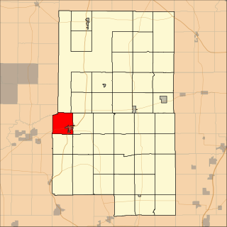
Balsam Township is a township in Aitkin County, Minnesota, United States. The population was 42 as of the 2010 census.

Clark Township, Aitkin County, Minnesota Township in Minnesota, United States

Clark Township is a township in Aitkin County, Minnesota, United States. The population was 169 as of the 2010 census.

Cornish Township, Aitkin County, Minnesota Township in Minnesota, United States

Cornish Township is a township in Aitkin County, Minnesota, United States. The population was 28 as of the 2010 census.

Haugen Township, Aitkin County, Minnesota Township in Minnesota, United States

Haugen Township is a township in Aitkin County, Minnesota, United States. The population was 178 at the 2010 census.

Millward Township, Aitkin County, Minnesota Township in Minnesota, United States

Millward Township is a township in Aitkin County, Minnesota, United States. The population was 72 as of the 2010 census.

Salo Township, Aitkin County, Minnesota Township in Minnesota, United States

Salo Township is a township in Aitkin County, Minnesota, United States. The population was 102 as of the 2010 census.

Shamrock Township, Aitkin County, Minnesota Township in Minnesota, United States

Shamrock Township is a township in Aitkin County, Minnesota, United States. The population was 1,272 as of the 2010 census.

Turner Township, Aitkin County, Minnesota Township in Minnesota, United States

Turner Township is a township in Aitkin County, Minnesota, United States. The population was 208 as of the 2010 census.

Beseman Township, Carlton County, Minnesota Township in Minnesota, United States

Beseman Township is a township in Carlton County, Minnesota, United States; located near Wright and Cromwell. The population was 149 as of the 2000 census. Beseman Township was named for Ernst Besemann, a local landowner.

Split Rock Township, Carlton County, Minnesota Township in Minnesota, United States

Split Rock Township is a township in Carlton County, Minnesota, United States. The population was 124 at the 2000 census. Split Rock Township took its name from the Split Rock River.

Arrowhead Township, St. Louis County, Minnesota Township in Minnesota, United States

Arrowhead Township is a township in Saint Louis County, Minnesota, United States. The population was 223 at the 2010 census.

Cedar Valley Township, St. Louis County, Minnesota Township in Minnesota, United States

Cedar Valley Township is a township in Saint Louis County, Minnesota, United States. Cedar Valley Township was named for the white cedar in the valley of the Floodwood River. The population was 195 at the 2010 census.

Elmer Township, St. Louis County, Minnesota Township in Minnesota, United States

Elmer Township is a township in Saint Louis County, Minnesota, United States. The population was 151 at the 2010 census.

Fine Lakes Township, St. Louis County, Minnesota Township in Minnesota, United States

Fine Lakes Township is a township in Saint Louis County, Minnesota, United States. The population was 134 at the 2010 census.

Floodwood Township, St. Louis County, Minnesota Township in Minnesota, United States

Floodwood Township is a township in Saint Louis County, Minnesota, United States. The population was 280 at the 2010 census. The township took its name from the Floodwood River.

Halden Township, St. Louis County, Minnesota Township in Minnesota, United States

Halden Township is a township in Saint Louis County, Minnesota, United States. The population was 129 at the 2010 census.

Van Buren Township, St. Louis County, Minnesota Township in Minnesota, United States

Van Buren Township is a township in Saint Louis County, Minnesota, United States. It was named for Martin Van Buren, the eighth President of the United States. The population was 189 at the 2010 census.

Potshot Lake is an unorganized territory in Saint Louis County, Minnesota, United States, located near Floodwood. The population was 73 at the 2000 census.

References

  1. 1 2 "U.S. Census website". United States Census Bureau . Retrieved 2008-01-31.
  2. "US Board on Geographic Names". United States Geological Survey. 2007-10-25. Retrieved 2008-01-31.
  3. "Race, Hispanic or Latino, Age, and Housing Occupancy: 2010 Census Redistricting Data (Public Law 94-171) Summary File (QT-PL), Prairie Lake township, St. Louis County, Minnesota". United States Census Bureau . Retrieved October 26, 2011.