Ash Lake, Minnesota

Last updated

Ash Lake
USA Minnesota location map.svg
Red pog.svg
Ash Lake
Location of the community of Ash Lake
within Saint Louis County
Usa edcp location map.svg
Red pog.svg
Ash Lake
Ash Lake (the United States)
Coordinates: 48°13′08″N92°54′58″W / 48.21889°N 92.91611°W / 48.21889; -92.91611
Country United States
State Minnesota
County Saint Louis
Unorganized territory Northwest St. Louis
Elevation
1,335 ft (407 m)
Population
  Total20
Time zone UTC-6 (Central (CST))
  Summer (DST) UTC-5 (CDT)
ZIP codes
55771
Area code 218
GNIS feature ID660687 [1]

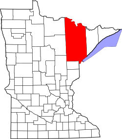
Ash Lake is an unincorporated community in Saint Louis County, Minnesota, United States; located within the Kabetogama State Forest.

The community is 13 miles (21 km) north of Orr, and 30 miles (48 km) north of Cook. It lies along U.S. Highway 53 near UT Road 8146, Jacobs Road. The Ash River and Ash Lake are both in the vicinity.

Ash Lake is 40 miles (64 km) southeast of International Falls.

Related Research Articles

<span class="mw-page-title-main">Interstate 94</span> Interstate Highway across the upper Midwestern US

Interstate 94 (I-94) is an east–west Interstate Highway connecting the Great Lakes and northern Great Plains regions of the United States. Its western terminus is just east of Billings, Montana, at a junction with I-90; its eastern terminus is in Port Huron, Michigan, where it meets with I-69 and crosses the Blue Water Bridge into Sarnia, Ontario, Canada, where the route becomes Ontario Highway 402. It thus lies along the primary overland route from Seattle to Toronto and is the only east–west Interstate Highway to have a direct connection to Canada.

<span class="mw-page-title-main">St. Louis County, Minnesota</span> County in Minnesota, United States

St. Louis County is a county located in the Arrowhead Region of the U.S. state of Minnesota. As of the 2020 census, the population was 200,231. Its county seat is Duluth. It is the largest county in Minnesota by land area, and the largest in the United States by total area east of the Mississippi River, ahead of Aroostook County, Maine.

<span class="mw-page-title-main">Lincoln County, Minnesota</span> County in Minnesota, United States

Lincoln County is a county in the U.S. state of Minnesota. As of the 2020 census, the population was 5,640. Its county seat is Ivanhoe.

Angora Township is a township in Saint Louis County, Minnesota, United States. The population was 249 at the 2010 census. Angora Township was named after Angora, in Turkey.

Grand Lake Township is a township in Saint Louis County, Minnesota, United States. The population was 2,779 at the 2010 census.

Vermilion Lake Township is a township in Saint Louis County, Minnesota, United States. The population was 278 at the 2010 census.

White Township is an urban township in Saint Louis County, Minnesota, United States. The population was 3,229 at the 2010 census.

<span class="mw-page-title-main">U.S. Route 75</span> Highway in the United States

U.S. Route 75 is a north–south U.S. Highway that runs 1,239 miles (1,994 km) in the central United States. The highway's northern terminus is located at Noyes, Minnesota, which connects to the Canadian border, where it once continued as Manitoba Highway 75 on the other side of the now-closed border crossing. Its southern terminus is located at Interstate 30 (I-30) and I-45 in Dallas, Texas, where it is known as North Central Expressway.

<span class="mw-page-title-main">U.S. Route 2</span> U.S. Numbered Highway

U.S. Route 2 or U.S. Highway 2 (US 2) is an east–west United States Numbered Highway spanning 2,571 miles (4,138 km) across the northern continental United States. US 2 consists of two segments connected by various roadways in southern Canada. Unlike some routes, which are disconnected into segments because of encroaching Interstate Highways, the two portions of US 2 were designed to be separate in the original 1926 highway plan.

<span class="mw-page-title-main">U.S. Route 8</span> U.S. Highway in Minnesota, Wisconsin, and Michigan

U.S. Highway 8 (US 8) is a United States Numbered Highway that runs primarily east–west for 280 miles (451 km), mostly within the state of Wisconsin. It connects Interstate 35 (I-35) in Forest Lake, Minnesota, to US 2 at Norway in the Upper Peninsula of Michigan near the border with Wisconsin. Except for the short freeway segment near Forest Lake, and sections near the St. Croix River bridge and Rhinelander, Wisconsin, it is mostly an undivided surface road. As a state highway in the three states, US 8 is maintained by the Minnesota, Wisconsin and Michigan departments of transportation.

<span class="mw-page-title-main">Minnesota State Highway 1</span>

Minnesota State Highway 1 is a state highway across northern Minnesota, United States, which runs from North Dakota Highway 54 (ND 54) at the North Dakota state line and continues east to its eastern terminus at MN 61 at the unincorporated community of Illgen City in Beaver Bay Township on the North Shore of Lake Superior. At 346 miles (557 km) in length, MN 1 is the longest state route in Minnesota.

<span class="mw-page-title-main">Embarrass, Minnesota</span> Unincorporated community in Minnesota, United States

Embarrass is an unincorporated community in Embarrass Township, Saint Louis County, Minnesota, United States.

<span class="mw-page-title-main">Big Bog State Recreation Area</span> State park in Minnesota

Big Bog State Recreation Area, a recent addition to the Minnesota state park system, is located on Minnesota State Highway 72, north of Waskish, Minnesota. It covers 9,459 acres (38.3 km2), primarily swamps, bogs, and upland "islands".

<span class="mw-page-title-main">Finland, Minnesota</span> Unincorporated community in Minnesota, US

Finland is an unincorporated community and census-designated place (CDP) in Crystal Bay and Beaver Bay townships, Lake County, Minnesota, United States. As of the 2020 census, its population was 195.

Central Lakes is an unincorporated community in Saint Louis County, Minnesota, United States.

Crane Lake is an unincorporated community in Crane Lake Township, Saint Louis County, Minnesota, United States; located within the Kabetogama State Forest.

Bear River is an unincorporated community in Itasca and Saint Louis counties in the U.S. state of Minnesota.

<span class="mw-page-title-main">U.S. Route 2 in Minnesota</span> Section of U.S. Highway in Minnesota, United States

U.S. Highway 2 (US 2) is a United States Numbered Highway in northwest and northeast Minnesota, which runs from the Red River at East Grand Forks and continues east to Duluth, where the route crosses the Richard I. Bong Memorial Bridge over the Saint Louis Bay. The route connects the cities of East Grand Forks, Bemidji, Grand Rapids, and Duluth.

Dunbar is an unincorporated community in Good Hope Township, Itasca County, Minnesota, United States. The community is located northwest of Squaw Lake at the junction of Itasca County Roads 32 and 149. State Highway 46 is nearby.

References

  1. "Ash Lake, Minnesota". Geographic Names Information System . United States Geological Survey, United States Department of the Interior.