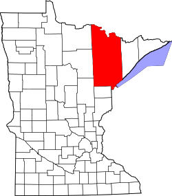
Vermilion Dam, Minnesota

Last updated

Vermilion Dam
USA Minnesota location map.svg
Red pog.svg
Vermilion Dam
Location of the community of Vermilion Dam
within Saint Louis County
Usa edcp location map.svg
Red pog.svg
Vermilion Dam
Vermilion Dam (the United States)
Coordinates: 47°57′40″N92°28′34″W / 47.96111°N 92.47611°W / 47.96111; -92.47611
Country United States
State Minnesota
County Saint Louis
Elevation
1,358 ft (414 m)
Population
  Total20
Time zone UTC-6 (Central (CST))
  Summer (DST) UTC-5 (CDT)
ZIP code
55771
Area code 218
GNIS feature ID662712 [1]

Vermilion Dam is an unincorporated community in Saint Louis County, Minnesota, United States.

The community is located 21 miles northeast of Cook, near the junction of Saint Louis County Road 24 and County Road 422.

Vermilion Dam is located within the Kabetogama State Forest.

Related Research Articles

<span class="mw-page-title-main">St. Louis County, Minnesota</span> County in Minnesota, United States

St. Louis County is a county located in the Arrowhead Region of the U.S. state of Minnesota. As of the 2020 census, the population was 200,231. Its county seat is Duluth. It is the largest county in Minnesota by land area, and the largest in the United States by total area east of the Mississippi River, ahead of Aroostook County, Maine.

Beatty Township is a township in Saint Louis County, Minnesota, United States. Beatty Township bears the name of a family of pioneer settlers. The population was 372 at the 2010 census.

<span class="mw-page-title-main">Biwabik Township, St. Louis County, Minnesota</span> Township in Minnesota, United States

Biwabik Township is a township in Saint Louis County, Minnesota, United States. Biwabik is a name derived from the Ojibwe language meaning "iron". The population was 804 at the 2010 census.

Breitung Township is a township in Saint Louis County, Minnesota, United States. The population was 605 at the 2010 census.

Greenwood Township is a township in Saint Louis County, Minnesota, United States. The population was 939 at the 2010 census.

Kugler Township is a township in Saint Louis County, Minnesota, United States. The population was 175 at the 2010 census.

Owens Township is a township in Saint Louis County, Minnesota, United States. The population was 263 at the 2010 census.

Vermilion Lake Township is a township in Saint Louis County, Minnesota, United States. The population was 278 at the 2010 census.

White Township is an urban township in Saint Louis County, Minnesota, United States. The population was 3,229 at the 2010 census.

Rollins is an unincorporated community in Ault Township, Saint Louis County, Minnesota, United States.

Markham is an unincorporated community in Colvin Township, Saint Louis County, Minnesota, United States.

Shaw is an unincorporated community in Saint Louis County, Minnesota, United States; located on Saint Louis County Road 15, near Saint Louis County Road 49.

Taft is an unincorporated community in Grand Lake Township, Saint Louis County, Minnesota, United States.

<span class="mw-page-title-main">Palo, Minnesota</span> Unincorporated community in Minnesota, United States

Palo is an unincorporated community in White Township, Saint Louis County, Minnesota, United States.

Bear River is an unincorporated community in Itasca and Saint Louis counties in the U.S. state of Minnesota.

<span class="mw-page-title-main">Buyck, Minnesota</span> Unincorporated community in Minnesota, United States

Buyck is an unincorporated community in Portage Township, Saint Louis County, Minnesota, United States.

Whiteface is an unincorporated community in Cotton Township, Saint Louis County, Minnesota, United States.

Wakemup is an unincorporated community in Beatty Township, Saint Louis County, Minnesota, United States.

Peyla is an unincorporated community in Vermilion Lake Township, Saint Louis County, Minnesota, United States.

Soudan is an unincorporated community and census-designated place (CDP) in Breitung Township, Saint Louis County, Minnesota, United States. As of the 2010 census, its population was 446.

References

  1. "Vermilion Dam, Minnesota". Geographic Names Information System . United States Geological Survey, United States Department of the Interior.