Nett Lake (CDP), Minnesota

Last updated

Nett Lake
USA Minnesota location map.svg
Red pog.svg
Nett Lake
Location of the community of Nett Lake
within Nett Lake Territory, Saint Louis County
Usa edcp location map.svg
Red pog.svg
Nett Lake
Nett Lake (the United States)
Coordinates: 48°06′53″N93°04′52″W / 48.11472°N 93.08111°W / 48.11472; -93.08111
Country United States
State Minnesota
County Saint Louis
Area
[1]
  Total1.72 sq mi (4.46 km2)
  Land1.72 sq mi (4.46 km2)
  Water0.00 sq mi (0.00 km2)
Elevation
1,296 ft (395 m)
Population
 (2020)
  Total230
  Density133.64/sq mi (51.61/km2)
Time zone UTC-6 (Central (CST))
  Summer (DST) UTC-5 (CDT)
ZIP codes
55771
Area code 218
GNIS feature ID2628823 [2]

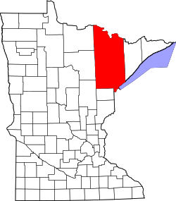
Nett Lake is an unincorporated community and census-designated place (CDP) in Nett Lake Territory, Saint Louis County, Minnesota, United States; located on the shore of Nett Lake. As of the 2010 census, its population was 284. [3]

The community of Nett Lake is located 18 miles west of Orr, and 31 miles northwest of Cook.

Saint Louis County Road 23 (CR 23) (Nett Lake Road) serves as a main route in the community.

The unincorporated community of Nett Lake is located within the Nett Lake Indian Reservation (Bois Forte Indian Reservation).

Demographics

Historical population
CensusPop.Note
2020 230
U.S. Decennial Census [4]

Related Research Articles

<span class="mw-page-title-main">Koochiching County, Minnesota</span> County in Minnesota, United States

Koochiching County is a county in the U.S. state of Minnesota. As of the 2020 census, the population was 12,062. Its county seat is International Falls. A portion of the Bois Forte Indian Reservation is in the county. A small part of Voyageurs National Park extends into its boundary, with Lake of the Woods County to its northwest.

Perch Lake Township is a township in Carlton County, Minnesota, United States. The population was 998 as of the 2000 census. "Perch Lake" is probably an English translation of the Native American name for this township's namesake lake.

Arrowhead Township is a township in Saint Louis County, Minnesota, United States. The population was 223 at the 2010 census.

Beatty Township is a township in Saint Louis County, Minnesota, United States. Beatty Township bears the name of a family of pioneer settlers. The population was 372 at the 2010 census.

Brevator Township is a township in Saint Louis County, Minnesota, United States. The population was 1,269 at the 2010 census.

Fairbanks Township is a township in Saint Louis County, Minnesota, United States. The population was 63 at the 2010 census.

Grand Lake Township is a township in Saint Louis County, Minnesota, United States. The population was 2,779 at the 2010 census.

Greenwood Township is a township in Saint Louis County, Minnesota, United States. The population was 939 at the 2010 census.

Leiding Township is a township in Saint Louis County, Minnesota, United States. The population was 400 at the 2010 census.

Owens Township is a township in Saint Louis County, Minnesota, United States. The population was 263 at the 2010 census.

Vermilion Lake Township is a township in Saint Louis County, Minnesota, United States. The population was 278 at the 2010 census.

White Township is an urban township in Saint Louis County, Minnesota, United States. The population was 3,229 at the 2010 census.

Willow Valley Township is a township in Saint Louis County, Minnesota, United States. The population was 126 at the 2010 census.

Kabetogama Township is a township in Saint Louis County, Minnesota, United States. The population was 135 at the 2010 census. A portion of the township is located within the Kabetogama State Forest.

<span class="mw-page-title-main">Bois Forte Indian Reservation</span> Reservation in Minnesota, USA

Bois Forte Indian Reservation is an Indian reservation formed for the Bois Forte Band of Chippewa.

<span class="mw-page-title-main">Grand Portage Indian Reservation</span>

The Grand Portage Indian Reservation is the Indian reservation of the Grand Portage Band of Minnesota Chippewa Tribe, a federally recognized tribe in Minnesota.

Inger is an unincorporated community and census-designated place (CDP) in Itasca County, Minnesota, United States, along the Bowstring River of the Leech Lake Indian Reservation. As of the 2010 census, its population was 212.

Greaney is an unincorporated community in Saint Louis County, Minnesota, United States. Greaney is located within ZIP code 55771, based in Orr.

Goodland is an unincorporated community in Goodland Township, Itasca County, Minnesota, United States.

Ball Club is an unincorporated community and census-designated place (CDP) in Itasca County, Minnesota, United States; located within the Leech Lake Indian Reservation. As of the 2010 census, its population was 342. Ball Club is located between Zemple and Bena.

References

  1. "2020 U.S. Gazetteer Files". United States Census Bureau. Retrieved July 24, 2022.
  2. "Nett Lake, Minnesota". Geographic Names Information System . United States Geological Survey, United States Department of the Interior.
  3. "U.S. Census website". United States Census Bureau . Retrieved May 14, 2011.
  4. "Census of Population and Housing". Census.gov. Retrieved June 4, 2016.