Celina, Minnesota

Last updated

Celina
USA Minnesota location map.svg
Red pog.svg
Celina
Location of the community of Celina
within Saint Louis County
Usa edcp location map.svg
Red pog.svg
Celina
Celina (the United States)
Coordinates: 47°51′57″N93°03′43″W / 47.86583°N 93.06194°W / 47.86583; -93.06194
Country United States
State Minnesota
County Saint Louis
Elevation
1,319 ft (402 m)
Population
  Total10
Time zone UTC-6 (Central (CST))
  Summer (DST) UTC-5 (CDT)
ZIP code
55723
Area code 218
GNIS feature ID660973 [1]

Celina was an unincorporated community in Saint Louis County, Minnesota, United States. The early 20th century community was once home to a Lutheran church, post office, and general stores. The village was located near Greaney and Bear River, Minnesota.

Contents

Geography

The community was located 18 miles west of Cook at the junction of State Highway 1 (MN 1) and Saint Louis County Highway 5 (CR 5). The boundary line between Saint Louis, Itasca, and Koochiching counties is near Celina.

Celina was 112 miles from the county seat of Duluth, Minnesota. [2] The communities of Greaney, Bear River, and Togo are nearby.

Climate

Climate data for Celina 2E, Minnesota, 1991–2020 normals, 2011-2020 precip/snowfall: 1285ft (392m)
MonthJanFebMarAprMayJunJulAugSepOctNovDecYear
Record high °F (°C)45
(7)
59
(15)
76
(24)
80
(27)
91
(33)
90
(32)
94
(34)
91
(33)
87
(31)
87
(31)
69
(21)
45
(7)
94
(34)
Mean maximum °F (°C)37.1
(2.8)
42.4
(5.8)
57.0
(13.9)
68.7
(20.4)
83.1
(28.4)
84.9
(29.4)
89.0
(31.7)
86.5
(30.3)
82.0
(27.8)
73.9
(23.3)
53.5
(11.9)
40.5
(4.7)
88.3
(31.3)
Mean daily maximum °F (°C)16.8
(−8.4)
22.3
(−5.4)
35.7
(2.1)
50.1
(10.1)
64.3
(17.9)
72.2
(22.3)
76.8
(24.9)
75.4
(24.1)
66.0
(18.9)
51.2
(10.7)
34.6
(1.4)
21.8
(−5.7)
48.9
(9.4)
Daily mean °F (°C)5.0
(−15.0)
8.8
(−12.9)
23.4
(−4.8)
37.4
(3.0)
50.6
(10.3)
59.6
(15.3)
64.0
(17.8)
62.2
(16.8)
53.9
(12.2)
40.9
(4.9)
26.1
(−3.3)
12.2
(−11.0)
37.0
(2.8)
Mean daily minimum °F (°C)−6.7
(−21.5)
−4.6
(−20.3)
11.1
(−11.6)
24.6
(−4.1)
36.8
(2.7)
47.0
(8.3)
51.1
(10.6)
48.9
(9.4)
41.7
(5.4)
30.6
(−0.8)
17.5
(−8.1)
2.6
(−16.3)
25.1
(−3.9)
Mean minimum °F (°C)−37.4
(−38.6)
−32.7
(−35.9)
−22.0
(−30.0)
5.0
(−15.0)
22.1
(−5.5)
28.7
(−1.8)
38.5
(3.6)
34.3
(1.3)
24.5
(−4.2)
15.9
(−8.9)
−8.2
(−22.3)
−25.9
(−32.2)
−37.9
(−38.8)
Record low °F (°C)−47
(−44)
−47
(−44)
−38
(−39)
−7
(−22)
17
(−8)
24
(−4)
34
(1)
31
(−1)
19
(−7)
10
(−12)
−17
(−27)
−39
(−39)
−47
(−44)
Average precipitation inches (mm)0.97
(25)
0.86
(22)
1.05
(27)
2.12
(54)
3.09
(78)
4.61
(117)
4.20
(107)
3.53
(90)
3.19
(81)
2.50
(64)
1.42
(36)
1.30
(33)
28.84
(734)
Average snowfall inches (cm)13.1
(33)
13.1
(33)
6.7
(17)
8.7
(22)
trace0.0
(0.0)
0.0
(0.0)
0.0
(0.0)
trace2.0
(5.1)
7.6
(19)
13.0
(33)
64.2
(162.1)
Source 1: NOAA [3]
Source 2: XMACIS (precip/snowfall, records & monthly max/mins) [4]

History

1920 map of west central St Louis County, Minnesota, showing the locations of Celina, Greaney, Hughes, and other communities. 1920 map Minnesota - west central St Louis County.png
1920 map of west central St Louis County, Minnesota, showing the locations of Celina, Greaney, Hughes, and other communities.

Celina was a St. Louis County village in the early 20th century. A post office operated in Celina from 1908 to 1913. The postmaster was Theodore Hall. In 1913, the post office closed; mail was routed through Nass. The post office reopened in 1914 and closed again in 1935. [5] John Gilbertson also served as a postmaster in Celina. [6]

The Evangelical Lutheran Church operated in Celina around this time; [7] the Celina Lutheran Church was founded in 1909. [8] [9] An area resident wrote, "There is room here for many more of our Norwegian Lutheran people. The country about Cook, Bear River, Celina, Sturgeon River, and several places here, is very good and yet cheap. St. Louis County is known for the good roads that are built, and the mining companies have to pay most of the cost. There are good schools here, the "range towns" are known all over the country for their splendid school buildings and their good system of governance. [...] In Celina, we plan to build a church in the spring, if everything goes according to what we have planned." [10]

There were also two general stores in Celina, one operated by Theodore Hall. [11] [12]

A lookout tower was to be constructed in the Celina area in 1929 to protect the area from fires. [13]

In 1940, Celina's population was 5. [2]

In 1974, the County Highway 114 bridge on the Little Fork River between the communities of Greaney and Celina was heavily damaged by fire. The cost to repair the bridge was estimated at $750,000. The bridge, which was 200 feet (61 m) long, was the main link between the two settlements. [14]

In 2006, Celina had an estimated population of 10. [15]

Related Research Articles

<span class="mw-page-title-main">Duluth, Minnesota</span> City in Minnesota, USA

Duluth is a port city in the U.S. state of Minnesota and the county seat of St. Louis County. Located on Lake Superior in Minnesota's Arrowhead Region, the city is a hub for cargo shipping. Commodities shipped from the Port of Duluth include coal, iron ore, grain, limestone, cement, salt, wood pulp, steel coil, and wind turbine components. Duluth is south of the Iron Range and the Boundary Waters Canoe Area Wilderness.

<span class="mw-page-title-main">St. Louis County, Minnesota</span> County in Minnesota, United States

St. Louis County is a county located in the Arrowhead Region of the U.S. state of Minnesota. As of the 2020 census, the population was 200,231. Its county seat is Duluth. It is the largest county in Minnesota by land area, and the largest in the United States by total area east of the Mississippi River. St. Louis County is included in the Duluth, MN–Superior, WI Metropolitan Statistical Area.

<span class="mw-page-title-main">Hennepin County, Minnesota</span> County in Minnesota, United States

Hennepin County is a county in the U.S. state of Minnesota. Its county seat is Minneapolis, the state's most populous city. The county is named in honor of the 17th-century explorer Father Louis Hennepin. The county extends from Minneapolis to the suburbs and outlying cities in the western part of the county. The county's natural areas are covered with extensive woods, hills, and lakes.

<span class="mw-page-title-main">Chisago County, Minnesota</span> County in Minnesota, United States

Chisago County is a county in the east-central part of the U.S. state of Minnesota. The county covers an area of 442 square miles and, as of the 2020 Census, had a population of 56,621 people. It is part of the Minneapolis-St. Paul-Bloomington Metropolitan Statistical Area.

<span class="mw-page-title-main">Grand Rapids, Minnesota</span> City in Minnesota, United States

Grand Rapids is a city in Itasca County, Minnesota, United States, and it is the county seat. The population was 11,126 at the 2020 census. The city is named for the 3.5-mile (5.6 km) long rapids in the Mississippi River which was the uppermost limit of practical steamboat travel during the late 19th century. Today the rapids are hidden below the dam of UPM Paper Company.

<span class="mw-page-title-main">Fergus Falls, Minnesota</span> City in Minnesota, United States

Fergus Falls is a city in and the county seat of Otter Tail County, Minnesota, United States. The population was 14,119 at the 2020 census.

Linden Grove Township is a township in Saint Louis County, Minnesota, United States. The population was 145 at the 2010 census.

<span class="mw-page-title-main">Duluth MN–WI Metropolitan Area</span> Place in Minnesota and Wisconsin, United States

The Duluth MN–WI Metropolitan Area, commonly called the Twin Ports, is a small metropolitan area centered around the cities of Duluth, Minnesota and Superior, Wisconsin. The Twin Ports are located at the western part of Lake Superior and together are considered one of the larger cargo ports in the United States. The Twin Ports are close to many natural attractions such as the North Shore, the Apostle Islands, and the Superior National Forest.

<span class="mw-page-title-main">U.S. Route 53</span> U.S. Highway in Minnesota and Wisconsin

U.S. Route 53, or U.S. Highway 53 (U.S. 53), is a north–south U.S. highway that runs for 404 miles (650 km) from La Crosse, Wisconsin to International Falls, Minnesota. It is the primary north–south route in northwestern Wisconsin, serving as a vital link between I-94 at Eau Claire, Wisconsin and the Twin Ports of Superior, Wisconsin, and Duluth, Minnesota. The entire route from Eau Claire to the city limits of Superior is a four lane divided highway. The highway's northern terminus is at the Fort Frances–International Falls International Bridge in International Falls, Minnesota, at the Canada–US border. Its southern terminus is in La Crosse, Wisconsin, at U.S. Highway 14.

<span class="mw-page-title-main">Minnesota State Highway 61</span> Highway in Minnesota

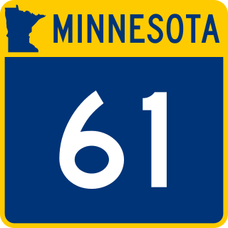
Minnesota State Highway 61 is a 150.321-mile-long (241.918 km) highway in northeast Minnesota, which runs from a junction with Interstate 35 (I-35) in Duluth at 26th Avenue East, and continues northeast to its northern terminus at the Canadian border near Grand Portage, connecting to Ontario Highway 61 at the Pigeon River Bridge. The route is a scenic highway, following the North Shore of Lake Superior, and is part of the Lake Superior Circle Tour designation that runs through Minnesota, Ontario, Michigan, and Wisconsin.

<span class="mw-page-title-main">Minnesota State Highway 23</span>

Minnesota State Highway 23 (MN 23) is a state highway that stretches from southwestern to northeastern Minnesota. At 343.723 miles (553.169 km) in length, it is the second longest state route in Minnesota, after MN 1.

<span class="mw-page-title-main">Minnesota State Highway 210</span>

Minnesota State Highway 210 (MN 210) is a state highway in west-central, central, and northeast Minnesota, which runs from North Dakota Highway 210 (ND 210) at the North Dakota state line, and continues east to its eastern terminus at its intersection with MN 23 in Duluth near the Saint Louis River.

<span class="mw-page-title-main">Minnesota State Highway 39</span> Highway in Minnesota

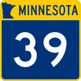
Minnesota State Highway 39 (MN 39) is a short 1.080-mile-long (1.738 km) highway in northeast Minnesota, which runs from its intersection with State Highway 23 in Duluth and continues east to its eastern terminus at the Wisconsin state line, where it becomes Wisconsin Highway 105 upon entering the village of Oliver, Wisconsin.

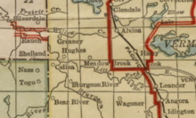
Greaney is an unincorporated community in Saint Louis County, Minnesota, United States. Greaney is located within ZIP code 55771, based in Orr.

Bengal was an unincorporated community on the boundary of Itasca County and Saint Louis County, Minnesota, United States, located about three hours north of Minneapolis. Bengal was also previously known as Powers.

Bear River is an unincorporated community in Itasca and Saint Louis counties in the U.S. state of Minnesota.

<span class="mw-page-title-main">Norwegian-American Lutheranism</span> Lutheran church tradition

The Norwegian Lutheran Church in the United States is a general term to describe the Lutheran church tradition developed within the United States by immigrants from Norway.

<span class="mw-page-title-main">U.S. Route 2 in Minnesota</span> Section of U.S. Highway in Minnesota, United States

U.S. Highway 2 (US 2) is a United States Numbered Highway in northwest and northeast Minnesota, which runs from the Red River at East Grand Forks and continues east to Duluth, where the route crosses the Richard I. Bong Memorial Bridge over the Saint Louis Bay. The route connects the cities of East Grand Forks, Bemidji, Grand Rapids, and Duluth.

John Nathan Kildahl was an American Lutheran church minister, author and educator.

Rauch is an unincorporated community in Koochiching County, Minnesota, United States.

References

  1. "Celina, Minnesota". Geographic Names Information System . United States Geological Survey, United States Department of the Interior.
  2. 1 2 The Attorneys List. United States Fidelity and Guaranty Company, Attorney List Department. 1940. p. 487. Archived from the original on November 3, 2022. Retrieved December 17, 2023.
  3. "Celina 2E, Minnesota 1991-2020 Monthly Normals". Archived from the original on December 22, 2023. Retrieved December 22, 2023.
  4. "xmACIS". National Oceanic and Atmospheric Administration. Archived from the original on August 15, 2019. Retrieved December 22, 2023.
  5. Upham, Warren (2001). Minnesota Place Names: A Geographical Encyclopedia. Minnesota Historical Society Press. p. 516. ISBN   978-0-87351-396-8 . Retrieved December 17, 2023.
  6. "Postmaster at Celina". The Duluth Herald. Duluth, MN. June 8, 1911.
  7. Church, Evangelical Lutheran (1920). Annual Report [1918]. Augsburg Publishing House. Retrieved December 17, 2023.
  8. Survey (Minn.), Historical Records (1942). Guide to Church Vital Statistics Records in Minnesota, Baptisms, Marriages, Funerals. The Survey. Retrieved December 17, 2023.
  9. Johnson, Ole S. (1925). Utvandringshistorie fra Ringerikesbygderne (in Norwegian). Decorah, Iowa: Folkebladet Publishing Companys trykkeri.
  10. Lutheraneren (in Norwegian). Augsburg Publishing House. 1922. p. 169. Landet omkring Cook, Bear River, Celina, Sturgeon River, og flere steder her, er meget godt og endnu billig. St. Louis Co. er bekjendt for de gode veier som anlægges, og minekompaniene maa betale det meste op tatten. Her er gode skoler, "rangebyene" er jo bekjendt hele landet over for sine prægtige skolehus og sit gode stelesystem. [...] Celina har vi tænkt at bygge kirke til vaaren, hvis alt gaar efter hvad vi har planet.
  11. Minnesota State Gazetteer and Business Directory. R. L. Polk and Company. 1920. Retrieved December 17, 2023.
  12. Norlie, Olaf Morgan (1918). Norske lutherske menigheter i Amerika, 1843-1916 (in Norwegian). Minneapolis, MN: Augsburg Publishing House. p. 672.
  13. "Hibbing Forest Fires Show Increase -- Series Fires Lowered on List". St. Cloud Times. St. Cloud, MN. p. 9. Retrieved December 18, 2023.
  14. "Bridge damage put at $750,000". Minneapolis Star. Minneapolis, MN. October 10, 1974. p. 59. Archived from the original on December 22, 2023. Retrieved December 17, 2023. The 200-foot bridge, which spans the Little Fork River on County Highway 114, was a main link between the communities of Celina and Greaney.
  15. "General Highway Map - St. Louis County, Minnesota" (PDF). Minnesota Department of Transportation. Archived (PDF) from the original on December 17, 2023. Retrieved December 17, 2023.

See also