Mahnomen, St. Louis County, Minnesota

Last updated
Mahnomen
USA Minnesota location map.svg
Red pog.svg
Mahnomen
Location of the community of Mahnomen
within Brevator Township, Saint Louis County
Coordinates: 46°46′23″N92°32′30″W / 46.77306°N 92.54167°W / 46.77306; -92.54167 Coordinates: 46°46′23″N92°32′30″W / 46.77306°N 92.54167°W / 46.77306; -92.54167
Country United States
State Minnesota
County Saint Louis
Township Brevator Township
Area
[1]
  Total1.27 sq mi (3.29 km2)
  Land1.27 sq mi (3.29 km2)
  Water0.00 sq mi (0.00 km2)
Elevation
1,283 ft (391 m)
Population
 (2020)
  Total231
  Density181.89/sq mi (70.20/km2)
Time zone UTC-6 (Central (CST))
  Summer (DST) UTC-5 (CDT)
Area code 218
FIPS code 27-39394
GNIS feature ID2583777 [2]

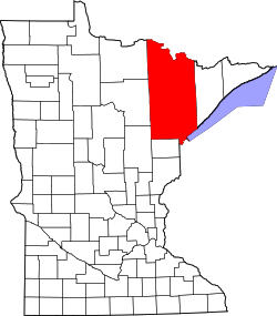
Mahnomen is an unincorporated community and census-designated place (CDP) in Brevator Township, Saint Louis County, Minnesota, United States. Its population was 239 as of the 2010 census. [3]

Mahnomen is located in the southern portion of Brevator Township near Cloquet. The community is located between Brookston and Cloquet. The Saint Louis River flows through the community.

The center of Mahnomen is generally considered at the intersection of Mahnomen Road and Brookston Road.

Demographics

Historical population
CensusPop.
2020 231
U.S. Decennial Census [4]

Related Research Articles

Perch Lake Township is a township in Carlton County, Minnesota, United States. The population was 998 as of the 2000 census. "Perch Lake" is probably an English translation of the Native American name for this township's namesake lake.

Thomson Township is a township in Carlton County, Minnesota, United States. The population was 5,003 as of the 2010 census. Thomson Township took its name from the city of Thomson.

Arrowhead Township is a township in Saint Louis County, Minnesota, United States. The population was 223 at the 2010 census.

Ault Township is a township in Saint Louis County, Minnesota, United States. The population was 109 at the 2010 census.

Brevator Township is a township in Saint Louis County, Minnesota, United States. The population was 1,269 at the 2010 census.

<span class="mw-page-title-main">Brookston, Minnesota</span> City in Minnesota, United States

Brookston is a city in Saint Louis County, Minnesota, United States; located along the Saint Louis River, opposite the mouth of the Artichoke River. The population was 118 at the 2020 census.

Cotton Township is a township in Saint Louis County, Minnesota, United States. The population was 445 at the 2010 census.

Culver Township is a township in Saint Louis County, Minnesota, United States. The population was 294 at the 2010 census.

Fairbanks Township is a township in Saint Louis County, Minnesota, United States. The population was 63 at the 2010 census.

Grand Lake Township is a township in Saint Louis County, Minnesota, United States. The population was 2,779 at the 2010 census.

Industrial Township is a township in Saint Louis County, Minnesota, United States. The population was 800 at the 2010 census.

New Independence Township is a township in Saint Louis County, Minnesota, United States. The population was 299 at the 2010 census.

Northland Township is a township in Saint Louis County, Minnesota, United States. The population was 169 at the 2010 census.

Solway Township is a township in Saint Louis County, Minnesota, United States. The population was 1,944 at the 2010 census. Solway Township was named after Solway Firth.

Stoney Brook Township is a township in Saint Louis County, Minnesota, United States. The population was 332 at the 2010 census.

<span class="mw-page-title-main">Fond du Lac Indian Reservation</span> Indian reservation in northern Minnesota

The Fond du Lac Indian Reservation is an Indian reservation in northern Minnesota near Cloquet in Carlton and Saint Louis counties. Off-reservation holdings are located across the state in Douglas County, in the northwest corner of Wisconsin. The total land area of these tribal lands is 154.49 square miles (400.1 km2). It is the land-base for the Fond du Lac Band of Lake Superior Chippewa. Before the establishment of this reservation, the Fond du Lac Band of Lake Superior Chippewa were located at the head of Lake Superior, closer to the mouth of the Saint Louis River, where Duluth has developed.

<span class="mw-page-title-main">Esko, Minnesota</span> Census-designated place in Minnesota, US

Esko is an unincorporated community and census-designated place (CDP) in Thomson Township, Carlton County, Minnesota, United States. As of the 2010 census, its population was 1,869.

Burnett is an unincorporated community in Industrial Township, Saint Louis County, Minnesota, United States.

Mahtowa is an unincorporated community and census-designated place (CDP) in Mahtowa Township, Carlton County, Minnesota, United States. As of the 2010 census, its population was 370.

Big Lake is an unincorporated community and census-designated place (CDP) in Perch Lake Township, Carlton County, Minnesota, United States. Its population was 443 as of the 2010 census.

References

  1. "2020 U.S. Gazetteer Files". United States Census Bureau. Retrieved July 24, 2022.
  2. "Mahnomen Census Designated Place". Geographic Names Information System . United States Geological Survey, United States Department of the Interior.
  3. "U.S. Census website". United States Census Bureau . Retrieved 2011-05-14.
  4. "Census of Population and Housing". Census.gov. Retrieved June 4, 2016.