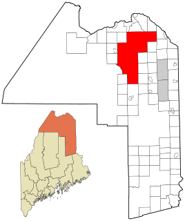
Square Lake is an unorganized territory in Aroostook County, Maine, United States. The population was 594 at the 2010 census.
East Cass is an unorganized territory in Cass County, Minnesota, United States. The population was 43 at the 2000 census. It is part of the Brainerd Micropolitan Statistical Area.
Dean Lake is an unorganized territory in Crow Wing County, Minnesota, United States. The population was 89 at the 2000 census. It is part of the Brainerd Micropolitan Statistical Area. This territory took its name from Dean Lake.
Deer Lake is an unorganized territory in Itasca County, Minnesota, United States. The population was 3,495 at the 2010 census.
Little Sand Lake is an unorganized territory in Itasca County, Minnesota, United States. As of the 2010 census, the unorganized territory population was 349.
Northeast Itasca is an unorganized territory in Itasca County, Minnesota, United States. The population was 1,179 at the 2010 census.
Lake No. 2 is an unorganized territory in Lake County, Minnesota, United States. The population was 1,955 at the 2000 census.
Camp A Lake is an unorganized territory in Saint Louis County, Minnesota, United States. The population was 16 at the 2000 census.
Crab Lake is an unorganized territory in Saint Louis County, Minnesota, United States, located north of Eagles Nest Township, and west of Morse Township. The population was 11 at the 2000 census.
Gheen is an unorganized territory in Saint Louis County, Minnesota, United States. The population was 25 at the 2000 census.
Heikkala Lake is an unorganized territory in Saint Louis County, Minnesota, United States. The population was 322 at the 2000 census.
Linwood Lake is an unorganized territory in Saint Louis County, Minnesota, United States. The population was 54 at the 2000 census.
Marion Lake is an unorganized territory in Saint Louis County, Minnesota, United States. The population was 68 at the 2000 census.
McCormack is an unorganized territory in Saint Louis County, Minnesota, United States, located near Hibbing and Balkan Township. The population was 237 at the 2000 census.
Mud Hen Lake is an unorganized territory in Saint Louis County, Minnesota, United States. The population was 320 at the 2000 census.
Sand Lake is an unorganized territory in Saint Louis County, Minnesota, United States, located within the unincorporated area of Britt. The population was 1,060 at the 2000 census.
Sturgeon River is an unorganized territory in Saint Louis County, Minnesota, United States. The population was 99 at the 2000 census.
Whiteface Reservoir is an unorganized territory in Saint Louis County, Minnesota, United States. The population was 292 at the 2000 census.
Nett Lake is an unorganized territory in Saint Louis County, Minnesota, United States. The population was 272 at the 2000 census.
Effie is an unorganized territory in Itasca County, Minnesota, United States. The population was 203 at the 2010 census.
