International Falls, Minnesota

Last updated

International Falls
Nickname(s): 
Icebox of the Nation,
Frostbite Falls
Koochiching County Minnesota Incorporated and Unincorporated areas International Falls Highlighted.svg
Location of International Falls
within Koochiching County and the U.S. state of Minnesota
Coordinates: 48°35′30″N93°24′19″W / 48.59167°N 93.40528°W / 48.59167; -93.40528 [1]
CountryUnited States
State Minnesota
County Koochiching
Founded1870
Government
   Mayor Harley M. Droba
Area
[2]
  Total6.42 sq mi (16.63 km2)
  Land6.41 sq mi (16.60 km2)
  Water0.01 sq mi (0.03 km2)
Elevation
[1]
1,131 ft (345 m)
Population
 (2020) [3]
  Total5,802
  Estimate 
(2022) [4]
5,665
  Density905.29/sq mi (349.55/km2)
Time zone UTC-6 (Central)
  Summer (DST) UTC-5 (-CDT)
ZIP code
56649, 56679
Area code 218
FIPS code 27-31040 [1]
GNIS feature ID0645435 [1]
Website ci.international-falls.mn.us
International Falls, Minnesota
International Falls, on the south bank of Rainy River, which serves as the U.S.–Canada border.

International Falls (sometimes referred to as I-Falls) is a city in and the county seat of Koochiching County, Minnesota, United States. [1] The population was 5,802 at the time of the 2020 census. [3]

Contents

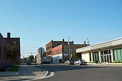
International Falls is located on the Rainy River directly across from Fort Frances, Ontario, Canada. The two cities are connected by the Fort Frances–International Falls International Bridge. Voyageurs National Park is located 11 miles east of International Falls. There is a major U.S. Customs and Border Protection Port of Entry on the International Falls side of the toll bridge and a Canadian Customs entry point on the north side of the bridge.

International Falls is nicknamed the "Icebox of the Nation,” with an average of 109.4 days per year with a high temperature below 32 °F (0 °C).

History

The area now known as International Falls was inhabited by many indigenous peoples. The International Falls area was well known to explorers, missionaries, and voyagers as early as the 17th century. It was not until April 1895 that the community was platted by L. A. Ogaard, a teacher and preacher for the Koochiching Company, and named Koochiching. The word “Koochiching” comes from either the Ojibwe word Gojijiing or the Cree Kocicīhk, both meaning “at the place of inlets,” referring to the neighboring Rainy Lake and River. The European inhabitants gave the names Rainy Lake and Rainy River to the nearby bodies of water because of the mist-like rain present at the falls where the lake flowed into the river.

On August 10, 1901, the village was incorporated and two years later its name was changed to International Falls in recognition of the river's role as a border between the United States and Canada. It was incorporated as a city in 1909. [5]

Realizing the potential for water power and mills in the area, industrialist E.W. Backus, president of the Minnesota and Ontario Paper Company in the early 20th century, built a dam on the Rainy River to power the company's mills. Purchased by Boise Cascade Corporation in 1965, and sold to an investment group in 2003, the company remains the largest business and employer in the area. In 2013 Boise laid off 394 employees and closed down a paper machine. It then sold to Packaging Corporation of America (PCA).

Geography

According to the United States Census Bureau, the city has a total area of 6.53 square miles (16.91 km2), of which 6.42 square miles (16.63 km2) is land and 0.11 square miles (0.28 km2) is water. [6]

Climate

Climate chart for International Falls Monthly Climate Normals (1991-2020) - International FallsArea, MN (ThreadEx).svg
Climate chart for International Falls

International Falls, with its relatively central position in the North American continent, has a warm-summer humid continental climate (Köppen: Dfb), with long, bitterly cold winters and humid, warm summers and is part of USDA Plant hardiness zone 3a. [7] January averages 5.0 °F (−15.0 °C), and lows reach 0 °F (−18 °C) on an average of 57.2 nights annually. [8] Highs only reach the freezing point or above an average of 16.7 days in the months of December, January, and February, and the temperature often stays below freezing for weeks at a time during the winter. In the winter of 1978 to 1979, the temperature stayed below freezing for 101 days, from November 17 to February 25. [8] Seasonal snowfall averages 73.0 in (185 cm); due to the cold typically preventing significant melting for much of the winter, snow depths of 5 in (13 cm) or more are seen on a majority of days from December through March. [9] Spring, and more especially autumn, are short but mild transition seasons. July averages 64.9 °F (18.3 °C), with highs reaching 90 °F (32 °C) an average of only 2 days annually, and in close to 40% of years, the temperature does not rise that high. Precipitation averages about 25.37 in (644 mm) per year, and is concentrated in the warmer months. The average window for freezing temperatures is September 14 through May 26, allowing a frost-free period of 110 days; however, the all-time record for the latest first freeze was set relatively recently on October 17, 2021, being over a month late. [8] Measurable snowfall (≥0.1 in or 0.25 cm) arrives on average on October 18 and departs April 22. [8] The all-time record high temperature is 103 °F (39 °C), set on July 22, 1923, while the all-time record low is −55 °F (−48 °C), set on January 6, 1909, a range of 158 °F (88 °C); the record cold maximum is −29 °F (−34 °C), set on the same day as the record low, while, conversely, the record warm minimum is 79 °F (26 °C) on July 16, 1898. [8]

Climate data for International Falls, Minnesota (Falls International Airport), 1991–2020 normals, [lower-alpha 1] extremes 1897–present
MonthJanFebMarAprMayJunJulAugSepOctNovDecYear
Record high °F (°C)49
(9)
58
(14)
79
(26)
93
(34)
95
(35)
101
(38)
103
(39)
96
(36)
96
(36)
88
(31)
74
(23)
56
(13)
103
(39)
Mean maximum °F (°C)38.5
(3.6)
42.9
(6.1)
56.1
(13.4)
72.5
(22.5)
83.7
(28.7)
86.7
(30.4)
88.7
(31.5)
87.4
(30.8)
83.6
(28.7)
74.0
(23.3)
54.7
(12.6)
39.7
(4.3)
90.7
(32.6)
Mean daily maximum °F (°C)15.7
(−9.1)
21.7
(−5.7)
35.4
(1.9)
50.1
(10.1)
64.2
(17.9)
73.5
(23.1)
77.7
(25.4)
76.0
(24.4)
66.4
(19.1)
51.2
(10.7)
34.4
(1.3)
20.8
(−6.2)
48.9
(9.4)
Daily mean °F (°C)5.0
(−15.0)
9.5
(−12.5)
23.6
(−4.7)
38.1
(3.4)
51.1
(10.6)
60.8
(16.0)
64.9
(18.3)
62.8
(17.1)
54.2
(12.3)
41.1
(5.1)
26.3
(−3.2)
11.8
(−11.2)
37.4
(3.0)
Mean daily minimum °F (°C)−5.8
(−21.0)
−2.6
(−19.2)
11.8
(−11.2)
26.1
(−3.3)
38.1
(3.4)
48.2
(9.0)
52.0
(11.1)
49.7
(9.8)
42.0
(5.6)
31.1
(−0.5)
18.1
(−7.7)
2.7
(−16.3)
26.0
(−3.3)
Mean minimum °F (°C)−33.0
(−36.1)
−28.7
(−33.7)
−16.4
(−26.9)
10.7
(−11.8)
24.4
(−4.2)
33.4
(0.8)
40.1
(4.5)
37.0
(2.8)
26.8
(−2.9)
16.9
(−8.4)
−3.2
(−19.6)
−25.2
(−31.8)
−36.2
(−37.9)
Record low °F (°C)−55
(−48)
−48
(−44)
−38
(−39)
−14
(−26)
8
(−13)
23
(−5)
32
(0)
27
(−3)
19
(−7)
2
(−17)
−32
(−36)
−41
(−41)
−55
(−48)
Average precipitation inches (mm)0.79
(20)
0.69
(18)
1.02
(26)
1.64
(42)
3.06
(78)
3.78
(96)
3.97
(101)
2.82
(72)
3.00
(76)
2.22
(56)
1.39
(35)
0.99
(25)
25.37
(644)
Average snowfall inches (cm)15.7
(40)
12.6
(32)
7.9
(20)
7.0
(18)
0.2
(0.51)
0.0
(0.0)
0.0
(0.0)
0.0
(0.0)
0.1
(0.25)
1.6
(4.1)
12.1
(31)
15.8
(40)
73.0
(185)
Average precipitation days (≥ 0.01 in)10.19.08.39.412.713.812.511.012.212.610.211.1132.9
Average snowy days (≥ 0.1 in)13.611.46.94.00.40.00.00.00.12.510.012.561.4
Average relative humidity (%)70.867.465.761.161.368.671.274.877.174.278.877.170.7
Average dew point °F (°C)−5.4
(−20.8)
−0.2
(−17.9)
12.6
(−10.8)
25.2
(−3.8)
37.6
(3.1)
49.6
(9.8)
56.1
(13.4)
54.3
(12.4)
45.3
(7.4)
33.8
(1.0)
19.2
(−7.1)
2.5
(−16.4)
27.6
(−2.5)
Source: NOAA (relative humidity 1961–1990) [8] [9] [10]

See or edit raw graph data.

Icebox of the Nation

International Falls has long promoted itself as the "Icebox of the Nation"; however, the trademark for the slogan has been challenged on several occasions by the small town of Fraser, Colorado. Officials from Fraser claimed usage since 1956, International Falls since 1948. The two towns came to an agreement in 1986, when International Falls paid Fraser $2,000 to relinquish its "official" claim. However, in 1996, International Falls inadvertently failed to renew its federal trademark, although it had kept its state trademark up to date. Fraser then filed to gain the federal trademark. [11] International Falls submitted photographic proof that its 1955 Pee Wee hockey team traveled to Boston, Massachusetts with the slogan. [12] After several years of legal battles, the United States Patent and Trademark Office officially registered the slogan with International Falls on January 29, 2008, Registration Number 3375139. [13] Only a few days after announcing its success in the trademark battle, International Falls had a daily record low temperature of −40 °F (−40 °C), beating a previous record of −37 °F (−38.3 °C) in 1967. [14]

Demographics

Historical population
CensusPop.Note
1910 1,487
1920 3,448131.9%
1930 5,03646.1%
1940 5,62611.7%
1950 6,26911.4%
1960 6,7788.1%
1970 6,439−5.0%
1980 5,611−12.9%
1990 8,32448.4%
2000 6,703−19.5%
2010 6,424−4.2%
2020 5,802−9.7%
2022 (est.)5,665 [4] −2.4%
U.S. Decennial Census [15]
2020 Census [3]

As of 2000 the median income for a household in the city was $29,908, and the median income for a family was $41,458. Males had a median income of $41,584 versus $20,053 for females. The per capita income for the city was $19,171. About 10.0% of families and 14.5% of the population were below the poverty line, including 20.5% of those under age 18 and 12.3% of those age 65 or over.

2010 census

As of the census of 2010, there were 6,424 people, 2,903 households, and 1,645 families residing in the city. The population density was 1,001 inhabitants per square mile (386/km2). There were 3,157 housing units at an average density of 492 per square mile (190/km2). The racial makeup of the city was 93.3% White, 1.0% African American, 2.5% Native American, 0.2% Asian, 0.1% from other races, and 2.8% from two or more races. Hispanic or Latino of any race were 1.1% of the population.

There were 2,903 households, of which 26.6% had children under the age of 18 living with them, 39.1% were married couples living together, 12.1% had a female householder with no husband present, 5.5% had a male householder with no wife present, and 43.3% were non-families. 37.4% of all households were made up of individuals, and 16.4% had someone living alone who was 65 years of age or older. The average household size was 2.16 and the average family size was 2.80.

The median age in the city was 42.4 years. 21.9% of residents were under the age of 18; 8.6% were between the ages of 18 and 24; 22.4% were from 25 to 44; 27.3% were from 45 to 64; and 19.8% were 65 years of age or older. The gender makeup of the city was 48.1% male and 51.9% female.

2000 census

As of the census of 2000, there were 6,703 people, 2,959 households, and 1,751 families residing in the city. The racial makeup of the city was 95.3% White, 0.3% African American, 2.6% Native American, 0.2% Asian, 0.2% from other races, and 1.5% from two or more races. Hispanic or Latino of any race were 0.7% of the population.

There were 2,959 households, of which 27.6% had children under the age of 18 living with them, 44% were married couples living together, 11.4% had a female householder with no husband present and 40.8% were non-families. 36.5% of all households were made up of individuals, and 18.2% had someone living alone who was 65 years of age or older. The average household size was 2.20 and the average family size was 2.85.

The median age in the city was 40.5 years. 23.3% of residents were under the age of 18; 5.1% were between the ages of 20 and 24; 25.5% were from 25 to 44; 22.3% were from 45 to 64; and 20.7% were 65 years of age or older. The gender makeup of the city was 47.7% male and 52.3% female.

Politics

Presidential election results
2020 Precinct Results Spreadsheet [16] 2016 Precinct Results Spreadsheet [17] 2012 Precinct Results Spreadsheet [18] 2008 Precinct Results Spreadsheet [19] 2004 Precinct Results Spreadsheet [20] 2000 Precinct Results Spreadsheet [21]
Year Republican Democratic Third parties
2020 54.2%1,66043.9% 1,3431.9% 59
2016 52.0%1,45139.6% 1,1068.4% 234
2012 38.2% 1,10658.9%1,7032.9% 83
2008 39.2% 1,19058.4%1,7712.4% 73
2004 43.0% 1,44255.7%1,8661.3% 44
2000 44.1% 1,38347.3%1,4818.6% 270

Local media

FM

FM radio stations
FrequencyCall signNameFormatOwner
88.3
88.3 HD-2
KITF MPR News
Classical MPR
NPR
Classical
Minnesota Public Radio
91.9 KXBR The Bridge Christian Heartland Christian Broadcasters, Inc.
95.3 W237EX
(KGHS-AM Translator)
Oldies R & J Broadcasting
97.7 K249BK
(KITF HD-2 Translator)
Classical MPR Classical Minnesota Public Radio
99.5 KBHW Psalm 99:5 Christian Heartland Christian Broadcasters, Inc.
104.1 KSDM K-104 Country R & J Broadcasting

The local Icebox Radio Theater produces radio drama broadcasts on 106.9 FM, with a power output of one watt.

AM

AM radio stations
FrequencyCall signNameFormatOwner
1230 KGHS Oldies R & J Broadcasting

Television

ChannelCallsignAffiliationBrandingSubchannelsOwner
(Virtual)ChannelProgramming
9.1 K18MB-D
(KAWE Translator)
PBS Lakeland PBS9.2
9.3
9.4
9.5
9.6
First Nations Experience
PBS Kids
Create
PBS Encore
Minnesota Channel
County of Koochiching
11.1 K22MZ-D
(KRII Translator)
NBC KBJR 611.2
11.3
CBS
H&I/MyNetworkTV
County of Koochiching
13.1 K24MT-D
(WIRT Translator)
ABC 13.2
13.3
MeTV
Ion Television
County of Koochiching
21.1 K20NR-D
(KQDS Translator)
Fox FOX 2121.2 Antenna TV Red River Broadcasting
39.1 K38MM-D 3ABN 39.2
39.3
39.4
39.5
39.6
39.7
3ABN Proclaim
3ABN Dare to Dream
3ABN Latino
3ABN Radio
3ABN Radio Latino
Radio 74
Edge Spectrum, Inc.

Local cable television service is offered by Midcontinent Communications.

Newspaper

The Journal

Since 1911 the local newspaper was The Journal which announced its closure on June 3, 2021 with June 24, 2021 being its last edition. [22]

Rainy Lake Gazette

On Friday, July 16, 2021, CherryRoad Media Inc. distributed Volume 1, Issue 1 of its newest publication, the Rainy Lake Gazette. [23]

Culture

The Backus Community Center opened in 2002 and serves as one of the cultural centers of International Falls. Each year, the Backus Performing Arts Series presents a number of musical and stage productions to the local community. [26]

The Borealis Bards community theatre group has staged a number of productions since its founding in 2014, including 2015's production of Alice In Wonderland. [27]

The International Falls post office contains a mural, Early Lodging in Koochichin Falls, painted by Lucia Wiley. Federally commissioned murals were produced from 1934 to 1943 in the United States through the Section of Painting and Sculpture, later called the Section of Fine Arts, of the Treasury Department. The WPA was the largest and most ambitious American New Deal agency, employing individuals to carry out public works projects. [28]

Transportation

Falls International Airport (IATA code: INL, ICAO code: KINL) is a public airport located just south of the city. The airport has two runways. It is mostly used for general aviation but is also served by Delta Air Lines which has two daily flights to Minneapolis–Saint Paul International Airport using the Bombardier CRJ-700 jet airliner.

The Minnesota, Dakota and Western Railway operates a 4 mi (6.4 km) line between International Falls and Ranier. [29]

Major highways

The following routes are located within the city of International Falls.

Port Code : 3604

A Sears Diehard car battery commercial was filmed in International Falls in the 1970s, playing on the city's extremely cold winter climate to promote the longevity and effectiveness of the product. It led to a parody ad – aired several times in the first (1975) season of Saturday Night Live – promoting a geriatric product.

The fictional Minnesota small town of Frostbite Falls, which was the hometown of cartoon characters Rocket "Rocky" J. Squirrel and Bullwinkle J. Moose of The Rocky and Bullwinkle Show, was a spoof of the real-life International Falls. The fictional town was located in Koochiching County as well.

The 2019 dark comedy film, International Falls (starring Rachael Harris, Rob Heubel and Matthew Glave), is set and filmed in International Falls.

Notable people

See also

Notes

  1. Mean monthly maxima and minima (i.e. the expected highest and lowest temperature readings at any point during the year or given month) calculated based on data at said location from 1991 to 2020.

Related Research Articles

<span class="mw-page-title-main">Koochiching County, Minnesota</span> County in Minnesota, United States

Koochiching County is a county in the U.S. state of Minnesota. As of the 2020 census, the population was 12,062. Its county seat is International Falls. A portion of the Bois Forte Indian Reservation is in the county. A small part of Voyageurs National Park extends into its boundary, with Lake of the Woods County to its northwest.

<span class="mw-page-title-main">Fraser, Colorado</span> Town in Colorado, United States

The Town of Fraser is a Statutory Town located in Grand County, Colorado, United States. The town population was 1,400 at the 2020 United States Census, a +14.38% increase since the 2010 United States Census. The town is situated in Middle Park in the valley of the Fraser River along U.S. Highway 40. Its location northwest of Winter Park, the location of a popular ski resort, has provided growth in recent years with new condominium and other real estate developments.

<span class="mw-page-title-main">Bemidji, Minnesota</span> City in Minnesota, United States

Bemidji is a city and the county seat of Beltrami County, in northern Minnesota, United States. The population was 14,574 at the 2020 census. According to 2022 census estimates, the city is estimated to have a population of 15,946, making it the largest commercial center between Grand Forks, North Dakota and Duluth.

<span class="mw-page-title-main">Manhattan Beach, Minnesota</span> City in Minnesota, United States

Manhattan Beach is a small city in Crow Wing County, Minnesota, United States, near Crosslake. The population was 57 at the 2010 census. It is part of the Brainerd Micropolitan Statistical Area.

<span class="mw-page-title-main">Apple Valley, Minnesota</span> City in Minnesota, United States

Apple Valley is a city in northwestern Dakota County in the State of Minnesota, and a suburb of the Twin Cities. The population was 56,374 at the 2020 census, making it the 17th most populous city in Minnesota. In 2014, Money.com named Apple Valley the 17th best place to live in the United States, up from 20th in 2010, 24th in 2008 and 28th in 2007. And it also the host for Scott Highlands Middle School a national blue ribbon school placed in the city of Apple Valley, Minnesota.

<span class="mw-page-title-main">Mendota Heights, Minnesota</span> City in Minnesota, United States

Mendota Heights is a city in Dakota County, Minnesota, United States. It is a first-ring southern suburb of the Twin Cities. The population was 11,744 at the 2020 census.

<span class="mw-page-title-main">Maple Plain, Minnesota</span> City in Minnesota, United States

Maple Plain is a city in Hennepin County, Minnesota, United States. The population was 1,768 at the 2010 census.

<span class="mw-page-title-main">Tonka Bay, Minnesota</span> City in Minnesota, United States

Tonka Bay is a city in Hennepin County, Minnesota, United States. It is located on Lake Minnetonka between the upper and lower lakes. It gained some popularity in the 1880s and 1890s as a summer lake resort. The population of Tonka Bay was 1,475 at the 2010 census.

<span class="mw-page-title-main">Hallock, Minnesota</span> City in Minnesota, United States

Hallock is a city in and the county seat of Kittson County, Minnesota, United States. The population was 906 at the 2020 census.

<span class="mw-page-title-main">Northome, Minnesota</span> City in Minnesota, United States

Northome is a city located in the southwestern corner of Koochiching County, Minnesota, United States. The population was 155 at the 2020 census. The county seat is International Falls, about 70 miles (110 km) away.

<span class="mw-page-title-main">Baudette, Minnesota</span> City in Minnesota, United States

Baudette is a city in, and the county seat of, Lake of the Woods County, Minnesota, United States. As of the 2020 census, its population was 966. Baudette is known as the Walleye Capital of the World.

<span class="mw-page-title-main">Red Lake Falls, Minnesota</span> City in Minnesota, United States

Red Lake Falls is a city and the county seat of Red Lake County, Minnesota, United States. The population was 1,339 at the 2020 census. It is the county seat of Red Lake County. The city lies in the middle of Red Lake Falls Township, from which it was separated when incorporated as a village in 1881. Its status was raised to that of a city in 1898.

<span class="mw-page-title-main">Buhl, Minnesota</span> City in Minnesota, United States

Buhl is a city in Saint Louis County, Minnesota, United States. The population was 952 at the 2020 census.

Rice Lake is a city in Saint Louis County, Minnesota, United States. The population was 4,112 at the 2020 census.

<span class="mw-page-title-main">Browns Valley, Minnesota</span> City in Minnesota, United States

Browns Valley is a city in Traverse County, Minnesota, United States, adjacent to the South Dakota border. The population was 558 at the 2020 census.

<span class="mw-page-title-main">Wheaton, Minnesota</span> City in Minnesota, United States

Wheaton is a city in Traverse County, Minnesota, United States. The population was 1,460 at the 2020 census. It is the county seat.

<span class="mw-page-title-main">Winona, Minnesota</span> City in Minnesota, United States

Winona is a city in and the county seat of Winona County, Minnesota, United States. Located in bluff country on the Mississippi River, its most noticeable physical landmark is Sugar Loaf. The population was 25,948 at the 2020 census.

<span class="mw-page-title-main">New Germany, Minnesota</span> City in Minnesota, United States

New Germany is a city in Carver County, Minnesota, United States. The population was 372 at the 2010 census. A large proportion of the early settlers being natives of Germany caused the name to be selected.

<span class="mw-page-title-main">Ortonville, Minnesota</span> City in Minnesota, United States

Ortonville is a city in Big Stone County in the U.S. state of Minnesota at the southern tip of Big Stone Lake, along the border with South Dakota. The population was 2,021 at the 2020 census. It is the county seat of Big Stone County. Big Stone Lake State Park is nearby.

<span class="mw-page-title-main">Hastings, Minnesota</span> City in Minnesota, United States

Hastings is a city mostly in Dakota County, Minnesota, of which it is the county seat, with a portion in Washington County, Minnesota, United States. It is near the confluence of the Mississippi, Vermillion, and St. Croix Rivers. The population was 22,154 at the 2020 census. It is named for the first elected governor of Minnesota, Henry Hastings Sibley.

References

  1. 1 2 3 4 5 Geographic Names Information System (GNIS) details for International Falls, Minnesota; United States Geological Survey (USGS); January 11, 1980.
  2. "2020 U.S. Gazetteer Files". United States Census Bureau. Retrieved July 24, 2022.
  3. 1 2 3 "Explore Census Data". United States Census Bureau . Retrieved May 2, 2022.
  4. 1 2 "City and Town Population Totals: 2020–2022". United States Census Bureau. June 3, 2023. Retrieved June 3, 2023.
  5. Warren Upham (1920). Minnesota Geographic Names: Their Origin and Historic Significance. Minnesota Historical Society. p.  283.
  6. "US Gazetteer files 2010". United States Census Bureau. Archived from the original on July 2, 2012. Retrieved November 13, 2012.
  7. "USDA Plant Hardiness Zone Map". Agricultural Research Center, PRISM Climate Group Oregon State University. Archived from the original on February 27, 2014. Retrieved January 15, 2018.
  8. 1 2 3 4 5 6 "NowData – NOAA Online Weather Data". National Oceanic and Atmospheric Administration. Retrieved June 23, 2021.
  9. 1 2 "Station: INTL Falls INTL AP, MN". U.S. Climate Normals 2020: U.S. Monthly Climate Normals (1991–2020). National Oceanic and Atmospheric Administration. Archived from the original on January 18, 2024. Retrieved June 23, 2021.
  10. "WMO Climate Normals for INTERNATIONAL FALLS/INT'L ARP, MN 1961–1990". National Oceanic and Atmospheric Administration. Archived from the original on January 18, 2024. Retrieved January 15, 2018.
  11. "Towns face off over claim to be nation's 'icebox'". msnbc.com. January 14, 2008. Retrieved September 22, 2018.
  12. Curt Brown, International Falls says it loud: We're cold, and we're proud, Star Tribune, February 8, 2008. Archived October 12, 2008, at the Wayback Machine
  13. Trademark Status & Document Retrieval, United States Patent and Trademark Office, Accessed May 1, 2015.
  14. Nation's 'Icebox' hits record 40 below zero, Associated Press, February 11, 2008. Archived June 11, 2008, at the Wayback Machine
  15. United States Census Bureau. "Census of Population and Housing" . Retrieved September 11, 2013.
  16. "2020 Precinct Results Spreadsheet".
  17. "2016 Precinct Results Spreadsheet".
  18. "2012 Precinct Results Spreadsheet".
  19. "2008 Precinct Results Spreadsheet".
  20. "2004 Precinct Results Spreadsheet".
  21. "2000 Precinct Results Spreadsheet".
  22. "Minnesota loses another newspaper as International Falls Journal ceases publication". MinnPost. June 25, 2021. Retrieved October 30, 2023.
  23. "CherryRoad Media Inc. Launches New Newspaper in International Falls, Minnesota". Editor and Publisher. July 26, 2021. Retrieved October 30, 2023.
  24. "The Icebox Radio Theater". Iceboxradio.org. Retrieved July 17, 2022.
  25. Archived at Ghostarchive and the Wayback Machine : "Icebox Radio on Fox-21". YouTube .
  26. "Series features seven shows".
  27. "Community theater group to present 'Alice in Wonderland'". March 30, 2023.
  28. Arnesen, Eric (2007). Encyclopedia of U.S. Labor and Working-Class History. Vol. 1. New York: Routledge. p. 1540. ISBN   9780415968263.
  29. Edward A. Lewis (1996). American Shortline Railway Guide. Kalmbach Publishing, Co. p. 200. ISBN   978-0-89024-290-2.