Park Rapids, Minnesota

Last updated

Park Rapids
Hubbard county Park Rapids MN IMG 1305.JPG
Hubbard County Minnesota Incorporated and Unincorporated areas Park Rapids Highlighted.svg
Location of Park Rapids
within Hubbard County and state of Minnesota
Coordinates: 46°55′N95°3′W / 46.917°N 95.050°W / 46.917; -95.050
CountryUnited States
State Minnesota
County Hubbard
Founded1882
Incorporated November 25, 1890
Government
   Mayor Ryan Leckner
Area
[1]
  Total7.67 sq mi (19.85 km2)
  Land7.39 sq mi (19.14 km2)
  Water0.28 sq mi (0.72 km2)
Elevation
1,440 ft (439 m)
Population
 (2020) [2]
  Total4,142
  Estimate 
(2022) [3]
4,269
  Density560.56/sq mi (216.45/km2)
Time zone UTC-6 (Central (CST))
  Summer (DST) UTC-5 (CDT)
ZIP code
56470
Area code 218
FIPS code 27-49768
GNIS feature ID0649151 [4]
Website ci.park-rapids.mn.us

Park Rapids is a city in and the county seat of Hubbard County, Minnesota, United States. [5] It is near Itasca State Park, the source of the Mississippi River, [6] as well as the beginning of the Heartland State Trail. [7] The city was founded in 1890 near the Fish Hook River rapids [8] and is along U.S. Highway 71 and Minnesota State Highway 34. [9] The population was 4,142 at the 2020 census. [2]

Contents

History

Park Rapids became a city in 1882, and was named by Frank C. Rice after the park groves and prairies beside the Fish Hook River rapids. These rapids have since been dammed. [8]

Infrastructure

Transportation

Park Rapids and the surrounding Hubbard County area have three major transportation services. South of the city center at 212 W. 2nd Street is Park Rapids Municipal Airport (officially Konshok Field), a general aviation airport. [10] According to the FAA, the airfield is publicly owned by the City of Park Rapids. Also serving the Park Rapids and Hubbard County area for ground transportation is the Hubbard County Heartland Express [11] bus service and a local taxi service. The closest commercial airport is Bemidji Regional Airport, which is served only by Delta Connection flights to Minneapolis–Saint Paul International Airport, which itself is about 200 miles by car from Park Rapids.

Major highways

U.S. Highway 71 and Minnesota State Highway 34 are two of the main routes through Park Rapids. Highway 34 was expanded in 2008 into a five-lane route through the city. [12] Downtown Main Avenue has street "center parking". Highway 71 and Main Street were reconstructed during the summer of 2009.

The Heartland State Trail leaving Park Rapids, Minnesota The Heartland State Trail leaving Park Rapids, Minnesota.jpg
The Heartland State Trail leaving Park Rapids, Minnesota

Geography

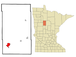
According to the United States Census Bureau, the city has an area of 6.81 square miles (17.64 km2), of which 6.59 square miles (17.07 km2) is land and 0.22 square miles (0.57 km2) is water. [13] The Fish Hook River flows through the city, which is surrounded by three lakes: Fish Hook, Long, and Potato. [14]

Climate

Park Rapids has a humid continental climate (Köppen Dwb), with warm summers and long, cold snowy winters.

Climate data for Park Rapids Municipal Airport, Minnesota (1991–2020 normals, extremes 1893–present)
MonthJanFebMarAprMayJunJulAugSepOctNovDecYear
Record high °F (°C)58
(14)
61
(16)
80
(27)
96
(36)
99
(37)
105
(41)
107
(42)
103
(39)
99
(37)
90
(32)
73
(23)
60
(16)
107
(42)
Mean daily maximum °F (°C)18.1
(−7.7)
23.8
(−4.6)
36.9
(2.7)
52.6
(11.4)
66.5
(19.2)
75.7
(24.3)
80.2
(26.8)
78.6
(25.9)
69.2
(20.7)
53.6
(12.0)
36.4
(2.4)
23.1
(−4.9)
51.2
(10.7)
Daily mean °F (°C)7.6
(−13.6)
12.3
(−10.9)
26.3
(−3.2)
41.0
(5.0)
54.2
(12.3)
64.2
(17.9)
68.7
(20.4)
66.7
(19.3)
57.8
(14.3)
43.6
(6.4)
27.9
(−2.3)
14.2
(−9.9)
40.4
(4.7)
Mean daily minimum °F (°C)−2.8
(−19.3)
0.8
(−17.3)
15.6
(−9.1)
29.3
(−1.5)
41.9
(5.5)
52.8
(11.6)
57.1
(13.9)
54.8
(12.7)
46.3
(7.9)
33.5
(0.8)
19.3
(−7.1)
5.4
(−14.8)
29.5
(−1.4)
Record low °F (°C)−47
(−44)
−51
(−46)
−38
(−39)
−8
(−22)
14
(−10)
27
(−3)
35
(2)
31
(−1)
17
(−8)
−3
(−19)
−32
(−36)
−46
(−43)
−51
(−46)
Average precipitation inches (mm)0.43
(11)
0.40
(10)
1.00
(25)
1.72
(44)
3.09
(78)
4.08
(104)
3.93
(100)
2.78
(71)
2.70
(69)
2.40
(61)
0.81
(21)
0.52
(13)
23.86
(606)
Average precipitation days (≥ 0.01 in)5.64.76.67.811.712.411.710.110.09.96.16.8103.4
Source: NOAA [15] [16]

Demographics

Hubbard County Courthouse Hubbard County Courthouse E.jpg
Hubbard County Courthouse
Historical population
CensusPop.Note
1900 1,313
1910 1,80137.2%
1920 1,603−11.0%
1930 2,08129.8%
1940 2,64327.0%
1950 3,02714.5%
1960 3,0470.7%
1970 2,772−9.0%
1980 2,9767.4%
1990 2,863−3.8%
2000 3,27614.4%
2010 3,70913.2%
2020 4,14211.7%
2022 (est.)4,269 [3] 3.1%
U.S. Decennial Census [17]
2020 Census [2]

2010 census

As of the census of 2010, there were 3,709 people, 1,772 households, and 892 families residing in the city. The population density was 562.8 inhabitants per square mile (217.3/km2). There were 2,003 housing units at an average density of 303.9 per square mile (117.3/km2). The racial makeup of the city was 94.1% White, 0.4% African American, 2.3% Native American, 0.1% Asian, 1.2% from other races, and 1.9% from two or more races. Hispanic or Latino of any race were 3.7% of the population.

There were 1,772 households, of which 24.7% had children under the age of 18 living with them, 35.2% were married couples living together, 11.6% had a female householder with no husband present, 3.5% had a male householder with no wife present, and 49.7% were non-families. 44.9% of all households were made up of individuals, and 22.5% had someone living alone who was 65 years of age or older. The average household size was 2.03 and the average family size was 2.80.

The median age in the city was 43.1 years. 22.1% of residents were under the age of 18; 8.4% were between the ages of 18 and 24; 21.7% were from 25 to 44; 22.8% were from 45 to 64; and 24.9% were 65 years of age or older. The gender makeup of the city was 46.3% male and 53.7% female.

2000 census

As of the census of 2000, there were 3,276 people, 1,476 households, and 788 families residing in the city. The population density was 547.5 inhabitants per square mile (211.4/km2). There were 1,616 housing units at an average density of 270.1 per square mile (104.3/km2). The racial makeup of the city was 95.97% White, 0.31% African American, 2.20% Native American, 0.37% Asian, 0.03% Pacific Islander, 0.46% from other races, and 0.67% from two or more races. Hispanic or Latino of any race were 1.07% of the population.

There were 1,476 households, out of which 25.3% had children under the age of 18 living with them, 39.2% were married couples living together, 10.8% had a female householder with no husband present, and 46.6% were non-families. 41.8% of all households were made up of individuals, and 23.3% had someone living alone who was 65 years of age or older. The average household size was 2.11 and the average family size was 2.88.

In the city, the population was spread out, with 23.5% under the age of 18, 7.8% from 18 to 24, 21.9% from 25 to 44, 18.8% from 45 to 64, and 28.1% who were 65 years of age or older. The median age was 42 years. For every 100 females, there were 81.7 males. For every 100 females age 18 and over, there were 77.3 males.

The median income for a household in the city was $23,628, and the median income for a family was $33,958. Males had a median income of $28,718 versus $21,827 for females. The per capita income for the city was $16,416. About 11.6% of families and 12.2% of the population were below the poverty line, including 11.3% of those under age 18 and 13.1% of those age 65 or over. [18]

Notable people

Park Rapids is the birthplace of two notable authors, Will Weaver and Nathan Aaseng. Weaver was born to a farming family and educated at Saint Cloud State University, the University of Minnesota, and Stanford University. He worked as a farmer, an educator, and a fiction writer. Three of his best-known novels are Striking Out,Farm Team, and Hard Ball. They reflect Weaver's upbringing on a northern Minnesota farm. His writings have won several awards, including the Friends of American Writers Award (1989) and the Minnesota Book Award for Fiction (1989). Weaver now lives in Bemidji. [19]

Aaseng was the son of a minister and attended Luther College and Luther Seminary. He worked as a microbiologist-biochemist and wrote juvenile nonfiction and fiction. His works include more than 130 books on a variety of subjects. Some examples are Big Red,Wild Trek, and the "You Are the Coach" series. [20]

Minnesota newspaper editor and legislator John A. Ainley, Jr., lived in Park Rapids. [21]

Iowa newspaper editor and legislator Thomas Miller was born in Park Rapids. [22]

Businesswoman and Minnesota state legislator Esther Miriam Fieldman lived in Park Rapids. [23]

Four-time U.S. Paralympian Aaron Pike was born in Park Rapids and spent his first year there before moving away for his father's military career. Pike continued to return to Park Rapids each summer and continues to list it as his hometown. He competes in wheelchair racing and Nordic skiing. [24]

Recreation

The official start of the Heartland Trail is at Park Rapids' Heartland Park, which has shelters, restrooms, a swimming beach and a bridge across the Fish Hook River. Red Bridge Park, city of Park Rapids, Minnesota.jpg
The official start of the Heartland Trail is at Park Rapids’ Heartland Park, which has shelters, restrooms, a swimming beach and a bridge across the Fish Hook River.

There are over 70 lakes in the Park Rapids area, which all offer distinct fishing opportunities. Some notable nearby lakes include Lake Itasca (headwaters of the Mississippi River) as well as some of the numerous Crow Wing Lakes. Some of the most common fish caught in the area include largemouth, smallmouth and rock bass, bullhead, crappie, northern pike, perch, sunfish and walleye. [25] The Heartland Trail, one of the oldest rail-to-trail projects in the United States, [7] begins in Park Rapids. The 49-mile trail is open to horseback riding, hiking, snowmobiling, and biking at different segments throughout. Deer, coyote, grey wolf, chipmunks, bobcat, bear, bald eagle, red fox, raccoon, beaver and muskrat can all be spotted along the trail.

Two residents of Park Rapids, watching the July 4th Parade on Main street July 4th Park Rapids Parade.jpg
Two residents of Park Rapids, watching the July 4th Parade on Main street

Local media

Park Rapids is home to De La Hunt Broadcasting, east of the city's downtown. There are three radio stations in Park Rapids:

Park Rapids receives five television stations:

The local cable TV provider is Arvig Communication Systems.

Newspaper

The Forum Communications Company of Fargo, North Dakota, owns and operates the Park Rapids Enterprise , published twice weekly. [26]

Education

Park Rapids Area High School, at 401 Huntsinger Avenue, serves grades 9–12. [27] Century School, at 501 Helten Avenue, houses grades K–8. [28]

Park Rapids had two separate buildings for primary school that split up K–4 and 9–12 from grades 5–8. Frank White Elementary and Park Rapids High School were part of the same building. The Century School was built in 2001 to accommodate grades K–8. The Frank White Elementary School was remodeled and pieces of it became part of the Park Rapids Area High School, while several of the Frank White classrooms became preschool classrooms. The old Park Rapids Middle School was sold several times and part of it is now apartments.

Related Research Articles

<span class="mw-page-title-main">Wadena County, Minnesota</span> County in Minnesota, United States

Wadena County is a county in the U.S. state of Minnesota. As of the 2020 census, the population was 14,065. Its county seat is Wadena.

<span class="mw-page-title-main">Wilton, Iowa</span> City in Iowa, United States

Wilton is a city in Cedar and Muscatine counties in the U.S. state of Iowa. The population was 2,924 at the time of the 2020 census. The Muscatine County portion of Wilton is part of the Muscatine Micropolitan Statistical Area.

<span class="mw-page-title-main">Campbellsville, Kentucky</span> City in Kentucky, United States

Campbellsville is a city in central Kentucky founded in 1817 by Andrew Campbell. It is known for Campbellsville University, Taylor Regional Hospital health care system, its historic downtown, and the proximity to Green River Lake State Park. Campbellsville is the county seat of Taylor County, with a geographic boundary shaped like a heart. Campbellsville celebrated its bicentennial on July 4, 2017.

<span class="mw-page-title-main">Comstock Park, Michigan</span> Census-designated place & unincorporated community in Michigan, United States

Comstock Park is an unincorporated community and census-designated place (CDP) in Kent County in the U.S. state of Michigan. The population was 10,500 at the 2020 census. The community is located within Alpine Township to the west and Plainfield Township to the east.

<span class="mw-page-title-main">Big Rapids, Michigan</span> City in Michigan, United States

Big Rapids is a city and the county seat of Mecosta County, Michigan. The population was 7,727 at the 2020 census, down from 10,601 in 2010. The city is located within Big Rapids Township, but it is politically independent. Big Rapids is home of the main campus of Ferris State University, a four-year public university.

<span class="mw-page-title-main">Reed City, Michigan</span> City in Michigan, United States

Reed City is a city in the U.S. state of Michigan. The population was 2,490 at the 2020 census. It is located in southwestern Osceola County and is the county seat.

Bemidji Township is a township in Beltrami County, Minnesota, United States. The population was 2,884 as of the 2020 census, down from 3,134 recorded in 2010.

<span class="mw-page-title-main">Rice, Minnesota</span> City in Minnesota, United States

Rice is a city in Benton County, Minnesota, United States. The population was 1,275 at the 2010 census. Its zip code also encompasses Graham, Langola, and Watab townships.

<span class="mw-page-title-main">Rushford, Minnesota</span> City in Minnesota, United States

Rushford is a city in Fillmore County, Minnesota, United States. The population was 1,860 at the 2020 census.

<span class="mw-page-title-main">Brooklyn Park, Minnesota</span> City in Minnesota, United States

Brooklyn Park is a suburban city on the west bank of the Mississippi River, upstream from downtown Minneapolis in northern Hennepin County. It is the sixth-largest city in the U.S. state of Minnesota. The population was 86,478 at the 2020 census. The city still has undeveloped land and farms, including the historic Eidem Homestead, a 1900s working farm that is a popular tourist attraction for families and school field trips. Brooklyn Park is considered both a second- and third-tier suburb of Minneapolis, because much of the land north of 85th Avenue was developed after 2000.

<span class="mw-page-title-main">Akeley, Minnesota</span> City in Minnesota, United States

Akeley is a city in Hubbard County, Minnesota, United States. The population was 404 at the 2020 census.

<span class="mw-page-title-main">Nevis, Minnesota</span> City in Minnesota, United States

Nevis is a city in Hubbard County, Minnesota, United States. The population was 377 at the 2020 census.

<span class="mw-page-title-main">Grand Rapids, Minnesota</span> City in Minnesota, United States

Grand Rapids is a city in Itasca County, Minnesota, United States, and it is the county seat. The population was 11,126 at the 2020 census. The city is named for the 3.5-mile (5.6 km) long rapids in the Mississippi River which was the uppermost limit of practical steamboat travel during the late 19th century. Today the rapids are hidden below the dam of UPM Paper Company.

<span class="mw-page-title-main">Sandstone, Minnesota</span> City in Minnesota, United States

Sandstone is a city in Pine County, Minnesota, United States, along the Kettle River. The population was 2,849 at the 2010 census.

<span class="mw-page-title-main">Coon Rapids, Minnesota</span> City in Minnesota, United States

Coon Rapids is a northern suburb of Minneapolis, and is the second-largest city by population in Anoka County, Minnesota, United States. The population was 63,599 at the 2020 census, making it the fifteenth largest city in Minnesota and the seventh largest Twin Cities suburb.

<span class="mw-page-title-main">Sauk Rapids, Minnesota</span> City in Minnesota, United States

Sauk Rapids is a city in Benton County, Minnesota, United States. The population was 13,862 at the 2020 census and is 13,896 according to 2021 census estimates, about a third of Benton County's population. It is on a set of rapids on the Mississippi River near its confluence with the Sauk River.

Wilkinson Township is a township in Cass County, Minnesota, United States. The population was 270 as of the 2000 census.

<span class="mw-page-title-main">Falcon Heights, Minnesota</span> City in Minnesota, United States

Falcon Heights is a suburb of Saint Paul and a city in Ramsey County, Minnesota, United States. The population was 5,321 at the 2010 census. It became a village in 1949 and a city in 1973.

<span class="mw-page-title-main">Sartell, Minnesota</span> City in Minnesota, United States

Sartell is a city in Benton and Stearns Counties in the U.S. state of Minnesota that straddles the Mississippi River. It is part of the St. Cloud Metropolitan Statistical Area. The population was 19,351 at the 2020 census, making it St. Cloud's most populous suburb and the fourth-largest city in central Minnesota, after St. Cloud, Elk River, and Willmar.

<span class="mw-page-title-main">Braham, Minnesota</span> City in Minnesota, United States

Braham is a city in Isanti and Kanabec counties in the U.S. state of Minnesota. The population was 1,769 at the 2020 census.

References

  1. "2020 U.S. Gazetteer Files". United States Census Bureau. Retrieved July 24, 2022.
  2. 1 2 3 "Explore Census Data". United States Census Bureau . Retrieved November 19, 2023.
  3. 1 2 "City and Town Population Totals: 2020-2022". United States Census Bureau. November 19, 2023. Retrieved November 19, 2023.
  4. "US Board on Geographic Names". United States Geological Survey. October 25, 2007. Retrieved January 31, 2008.
  5. "Find a County". National Association of Counties. Archived from the original on May 31, 2011. Retrieved June 7, 2011.
  6. Minnesota Department of Natural Resources Archived April 3, 2008, at the Wayback Machine . 2008. The Minnesota Department of Natural Resources Web Site (online). Accessed November 25, 2008 at http://www.dnr.state.mn.us/sitetools/copyright.html
  7. 1 2 "Heartland State Trail: Minnesota" . Retrieved April 2, 2012.
  8. 1 2 Warren Upham, (2008). Minnesota Geographic Names: Their Origin and Historic Significance. Minnesota Historical Society, 1920. Harvard University. Digitized Aug 8, 2007. pp. 244
  9. City of Park Rapids. 2008. The city of Park Rapids, MN Web site (online). Accessed December 2, 2008 at City of Park Rapids
  10. Park Rapids "Park Rapids Municipal-Konshok Field Airport." AirNav.com. AirNav, LLC. Web. March 30, 2012.
  11. "Hubbard County." Public Transit in Minnesota. Minnesota Department of Transportation, 2012. Web. March 30, 2012.
  12. City of Park Rapids. 2008. The city of Park Rapids, MN Web site (online). Accessed December 2, 2008.
  13. "US Gazetteer files 2010". United States Census Bureau. Archived from the original on July 2, 2012. Retrieved November 13, 2012.
  14. Minnesota Atlas & Gazetteer. Yarmouth, Me.: DeLorme. 1994. p. 61. ISBN   0-89933-222-6.
  15. "NowData – NOAA Online Weather Data". National Oceanic and Atmospheric Administration. Retrieved June 23, 2021.
  16. "Station: Park Rapids Muni AP, MN". U.S. Climate Normals 2020: U.S. Monthly Climate Normals (1991-2020). National Oceanic and Atmospheric Administration. Retrieved June 23, 2021.
  17. United States Census Bureau. "Census of Population and Housing" . Retrieved July 18, 2014.
  18. "U.S. Census website". United States Census Bureau . Retrieved January 31, 2008.
  19. "Weaver, Will(iam (Weller) (1950-)." UXL DISCovering Authors (online). Discovering Collection. Gale. 2003. Retrieved March 23, 2012.
  20. "Aaseng, Nathan (1953-)." UXL DISCovering Authors (online). Discovering Collection. Gale. 2003. Retrieved March 23, 2012.
  21. 'John Ainley, former legislator and newspaper editor, dies,' Minneapolis Star Tribune, Kavita Kumar, May 4, 2001
  22. 'William H. Miller-obituary,' Cherokee Daily Times, May 31, 2001, pg. 2
  23. 'Esther Miriam Fieldman-obituary,' Minneapolis Star-Tribune, July 2, 2007
  24. Aaron Pike Team USA
  25. Billig, James (1994). Park Rapids Area Fishing Map Guide. Duluth: Sportsman's Connection.
  26. "Park Rapids Enterprise". Park Rapids Enterprise. June 14, 2021.
  27. "Park Rapids Area High School." Archived February 11, 2012, at the Wayback Machine Park Rapids Area School District 309. 2011. Retrieved April 25, 2012
  28. "Century Elementary." Archived December 8, 2011, at the Wayback Machine Park Rapids Area School District 309. 2011. Retrieved April 25, 2012

46°55′N95°03′W / 46.917°N 95.050°W / 46.917; -95.050