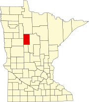
Badoura Township, Hubbard County, Minnesota

Last updated

Badoura Township, Minnesota
USA Minnesota location map.svg
Red pog.svg
Badoura Township, Minnesota
Location within the state of Minnesota
Usa edcp location map.svg
Red pog.svg
Badoura Township, Minnesota
Badoura Township, Minnesota (the United States)
Coordinates: 46°51′21″N94°43′46″W / 46.85583°N 94.72944°W / 46.85583; -94.72944
Country United States
State Minnesota
County Hubbard
Area
  Total36.5 sq mi (94.5 km2)
  Land35.5 sq mi (91.9 km2)
  Water1.0 sq mi (2.6 km2)
Elevation
1,414 ft (431 m)
Population
 (2000)
  Total101
  Density2.8/sq mi (1.1/km2)
Time zone UTC-6 (Central (CST))
  Summer (DST) UTC-5 (CDT)
FIPS code 27-03178 [1]
GNIS feature ID0663492 [2]

Badoura Township is a township in Hubbard County, Minnesota, United States. The population was 101 at the 2000 census.

Contents

Badoura Township was named for Mary Badoura Mow, the wife of an early settler. [3]

Geography

According to the United States Census Bureau, the township has a total area of 36.5 square miles (95 km2), of which 35.5 square miles (92 km2) is land and 1.0 square mile (2.6 km2) (2.74%) is water.

Minnesota State Highways 64 and 87 are two of the main routes in the community.

Demographics

As of the census [1] of 2000, there were 101 people, 41 households, and 30 families residing in the township. The population density was 2.8 inhabitants per square mile (1.1/km2). There were 113 housing units at an average density of 3.2 per square mile (1.2/km2). The racial makeup of the township was 99.01% White and 0.99% Asian. Hispanic or Latino of any race were 0.99% of the population.

There were 41 households, out of which 24.4% had children under the age of 18 living with them, 70.7% were married couples living together, 2.4% had a female householder with no husband present, and 24.4% were non-families. 22.0% of all households were made up of individuals, and 12.2% had someone living alone who was 65 years of age or older. The average household size was 2.46 and the average family size was 2.87.

In the township the population was spread out, with 17.8% under the age of 18, 7.9% from 18 to 24, 20.8% from 25 to 44, 26.7% from 45 to 64, and 26.7% who were 65 years of age or older. The median age was 48 years. For every 100 females, there were 102.0 males. For every 100 females age 18 and over, there were 107.5 males.

The median income for a household in the township was $31,875, and the median income for a family was $37,813. Males had a median income of $25,000 versus $37,917 for females. The per capita income for the township was $13,465. About 9.5% of families and 17.5% of the population were below the poverty line, including 54.5% of those under the age of 18 and none of those 65 and older.

Related Research Articles

Bull Moose Township is a township in Cass County, Minnesota, United States. The population was 107 as of the 2000 census. This township was named after the Bull Moose Party.

Deerfield Township is a township in Cass County, Minnesota, United States. The population was 154 as of the 2000 census. Deerfield Township was named for the large population of deer within its borders.

Hiram Township is a township in Cass County, Minnesota, United States. The population was 334 as of the 2000 census. Hiram Township was named for Hiram Wilson, a pioneer settler.

McKinley Township is a township in Cass County, Minnesota, United States. The population was 130 at the 2000 census. McKinley Township was named for William McKinley, 25th President of the United States.

Big Bend Township is a township in Chippewa County, Minnesota, United States. The population was 257 at the 2000 census.

Verona Township is a township in Faribault County, Minnesota, United States. The population was 391 at the 2000 census.

Cherry Grove Township is a township in Goodhue County, Minnesota, United States. The population was 430 at the 2000 census.

Ewington Township is a township in Jackson County, Minnesota, United States. The population was 233 at the 2000 census.

Elm Creek Township is a township in Martin County, Minnesota, United States. The population was 209 at the 2000 census.

Green Prairie Township is a township in Morrison County, Minnesota, United States. The population was 665 at the 2000 census.

Platte Township is a township in Morrison County, Minnesota, United States. The population was 329 at the 2000 census.

Pulaski Township is a township in Morrison County, Minnesota, United States. The population was 340 at the 2000 census.

Clitherall Township is a township in Otter Tail County, Minnesota, United States. The population was 549 at the 2000 census.
<span class="mw-page-title-main">Deer Creek Township, Otter Tail County, Minnesota</span> Township in Minnesota, United States

Deer Creek Township is a township in Otter Tail County, Minnesota, United States. The population was 348 at the 2000 census.

Elizabeth Township is a township in Otter Tail County, Minnesota, United States. The population was 722 at the 2000 census.

Girard Township is a township in Otter Tail County, Minnesota, United States. The population was 697 at the 2000 census.

Hobart Township is a township in Otter Tail County, Minnesota, United States. The population was 733 at the 2000 census.

Finlayson Township is a township in Pine County, Minnesota, United States. The population was 506 at the 2000 census. The township's original extent was reduced when the city of Finlayson was incorporated and separated from it.

Rosebud Township is a township in Polk County, Minnesota, United States. It is part of the Grand Forks-ND-MN Metropolitan Statistical Area. The population was 343 at the 2000 census.

Meadow Township is a township in Wadena County, Minnesota, United States. The population was 228 at the 2000 census.

References

  1. 1 2 "U.S. Census website". United States Census Bureau . Retrieved January 31, 2008.
  2. "US Board on Geographic Names". United States Geological Survey. October 25, 2007. Retrieved January 31, 2008.
  3. Upham, Warren (1920). Minnesota Geographic Names: Their Origin and Historic Significance. Minnesota Historical Society. p.  243.