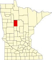
Steamboat River Township, Hubbard County, Minnesota

Last updated
Steamboat River Township, Minnesota
USA Minnesota location map.svg
Red pog.svg
Steamboat River Township, Minnesota
Location within the state of Minnesota
Usa edcp location map.svg
Red pog.svg
Steamboat River Township, Minnesota
Steamboat River Township, Minnesota (the United States)
Coordinates: 47°8′9″N94°41′56″W / 47.13583°N 94.69889°W / 47.13583; -94.69889 Coordinates: 47°8′9″N94°41′56″W / 47.13583°N 94.69889°W / 47.13583; -94.69889
Country United States
State Minnesota
County Hubbard
Area
  Total36.0 sq mi (93.2 km2)
  Land34.5 sq mi (89.4 km2)
  Water1.5 sq mi (3.8 km2)
Elevation
1,463 ft (446 m)
Population
 (2000)
  Total123
  Density3.6/sq mi (1.4/km2)
Time zone UTC-6 (Central (CST))
  Summer (DST) UTC-5 (CDT)
FIPS code 27-62618 [1]
GNIS feature ID0665703 [2]

Steamboat River Township is a township in Hubbard County, Minnesota, United States. The population was 123 at the 2000 census.

Contents

Geography

According to the United States Census Bureau, the township has a total area of 36.0 square miles (93.2 km2), of which 34.5 square miles (89.4 km2) is land and 1.5 square miles (3.8 km2) (4.03%) is water.

Demographics

As of the census [1] of 2000, there were 123 people, 50 households, and 43 families residing in the township. The population density was 3.6 people per square mile (1.4/km2). There were 121 housing units at an average density of 3.5/sq mi (1.4/km2). The racial makeup of the township was 96.75% White, 0.81% African American, 1.63% Native American and 0.81% Asian.

There were 50 households, out of which 28.0% had children under the age of 18 living with them, 80.0% were married couples living together, 4.0% had a female householder with no husband present, and 14.0% were non-families. 12.0% of all households were made up of individuals, and 6.0% had someone living alone who was 65 years of age or older. The average household size was 2.46 and the average family size was 2.67.

In the township the population was spread out, with 22.0% under the age of 18, 4.1% from 18 to 24, 22.8% from 25 to 44, 26.8% from 45 to 64, and 24.4% who were 65 years of age or older. The median age was 47 years. For every 100 females, there were 108.5 males. For every 100 females age 18 and over, there were 113.3 males.

The median income for a household in the township was $42,750, and the median income for a family was $43,500. Males had a median income of $30,417 versus $43,333 for females. The per capita income for the township was $20,335. There were 6.8% of families and 7.2% of the population living below the poverty line, including 17.6% of under eighteens and none of those over 64.

Related Research Articles

Waukenabo Township is a township in Aitkin County, Minnesota, United States. The population was 316 as of the 2010 census.

Beauford Township is a township in Blue Earth County, Minnesota, United States. The population was 442 as of the 2000 census.

Minerva Township is a township in Clearwater County, Minnesota, United States. The population was 283 at the 2000 census.

Rice Township is a township in Clearwater County, Minnesota, United States. The population was 134 at the 2000 census. Rice Township was named after the Wild Rice River.

Gail Lake Township is a township in Crow Wing County, Minnesota, United States. The population was 92 at the 2000 census.

Alvwood Township is a township in Itasca County, Minnesota, United States. The population was 42 at the 2010 census.

Limestone Township is a township in Lincoln County, Minnesota, United States. The population was 159 at the 2000 census.

Monroe Township is a township in Lyon County, Minnesota, United States. The population was 242 at the 2000 census.

Clover Township is a township in Mahnomen County, Minnesota, United States. The population was 123 at the 2000 census.

Mudgett Township is a township in Mille Lacs County, Minnesota, United States. The population was 84 at the 2010 census.

<span class="mw-page-title-main">Racine, Minnesota</span> City in Minnesota, United States

Racine is a city in Racine Township, Mower County, Minnesota, United States. The population was 442 at the 2010 census.

Star Lake Township is a township in Otter Tail County, Minnesota, United States. The population was 410 at the 2000 census.

Clover Township is a township in Pine County, Minnesota, United States. The population was 316 at the 2000 census.

Palmville Township is a township in Roseau County, Minnesota, United States. The population was 55 at the 2000 census. The town was named for Louis Palm, a Swedish settler.

Livonia Township is a township in Sherburne County, Minnesota, United States. The population was 3,917 at the 2000 census.

Camp 5 Township is a township in Saint Louis County, Minnesota, United States. The population was 35 at the 2010 census.

Connelly Township is a township in Wilkin County, Minnesota, United States. The population was 123 according to the 2000 census.

<span class="mw-page-title-main">Spring Brook Township, Lackawanna County, Pennsylvania</span> Place in Pennsylvania, United States

Spring Brook Township is a township in Lackawanna County, Pennsylvania, United States. The population was 2,753 at the 2020 census.
<span class="mw-page-title-main">Shrewsbury Township, Sullivan County, Pennsylvania</span> Township in Pennsylvania, United States

Shrewsbury Township is a township in Sullivan County, Pennsylvania, United States. The population was 303 at the 2020 census.

<span class="mw-page-title-main">Salem Township, Westmoreland County, Pennsylvania</span> Township in Pennsylvania, United States

Salem Township is a township in Westmoreland County, Pennsylvania, United States. The population was 6,083 at the 2020 census.

References

  1. 1 2 "U.S. Census website". United States Census Bureau . Retrieved 2008-01-31.
  2. "US Board on Geographic Names". United States Geological Survey. 2007-10-25. Retrieved 2008-01-31.