Martin, Minnesota

Last updated
Martin
USA Minnesota location map.svg
Red pog.svg
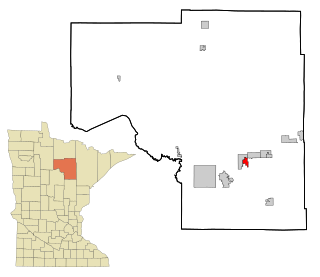
Martin
Location of the community of Martin
within Balsam Township, Itasca County
Usa edcp location map.svg
Red pog.svg
Martin
Martin (the United States)
Coordinates: 47°29′22″N93°32′40″W / 47.48944°N 93.54444°W / 47.48944; -93.54444 Coordinates: 47°29′22″N93°32′40″W / 47.48944°N 93.54444°W / 47.48944; -93.54444
Country United States
State Minnesota
County Itasca
Township Balsam Township
Elevation
1,325 ft (404 m)
Population
  Total70
Time zone UTC-6 (Central (CST))
  Summer (DST) UTC-5 (CDT)
ZIP code
55709
Area code(s) 218
GNIS feature ID659367 [1]

Martin is an unincorporated community in Balsam Township, Itasca County, Minnesota, United States.

Unincorporated area Region of land not governed by own local government

In law, an unincorporated area is a region of land that is not governed by a local municipal corporation; similarly an unincorporated community is a settlement that is not governed by its own local municipal corporation, but rather is administered as part of larger administrative divisions, such as a township, parish, borough, county, city, canton, state, province or country. Occasionally, municipalities dissolve or disincorporate, which may happen if they become fiscally insolvent, and services become the responsibility of a higher administration. Widespread unincorporated communities and areas are a distinguishing feature of the United States and Canada. In most other countries of the world, there are either no unincorporated areas at all, or these are very rare; typically remote, outlying, sparsely populated or uninhabited areas.

Balsam Township, Itasca County, Minnesota Township in Minnesota, United States

Balsam Township is a township in Itasca County, Minnesota, United States. The population was 550 at the 2010 census.

Itasca County, Minnesota County in the United States

Itasca County is a county located in the State of Minnesota. As of the 2010 United States Census, the population was 45,058. Its county seat is Grand Rapids. The county is named after Lake Itasca, which is in turn a shortened version of the Latin words veritas caput, meaning 'truth' and 'head', a reference to the source of the Mississippi River. Portions of the Bois Forte and Leech Lake Indian reservations are in the county.

The community is northwest of Bovey, near the junction of Itasca County Roads 49 and 50. County Road 326 is also in the area.

Nearby places include Trout Lake and Spider Lake. Martin is 23 miles northwest of Bovey; and 22 miles north of Grand Rapids. It is 14 miles southeast of Marcell; and 25 miles southeast of Bigfork.

Bovey, Minnesota City in Minnesota, United States

Bovey is a city in Itasca County, Minnesota, United States. It is part of Minnesota's Iron Range. The population was 804 at the 2010 census.

Grand Rapids, Minnesota City in Minnesota, United States

Grand Rapids is a city in Itasca County, Minnesota, United States. The population was 10,869 at the 2010 census. It is the county seat of Itasca County.

Marcell, Minnesota Unincorporated community in Minnesota, United States

Marcell is an unincorporated community in Marcell Township, Itasca County, Minnesota, United States.

Martin is within ZIP code 55709 based in Bovey. The community is within the Chippewa National Forest. Martin is n the southwest portion of Balsam Township.

Chippewa National Forest

Chippewa National Forest is a National Forest located in northcentral Minnesota, United States, in the counties of Itasca, Cass and Beltrami. Forest headquarters are located in Cass Lake, Minnesota. There are local ranger district offices in Blackduck, Deer River and Walker.

Related Research Articles

Cedar Valley Township, St. Louis County, Minnesota Township in Minnesota, United States

Cedar Valley Township is a township in Saint Louis County, Minnesota, United States. Cedar Valley Township was named for the white cedar in the valley of the Floodwood River. The population was 195 at the 2010 census.

Bear River, Minnesota Unincorporated community in Minnesota, United States

Bear River is an unincorporated community in Itasca and Saint Louis counties in the U.S. state of Minnesota.

Swan River, Itasca County, Minnesota Unincorporated community in Minnesota, United States

Swan River is an unincorporated community in southeast Itasca County, Minnesota, United States.

Goodland, Minnesota Unincorporated community in Minnesota, United States

Goodland is an unincorporated community in Goodland Township, Itasca County, Minnesota, United States.

Spring Lake, Itasca County, Minnesota Unincorporated community in Minnesota, United States

Spring Lake is an unincorporated community in Lake Jessie Township, Itasca County, Minnesota, United States; located within the Chippewa National Forest.

Max, Minnesota Unincorporated community in Minnesota, United States

Max is an unincorporated community in Max Township, Itasca County, Minnesota, United States; located within the Chippewa National Forest and the Leech Lake Indian Reservation.

Wirt, Minnesota Unincorporated community in Minnesota, United States

Wirt is an unincorporated community in Wirt Township, Itasca County, Minnesota, United States; located within the Chippewa National Forest.

Wawina, Minnesota Unincorporated community in Minnesota, United States

Wawina is an unincorporated community in Wawina Township, Itasca County, Minnesota, United States.

Blackberry, Minnesota Unincorporated community in Minnesota, United States

Blackberry is an unincorporated community in Blackberry Township, Itasca County, Minnesota, United States.

Alvwood, Minnesota Unincorporated community in Minnesota, United States

Alvwood is an unincorporated community in Alvwood Township, Itasca County, Minnesota, United States.

Bergville, Minnesota Unincorporated community in Minnesota, United States

Bergville is an unincorporated community in Ardenhurst Township, Itasca County, Minnesota, United States; located within the Chippewa National Forest.

Bass Lake, Itasca County, Minnesota Unincorporated community in Minnesota, United States

Bass Lake is an unincorporated community in Wirt Township, Itasca County, Minnesota, United States; located within the Chippewa National Forest. The community is located between Wirt and Talmoon at the junction of Itasca County Roads 29 and 127.

Dunbar, Minnesota Unincorporated community in Minnesota, United States

Dunbar is an unincorporated community in Good Hope Township, Itasca County, Minnesota, United States. The community is located northwest of Squaw Lake at the junction of Itasca County Roads 32 and 149. State Highway 46 is nearby.

Dora Lake, Minnesota Unincorporated community in Minnesota, United States

Dora Lake is an unincorporated community in Kinghurst Township, Itasca County, Minnesota, United States; located within the Chippewa National Forest. The community is located near Wirt at the junction of Itasca County Roads 29 and 145.

Grattan, Minnesota Unincorporated community in Minnesota, United States

Grattan is an unincorporated community in Grattan Township, Itasca County, Minnesota, United States.

Orth, Minnesota Unincorporated community in Minnesota, United States

Orth is an unincorporated community in Nore Township, Itasca County, Minnesota, United States; located in the northwest corner of the county.

Jessie Lake, Minnesota Unincorporated community in Minnesota, United States

Jessie Lake is an unincorporated community in Lake Jessie Township, Itasca County, Minnesota, United States; located within the Chippewa National Forest. The community is located between Wirt and Talmoon; along Itasca County Road 4.

Rosy, Minnesota Unincorporated community in Minnesota, United States

Rosy is an unincorporated community in Third River Township, Itasca County, Minnesota, United States. The community is located northwest of Squaw Lake; near the junction of Itasca County Roads 32, 33, and 141.

Pomroy, Minnesota Unincorporated community in Minnesota, United States

Pomroy is an unincorporated community in Pomroy Township, Itasca County, Minnesota, United States.

References

  1. "Martin, Minnesota". Geographic Names Information System . United States Geological Survey.