
Tianjin, alternately romanized as Tientsin, is a municipality and a coastal metropolis in Northern China on the shore of the Bohai Sea. As such, it is not part of a province of China. It is one of the nine national central cities in Mainland China, with a total population of 13,866,009 inhabitants during the 2020 Chinese census. Its built-up area, made up of 12 central districts, was home to 11,165,706 inhabitants and is also the world's 29th-largest agglomeration and 11th-most populous city proper.

A ring road is a road or a series of connected roads encircling a town, city or country. The most common purpose of a ring road is to assist in reducing traffic volumes in the urban centre, such as by offering an alternate route around the city for drivers who do not need to stop in the city core. Ring roads can also serve to connect suburbs to each other, allowing efficient travel between them.

The Boulevard Périphérique, often called the Périph, is a controlled-access dual-carriageway ring road in Paris, France. With a few exceptions, it is situated along Paris's administrative limit.

The A61 is a major trunk road in England connecting Derby and Thirsk in North Yorkshire by way of Alfreton, Clay Cross, Chesterfield, Sheffield, Barnsley, Wakefield, Leeds, Harrogate and Ripon. The road is closely paralleled by the M1 motorway between Derby and Leeds.

The Beijing–Harbin Expressway, designated as G1 and commonly abbreviated as Jingha Expressway (京哈高速) is an expressway linking the cities of Beijing and Harbin, Heilongjiang.

Jingjintang Expressway, also known as the Jingtang Expressway, links Beijing via central Tianjin to the Tanggu District in eastern Tianjin. 143 kilometres in length, it crosses the jurisdictions of Beijing and Tianjin municipalities and Hebei province.
Beijing is a municipality located in North China at the northern tip of the North China Plain, near the meeting point of the Xishan and Yanshan mountain ranges. The city itself lies on flat land that opens to the east and south. The municipality's outlying districts and counties extend into the mountains that surround the city from the southwest to the northeast. The highest peaks are over 2,000 m (6,600 ft).

Beijing, as the capital and one of the four municipalities of the People's Republic of China (PRC), is a transport hub, with a sophisticated network of roads, railways and two major airports. Five completed ring roads encircle the city with nine expressways heading in virtually all compass directions, supplemented by eleven China National Highways.

The Leeds Inner Ring Road is part-motorway and part-A roads in Leeds, West Yorkshire, England, which forms a ring road around the city centre. It has six different road numbers that are all sections of longer roads. Clockwise, the roads are the A58(M), a motorway section of the A58 road; the A64(M), part of the A64 road; the A61 between York Road and the M621; the M621 between junctions 4 and 2; and the A643 between the M621 and A58. The motorway section is in total is 2.5 miles (4.0 km) long and is subject to a 40 miles per hour (64 km/h) speed limit throughout.

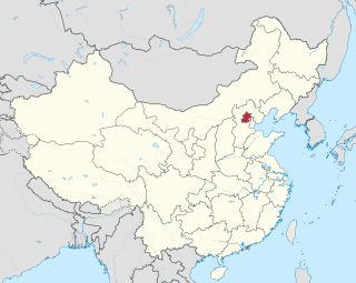
The Outer Ring Road in Tianjin, China is a city express road, 71.322 kilometres in length, which encircles Tianjin municipality.

Langfang is a prefecture-level city of Hebei Province, which was known as Tianjin Prefecture until 1973. It was renamed Langfang Prefecture after Tianjin became a municipality and finally upgraded into a prefecture-level city in 1988. Langfang is located approximately midway between Beijing and Tianjin. At the 2020 census, the population of Langfang was 5,464,087, of whom 1,147,591 lived in the built-up area made of Guangyang and Anci districts; its total area is around 6,417.28 km2 (2,477.73 sq mi). Langfang borders Baoding to the southwest, Cangzhou to the south, Beijing to the north and Tianjin to the east. Sanhe City and Dachang Hui County are now conurbated with Beijing, so that they form part of the same built-up area. Langfang is the smallest prefecture-level city of Hebei Province by land area.
The Middle Ring Road is a system of roads partly encircling the core of Tianjin. It is inside the Outer Ring Road, and encircles the Inner Ring Road. Originally, the road is not divided and has many traffic lights, but has interchanges at major roads. Today, most segments of the road has been upgraded to expressway standards, with the exception of the section that it shares with the Outer Ring Road in the northeast.

Johor Bahru Inner Ring Road, (JBIRR) or Jalan Lingkaran Dalam, Federal Route 188, is a multi-lane federal ring road highway that circles the Johor Bahru Central District in Johor, Malaysia. The 4.6-kilometre (2.9 mi) highway was the most expensive road infrastructure project per kilometre of its time in the country.

Queensway is the name of a number of roads in central Birmingham, England. The name most often refers to the Queensway tunnel, part of the A38. However the name is also used as a suffix of several other roads and circuses, such as Smallbrook Queensway and Colmore Circus Queensway; all of these were once part of the historic A4400 Inner Ring Road, which was often called collectively the Queensway.
Transport in Tianjin consists of an extensive network of roads and railways and a major airport. Bicycle is a major means of transport in daily use of the city.
Inner Ring Road may refer to:
European route E34 forms part of the United Nations International E-road network. It connects Zeebrugge, the major seaport of Bruges, with Bad Oeynhausen, a German spa town located beside the River Weser at the eastern edge of North Rhine-Westphalia. At Bad Oeynhausen the E34 links to the E30, a major pan European east-west artery. It also passes, relatively briefly, through the Netherlands, following the southern by-pass of Eindhoven. Within Germany the route follows from south-west to north-east the full length of North Rhine-Westphalia.

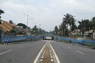
The Inner Ring Road (IRR), also known as Jawaharlal Nehru Salai or 100-Feet road or State Highway 2, is a major transportation corridor encircling the city of Chennai. It was developed by the Chennai Metropolitan Development Authority (CMDA). It is 25.2 km long with three distinct arms viz., Northern arm, Central arm and Southern arm, connecting SH 49A in Tiruvanmiyur, Velachery main road at Vijayanagar, NH 32 at Kathipara, NH 4 at Koyambedu, NH 205 at Padi, NH 5 at Madhavaram and joins SH 104 at Manali.

The Rongcheng–Wuhai Expressway, designated as G18 and commonly referred to as the Rongwu Expressway is an expressway that connects the cities of Rongcheng, Shandong, China, and Wuhai, Inner Mongolia. When fully complete, it will be 1,820 km (1,130 mi) in length.