
Padua is a city and comune (municipality) in Veneto, northern Italy, and the capital of the province of Padua. The city lies on the banks of the river Bacchiglione, 40 kilometres west of Venice and 29 km southeast of Vicenza, and has a population of 214,000. It is also the economic and communications hub of the area. Padua is sometimes included, with Venice and Treviso, in the Padua-Treviso-Venice Metropolitan Area (PATREVE) which has a population of around 2,600,000.

A ring road is a road or a series of connected roads encircling a town, city or country. The most common purpose of a ring road is to assist in reducing traffic volumes in the urban centre, such as by offering an alternate route around the city for drivers who do not need to stop in the city core. Ring roads can also serve to connect suburbs to each other, allowing efficient travel between them.
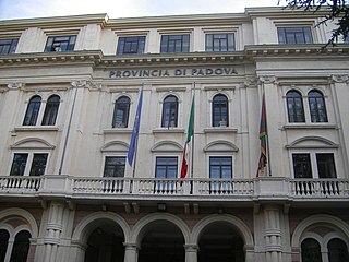
The province of Padua is a province in the Veneto region of Italy. Its capital is the city of Padua.
The autostrade are roads forming the Italian national system of motorways. The total length of the system is about 7,016 kilometres (4,360 mi), as of 30 July 2022. There are also 13 motorway spur routes, which extend for 355 kilometres (221 mi).

Bundesautobahn 1 is an autobahn in Germany. It runs from Heiligenhafen in Schleswig-Holstein to Saarbrücken, a distance of 749 km (465 mi), but is incomplete between Cologne and Trier. B 207 continues north from Heiligenhafen to Puttgarden, at the end of the island of Fehmarn, with a ferry to Rødby, Denmark.

The Moscow Automobile Ring Road, or MKAD (МКАД), is a ring road running predominantly on the city border of Moscow with a length of 108.9 km (67.7 mi) and 35 exits. It was completed in 1962. The speed limit is 100 km/h.

The autoroute system in France consists largely of toll roads. It is a network of 11,882 km (7,383 mi) of motorways as of 2014. On road signs, autoroute destinations are shown in blue, while destinations reached through a combination of autoroutes are shown with an added autoroute logo. Toll autoroutes are signalled with the word péage.

Novara is the capital city of the province of Novara in the Piedmont region in northwest Italy, to the west of Milan. With 101,916 inhabitants, it is the second most populous city in Piedmont after Turin. It is an important crossroads for commercial traffic along the routes from Milan to Turin and from Genoa to Switzerland. Novara lies between the streams Agogna and Terdoppio in northeastern Piedmont, 50 km (31 mi) from Milan and 95 km (59 mi) from Turin. It is only 15 km (9.3 mi) distant from the river Ticino, which marks the border with Lombardy region.

The A26 is a 357.6 km (222.2 mi) long French motorway connecting Calais and Troyes. It is also known as the Autoroute des Anglais as its length forms the first part of the main route from the Dover-Calais ferries and the Channel Tunnel towards Southern and Eastern France and the Cote d'Azur. The motorway is used by a high proportion of British cars, particularly during the summer holiday season. The A26 between Calais and Arras is part of one of the two main routes between London and Paris, the other being the A16.

Autostrada A90 or Grande Raccordo Anulare or GRA is a ring-shaped autostrada 68.2 kilometres (42.4 mi) long in Italy located in the region of Lazio that encircles Rome. It is a part of the E80 European route. GRA is one of the most important roads in Rome, and traffic reaches 160,000 vehicles per day as of 2011.

The Autostrada A4, or Autostrada Serenissima, is an autostrada 523.1 kilometres (325.0 mi) long in Italy located in the regions of Piedmont, Lombardy, Veneto and Friuli-Venezia Giulia which connects Turin and Trieste via Milan and Venice crossing the entire Po Valley from west to east.

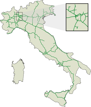
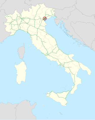
Autostrada A13 is an autostrada 116.7 kilometres (72.5 mi) long in Italy located in the regions of Veneto and Emilia-Romagna which connects Bologna to Padua, passing through Ferrara and Rovigo. Near the two extremities of the track are situated two of the biggest Italian freight villages, in Bologna and Padua. Snow tyres are compulsory from 15 November to 15 April on the whole highway track, according to the Italian directives.

The Autostrada A91, also called Autostrada Roma-Fiumicino, is an autostrada 18.5 kilometres (11.5 mi) long in Italy located in the region of Lazio which connects Rome to the Leonardo da Vinci–Fiumicino Airport in Fiumicino. It is a part of the E80 European route.
The Tangenziale di Mestre or Autostrada A57 is an autostrada 26.7 kilometres (16.6 mi) long in Italy located in the region of Veneto bypassing the urban center and suburban developments of Mestre. It was opened to traffic on 3 September 1972 and it is a part of the E55 European route.

The Autostrada RA15, also known as Raccordo autostradale 15 (RA 15; "Motorway connection 1") or Tangenziale di Catania ("Catania ring road") or Catania's By Pass (West), is an autostrada (Italian for "motorway") 23.3 kilometres (14.5 mi) long in Italy to contour Catania in Sicily, running from north to south, west of the city. It is managed by ANAS. It is a part of the E45 European route. The Raccordo autostradale 15 was opened on 28 May 1985 and was called T09 until the 1990s.

Via Cristoforo Colombo is a street in Rome (Italy) that links the historic centre to Ostia. Along most of its route, the street has three lanes for each direction of movement. With its 27 kilometres (17 mi) length it is the longest Italian road among those included within the borders of a single municipality and, in several stretches, the largest in Italy.

The Autostrada A22 or Autobrennero or Autostrada del Brennero is one of the most important autostrada in Italy, as it connects Po Valley, the city of Modena and the Autostrada A1 to Austria through the Brenner Pass, located in the municipality of Brenner. The Autostrada A22 is 315 kilometres (196 mi) long. It is a part of the E45 European route. The operator of the road is Autostrada del Brennero S.p.A.. The Autostrada A22 is located in the regions of Emilia-Romagna, Lombardy, Veneto and Trentino-Alto Adige/Südtirol.

Autostrada A50 or Tangenziale Ovest di Milano is an autostrada 31.8 kilometres (19.8 mi) long in Italy located in the region of Lombardy that connects the suburban area of Milan from south-east to north-west, managed by Milano Serravalle – Milano Tangenziali. It is a part of the E35 and E62 European routes.

Autostrada A52 or Tangenziale Nord di Milano is an autostrada 26.4 kilometres (16.4 mi) long in Italy located in the region of Lombardy and tangent to the city and suburban area of Milan that connects the northern suburban area of the city, managed by Milano Serravalle – Milano Tangenziali. On 29 March 2005, the second section to the west was opened, not connected to the original Autostrada A52, connecting the SS 33 and the Autostrada A8.