D0 motorway (Czech Republic)

Last updated • 5 min readFrom Wikipedia, The Free Encyclopedia
CZ traffic sign IS16a - D0.svg
D0 Motorway
Dálnice D0
Prague Ring
Pražský okruh
D0 motorway (Czech Republic)
Route information
Part of CZ traffic sign IS17 - E50.svg E50 CZ traffic sign IS17 - E65.svg E65
Length40 km (25 mi)
78 km (48 mi) / 90.8 km (56.4 mi)
Major junctions
Beltway around Prague
Major intersections
Route map
AB-Kreuz-blau.svg (planned)CZ traffic sign IS16a - D3.svgCZ traffic sign IS17 - E55.svg D 3  / E55
AB-AS-blau.svg (3) Vestec
AB-AS-blau.svg Zeichen 123.svg Písnice (under construction)
AB-Tunnel.svg Tunnel Komořany 1972 m
AB-AS-blau.svg Zeichen 123.svg Komořany (under construction)
AB-Brucke.svg Radotínský most 2045 m
AB-Fluss.svg Vltava
AB-Kreuz-blau.svg (10) Zbraslav SilniceI4.svg R 4
AB-Fluss.svg Berounka
AB-Tunnel.svg Tunnel Lochkov 1661 m
AB-Brucke.svg Lochkovský most 460 m
AB-AS-blau.svg (15)Lochkov
AB-AS-blau.svg (16)Slivenec
AB-AS-blau.svg (19)Ořech
AB-AS-blau.svg (21)Jinočany
AB-AS-blau.svg (23A)Chrášťany
AB-Kreuz-blau.svg (23)Třebonice CZ traffic sign IS16a - D5.svgCZ traffic sign IS17 - E50.svg D 5  / E50
AB-Kreuz-blau.svg (26) Řepy SilniceI6.svgCZ traffic sign IS17 - E48.svg R 6  / E48
AB-AS-blau.svg (23)Třebonice
AB-AS-blau.svg (28) Ruzyně RWBA Flughafen(R).svg SilniceI7.svg R 7
AB-Kreuz-blau.svg Přední Kopanina (planned)SilniceI7.svg R 7
AB-AS-blau.svg Horoměřice (planned)
AB-AS-blau.svg Suchdol (planned)
AB-Tunnel.svg Tunnel Suchdol (planned)
AB-AS-blau.svg Rybářka (planned)
AB-Brucke.svg Suchdol (planned)
AB-Fluss.svg Vltava
AB-AS-blau.svg Čimice (planned)
AB-AS-blau.svg Ústecká (planned)
AB-Kreuz-blau.svg Březiněves (planned)CZ traffic sign IS16a - D8.svgCZ traffic sign IS17 - E55.svg D 8  / E55
AB-AS-blau.svg Třeboradice (planned)
AB-AS-blau.svg Přezletice (planned)
AB-AS-blau.svg Vinoř (planned)
AB-AS-blau.svg (58)Satalice SilniceI10.svgCZ traffic sign IS17 - E65.svg R 10  / E65
AB-AS-blau.svg (59)Chlumecká
AB-Kreuz-blau.svg (60)Horní Počernice CZ traffic sign IS16a - D11.svgCZ traffic sign IS17 - E67.svg D 11  / E67

AB-Kreuz-blau.svg Běchovice (planned)SilniceI12.svg I/12
AB-AS-blau.svg Uhříněves (planned)
AB-AS-blau.svg Říčany (planned)
AB-AS-blau.svg Lipany (planned)
AB-Kreuz-blau.svg (76)Modletice CZ traffic sign IS16a - D1.svgCZ traffic sign IS17 - E50.svg D 1  / E50
AB-AS-blau.svg (82)Jesenice
Location
Country Czech Republic
RegionsPraha, Central Bohemian
Major citiesPrague
Highway system
 CZ traffic sign IS16a - D1.svg D 1
Motorway D0 on the Czech motorway network. Motorway D0-CZ map.svg
Motorway D0 on the Czech motorway network.

D0 motorway (Czech : Dálnice D0) or Prague Ring Road (Czech : Pražský okruh) is a motorway which, when completed, would create an outer ring road around in Prague, Czech Republic. Most of the Czech motorways radiate from the D0. Unlike the inner ring road, whose sub-sections have been given different official street names, the Prague Ring Road is also the official name of a street in all parts of the ring road leading through Prague.

Contents

It was formerly called R1 expressway (Czech : Rychlostní silnice R1). Two disjunct sections are opened to the public, one going all the way from the Ruzyně Airport to the interchange with the D1, the other one being a 5-kilometre-long (3.1 mi) road on the eastern border of Prague. A section connecting these two segments is to be built next. Other segments under preparation include a bridge over the Vltava river near Suchdol.

In 1998, the estimated cost of the construction was CZK 31 billion, in February 2005 the price was raised to CZK 47 billion and in 2009 the Ministry of Transport announced that CZK 71 billion was still needed for completion. In the meantime, 40 km from the planned 80 km are in operation. Completion in 2018 was not expected until 2030 at the earliest. [1]

Designation and categorization

On the map of the Czechoslovak road network, published by the Ministry of Technology in 1947, the intended ring road around Prague is marked with the number 1. Plans adopted on 23 June 1976 by Resolution No. 155 of the Government of the Czech Socialist Republic, refer to the H1 motor ring road. [2] The letter H was used in the plans at that time for long-distance main roads of a lower category than motorways, i.e. for expressways.

In the plans from 1977, the name "outer ring road" was used (in addition to the names "middle ring road" and "inner ring road"), but at the same time it was still referred to as the H1 ring road, while the middle ring road was referred to as the New Town Ring Road and the inner ring road as the City Ring Road. With the transfer of expressways to the motorway network on 1 January 2016, the Prague Ring Road was renumbered as the D0 motorway.

Construction history

Oldest sections

In 1984, the first sections were opened: the Satalice - Počernice (at the eastern end of Prague) and Slivenec - Třebonice sections. In 1993, the section between Satalice and Počernice was extended to Běchovice. In 2000, the Slivenec - Třebonice section was extended to Řepy and in 2001, the same section was extended to Ruzyně. Thus, from 2001 until 20 September 2010, two separate sections were in operation:

Southwest section

Cholupice section on the Southwest section of the D0 Praha, Cholupice, Prazsky okruh, most.JPG
Cholupice section on the Southwest section of the D0

On 20 September 2010, the 23 km section between Slivenec and the D1 motorway was officially opened and put into normal operation a day later. It also includes the Lochkovský Tunnel with a length of 1,659 metres and the Radotínský Bridge, the part of which over the Berounka Valley, with a length of 2,045 metres, is considered the longest bridge structure in the Czech Republic. In the part where the Radotín Bridge crosses the Vltava River, there is a suspended Lahovice cycle bridge. At the same time, the first part of the so-called Vestec Spur, which connects the Prague Ring Road at Písnice MÚK with the Vestec area, was opened and can be extended past the villages of Drazdy and Rozkoš to D1 motorway.

At the end of June 2010, ŘSD approved a schedule according to which the new 23 km long section from Slivenec to Jesenice was put into operation on 20 September 2010. On Saturday 18 September, an open day was to be held at the Lahovice flyover, [3] but due to the incompleteness of the construction and troubleshooting, the programme was reduced to the section between the Cholupice tunnel and Hodkovice.

Vestec spur

A 1.6 km long section of the Vestecka Connector was opened in 2010 (at the same time as the opening of the section of the Prague Ring Road between the D1 motorway and Slivenec) between the Prague Ring Road (Písnice junction) and the roundabout with Vídeňská Street north of Vestec. The next section of the connector from Vídeňská Street to the D1 motorway is not currently under construction (2024).

South-eastern section

The construction of 12.6 kilometres (7.8 mi) long Běchovice - D1 segment started in December 2024 and should be completed by 2027. [4] [5] The estimated value of the construction is CZK 9.4 billion, another CZK 3 billion is to be spent on the purchase of land for the construction. [6]

There has been significant opposition over the routing of this section as early as the 1970s. The Environmental Impact Assessment (EIA) was issued in November 2002, and the investment plan was issued in 2010. A zoning decision had already been issued, which was later revoked.

North-western section

The north-western part of the bypass in the section Ruzyně - Březiněves was prepared in many variants, the EIA documentation recommended for implementation the variant Ss (northern, Řežská) or variant J (southern, Suchdolská). The current Prague City Master Plan and the Master Plan of the large territorial unit of the Prague Region contain only Option J. This section is currently under planning, and is facing legal issues. The region filed a complaint, but the Supreme Administrative Court rejected it in April 2014 and upheld the Regional Court's decision, thus stopping the construction project in the Ruzyně - Březiněves - Satalice section. [7]

Related Research Articles

<span class="mw-page-title-main">Prague Metro</span> Rapid transit network in the Czech Republic

The Prague Metro is the rapid transit network of Prague, Czech Republic. Founded in 1974, the system consists of three lines serving 61 stations, and is 65.2 kilometres (40.5 mi) long. The system served 568 million passengers in 2021.

<span class="mw-page-title-main">D1 motorway (Czech Republic)</span> Motorway in the Czech Republic

The D1 motorway is the main motorway of the Czech Republic. It routes from Prague to Brno and on to the Polish border, although there is currently a small section still under construction. Once completed its length will be 376.5 km (233.9 mi). It is the busiest motorway in the Czech Republic, with a maximum AADT of 99,000 vehicles per day near Prague.

<span class="mw-page-title-main">D3 motorway (Czech Republic)</span> Motorway in the Czech Republic

The D3 motorway is a motorway in the Czech Republic. Once completed, the 172-kilometre-long (107 mi) motorway will connect Prague with the Austrian Mühlviertel Expressway (S10) to Linz. As of December 2024, only the middle section of the motorway is in operation; namely a section from Mezno to Kaplice-nádraží. A further 15.5 km (9.6 mi) from Kaplice-nádraží to Czech Republic–Austria border is currently under construction. The D3 motorway is part of the European route E55.

<span class="mw-page-title-main">D11 motorway (Czech Republic)</span> Czech motorway

The D11 motorway is a motorway in the Czech Republic. It is part of European route E67 Via Baltica from Prague in the Czech Republic, to Helsinki in Finland, passing towns and cities in Poland, Lithuania, Latvia and Estonia.

<span class="mw-page-title-main">D1 motorway (Slovakia)</span> Motorway in Slovakia

D1 motorway is an east-west motorway in Slovakia. The D1 motorway is the oldest, longest and busiest motorway in Slovakia, which is connects Bratislava with Trnava, Trenčín, Žilina, Martin, Poprad, Prešov, Košice to the Slovak-Ukrainian border, where it is connected to the Ukrainian road M08.

<span class="mw-page-title-main">R2 expressway (Slovakia)</span> Expressway in Slovakia

R2 is an expressway in Slovakia, also nicknamed the "southern highway". It starts near Trenčín and ends near Košice. It goes through or around Bánovce nad Bebravou, Prievidza, Žiar nad Hronom, Zvolen, Lučenec, Rimavská Sobota and Rožňava. It is an upgrade, being executed in sections of the Class 1 road I/16, with signage changed to R2 on the completed sections.

<span class="mw-page-title-main">D7 motorway (Czech Republic)</span> Czech motorway

D7 motorway is a motorway connecting Prague to Chomutov, and to the German border. As of 2025, the motorway is 54 km (34 mi) long. Until 31 December 2015, the road was designated as the Expressway R7.

D6 motorway, formerly Expressway R6 is a motorway in the Czech Republic. When completed, it will route from Prague through Karlovy Vary and Cheb, to the border with Germany. D6's first segment was opened in 1980s.

<span class="mw-page-title-main">D35 motorway (Czech Republic)</span> Motorway in the Czech Republic

D35 motorway, formerly Expressway R35 is a motorway in the Czech Republic. Once completed, it will be the second longest highway in Czech Republic, running from Úlibice to the D1 at Lipník nad Bečvou. The motorway is part of the European route E442. Around Hradec Králové, the D35 runs in parallel with the D11.

<span class="mw-page-title-main">D43 motorway (Czech Republic)</span> Formerly planned Czech motorway

D43 motorway, formerly Expressway R43 is a highway in the Czech Republic. If completed, it will connect cities Brno and Moravská Třebová, and the D1 motorway with the D35 motorway.

<span class="mw-page-title-main">D48 motorway (Czech Republic)</span> Road in the Czech Republic

D48 motorway, formerly until December 2015 Expressway R48 is a motorway in eastern Czech Republic. The D48 will connect Bělotín, Nový Jičín, Frýdek-Místek and Český Těšín after its completion. with the Polish S52 expressway. It is part of the European route E462 on the Vienna - Brno - Kraków corridor, and the Chotěbuz border crossing is the busiest border crossing to Poland.

<span class="mw-page-title-main">D55 motorway (Czech Republic)</span> Czech motorway

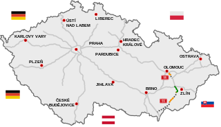
D55 motorway, formerly R55 expressway is a motorway in the Czech Republic. The D55 will connect Olomouc and bypass Přerov, Hulín and Otrokovice, where the regional town of Zlín will also be connected via the D49. Through the sections around Uherské Hradiště, the D55 will be connected to the D2 near Břeclav in the future.

<span class="mw-page-title-main">D49 motorway (Czech Republic)</span> Czech motorway

D49 motorway, formerly Expressway R49 is an motorway under construction in the Czech Republic. When completed, it will connect D1 highway to the Slovakia's D1 highway via the R6 expressway. It is supposed to replace the planned route of the D1 highway to Slovakia, which original direction to Púchov (Slovakia) was diverted and now leads to Ostrava.

<span class="mw-page-title-main">Prague-West District</span> District in the Czech Republic

Prague-West District is a district in the Central Bohemian Region of the Czech Republic. Its capital is Prague. The most populated town of the district is Jesenice.

<span class="mw-page-title-main">Highways in the Czech Republic</span> Overview of highways in the Czech Republic

Highways in the Czech Republic are managed by the state-owned Directorate of Highways and Motorways of the Czech Republic – ŘSD ČR. The ŘSD currently manages and maintains 1,501 km of motorways (dálnice) and the national speed limit is 130 km/h with an expectation that limit will be increased for some sections to 150 km/h (93 mph). The length of the motorway network is planned to be expanded to 2,000 km by 2030.

<span class="mw-page-title-main">Highways in Slovakia</span>

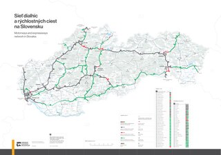
Highways in Slovakia are divided into motorways and expressways.

<span class="mw-page-title-main">Line D (Prague Metro)</span> Metro line in Czechia

Line D is an under construction line of the Prague Metro, which will serve Prague 4 and Prague 12 in the south of the Czech capital. Construction began on the first part of the line in 2022.

<span class="mw-page-title-main">Písnice</span> Cadastral Area of Prague in Czech Republic

Písnice is a borough of the city of Prague, and a cadastral subdivision of Libuš and the municipal district of Prague 12. It was an independent municipality until its amalgamation into Prague in 1974. There are 42 streets and 496 addresses registered, and a population of over 4,000.

<span class="mw-page-title-main">Smíchov City</span> Development project in Prague

Smíchov City (2020–2032) is a construction project in Prague, Czech Republic. It is planned on the site of one of the largest brownfields in Prague – the former freight railway station in Smíchov, which is almost 20 hectares in area. This entire new neighborhood, which has been in preparation for the past 15 years, will be the largest single project in the history of the Czech Republic and will become a symbol of the transformation of Prague in the 21st century. The project's investor is the Sekyra Group. It is the largest urban neighborhood to be created in Prague since Vinohrady.

<span class="mw-page-title-main">Flag of Prague</span> Municipal flag in the Czech Republic

The flag of Prague, officially the flag of the capital city of Prague is one of the symbols of Prague, alongside the coat of arms of Prague.

References

  1. "Pražský okruh bude hotov nejdříve v roce 2029. Na severu Prahy chtějí tunel" (in Czech). Denik.cz. 2018-03-21. Retrieved 2025-01-30.
  2. Korf, Jaroslav; Hejl, Petr. "Stručná rekapitulace a vyjádření k vývoji územních plánu rajónu Pražské středočeské aglomerace (VÚC), směrného územního plánu Prahy (SÚPN) a územního plánu Prahy (ÚPN) z pohledu trasování dálničního okruhu na SZ Prahy" (PDF) (in Czech).
  3. "Řidiči objedou Prahu po nové dálnici poprvé 20. září" (in Czech). iDnes.cz. 2010-06-28. Retrieved 2024-10-30.
  4. "Prague Ring Road to Be Extended by 12 Kilometres". Prague Daily News. 2024-11-24. Retrieved 2025-01-31.
  5. "D0 511: Běchovice–D1" (PDF) (in Czech). ŘSD. Retrieved 2024-10-30.
  6. SŮRA, Jan (2021-02-04). "Milionové ztráty za každý den bez Pražského okruhu - Stavbu má urychlit výjimka". Pražský deník. Retrieved 2024-10-30.
  7. "Soud opět zastavil projekt stavby severní části obchvatu Prahy" (in Czech). iDNES.cz. 2014-04-16. Retrieved 2025-01-31.

Content in this edit is translated from the existing Czech Wikipedia article at cs:Dálnice D0; see its history for attribution.

49°58′46″N14°28′49″E / 49.97944°N 14.48028°E / 49.97944; 14.48028