Last updated • 3 min readFrom Wikipedia, The Free Encyclopedia
Motorway ring road in Germany
This article is about the Cologne Outer Ring. For the Cologne Inner Ring, see Cologne Ring.
You can help expand this article with text translated from the corresponding article in German. (January 2025)Click [show] for important translation instructions.
Machine translation, like DeepL or Google Translate, is a useful starting point for translations, but translators must revise errors as necessary and confirm that the translation is accurate, rather than simply copy-pasting machine-translated text into the English Wikipedia.
Do not translate text that appears unreliable or low-quality. If possible, verify the text with references provided in the foreign-language article.
You must provide copyright attribution in the edit summary accompanying your translation by providing an interlanguage link to the source of your translation. A model attribution edit summary is Content in this edit is translated from the existing German Wikipedia article at [[:de:Kölner Autobahnring]]; see its history for attribution.
You may also add the template {{Translated|de|Kölner Autobahnring}} to the talk page.
The beltway was constructed in a clockwise fashion beginning at Leverkusen. In 1936 the section between Leverkusen and Cologne-Mülheim was built as a component of the Autobahn Oberhausen-Wiesbaden and in 1937 the section to Siegburg was finished. Thus today's Ostring (East-Ring) was drivable at that time. In 1941, the Rodenkirchener Autobahnbrücke was completed and the connection between the A 3 and the Autobahn to Bonn (today A 555) was established.
From 1957 to 1960 the Autobahn Cologne-Aachen was finished and the section from Kreuz Köln-Süd to the later Kreuz Köln-West was put into service in 1958. Construction of a second Autobahn-bridge across the Rhine in the north of Cologne began in 1961. At its completion, the beltway could be used along its entire length.
In 1971, the A 1 was extended to the south beyond the Köln-West interchange and in 1974 the A 4 was connected to the A 3 from the east at the Köln-Ost interchange. Since then, the section between interchanges Kreuz Köln-Ost and Dreieck Heumar consists of two Autobahns, the A 3 and the A 4.
Current state
Traffic volume on the Cologne Beltway has been increasing continuously since the 1950s. Almost all sections, with the exception of a short stretch on the A1 between Kreuz Köln-West and 1km north of Köln-Lövenich (Expansion in progress there, estimated completion December 2013), have since been expanded to three lanes in each direction, but since more than 180,000 cars use at least part of the Autobahnring every day, traffic jams are a frequent occurrence. The section between the interchanges Kreuz Köln-Ost and Dreieck Heumar was expanded to four lanes in each direction in 2005, a first for North Rhine-Westphalia. In 2008 the section with four lanes in each direction has been extended to the interchange Köln-Dellbrück. Currently widening work is going on between Köln-Dellbrück and Köln-Mülheim. It was scheduled to be complete in autumn 2012. The A1 has mostly a speed limit of 100km/h. It has recently been raised to 120km/h northbound between Köln-Lövenich and Köln-Bocklemünd as well as between Kreuz Köln-Nord and Köln-Niehl. On the A4 the speed limit is 120km/h. On the A3 there is a variable speed limit up to a maximum of 120km/h.
In preparation for the 2006 FIFA World Cup the A 3 was outfitted with a traffic management system which is able to route traffic around congestion and construction sites.
"Second Beltway"
In the 1970s, a second beltway around Cologne was considered, incorporating existing Autobahns, instead of expanding the first one to more lanes. An expansion of the old beltway was considered as too expensive because of the large number of bridges. It was planned to incorporate some of Cologne's other Autobahns into this second Autobahnring. These plans were however never implemented.
The Autobahn is the federal controlled-access highway system in Germany. The official term is Bundesautobahn, which translates as 'federal motorway'. The literal meaning of the word Bundesautobahn is 'Federal Auto(mobile) Track'.
Bundesautobahn 1 is an autobahn in Germany. It runs from Heiligenhafen in Schleswig-Holstein to Saarbrücken, a distance of 749 km (465 mi), but is incomplete between Cologne and Trier. B 207 continues north from Heiligenhafen to Puttgarden, at the end of the island of Fehmarn, with a ferry to Rødby, Denmark.
Bundesautobahn 7 is the longest German Autobahn and the longest national motorway in Europe at 963 km. It bisects the country almost evenly between east and west. In the north, it starts at the border with Denmark as an extension of the Danish part of E45. In the south, the autobahn ends at the Austrian border. This final gap was closed in September 2009.
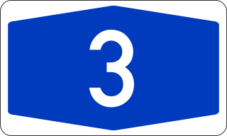
Bundesautobahn 3 is an autobahn in Germany running from the Germany-Netherlands border near Wesel in the northwest to the Germany-Austria border near Passau.
Bundesautobahn 555 is an autobahn connecting the cities of Cologne and Bonn. It was constructed between 1929 and 1932, and opened to traffic on 6 August 1932.
Bundesautobahn 61 is an autobahn in Germany that connects the border to the Netherlands near Venlo in the northwest to the interchange with A 6 near Hockenheim. In 1965, this required a redesign of the Hockenheimring.
Bundesautobahn 4 is an autobahn in two discontinuous segments that crosses Germany in a west–east direction. The western segment has a length of 156 km (97 mi), while the part in the east is 429 km (267 mi) long.
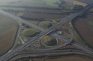
The Kamener Kreuz was formerly a full cloverleaf interchange near Dortmund in North Rhine-Westphalia Germany where the Autobahnen A1 and A2 meet. It lies between the towns of Kamen and Bergkamen in the west and the city of Hamm and the municipality Bönen in the east. The Kamener Kreuz, opened in 1937, was the second interchange between two Reichsautobahnen, the first one being the Schkeuditzer Kreuz. It is used by 160,000 vehicles per day.
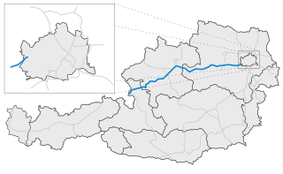
The West Autobahn (A1) was the first motorway (Autobahn) to be built in Austria, originating from plans drawn up for the so-called Reichsautobahn system. Completed in 1967, today it runs from the outskirts of Vienna via Linz to Salzburg, where it joins the German Bundesautobahn 8 at the Walserberg border crossing.
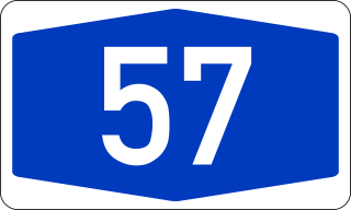
Bundesautobahn 57 is a German Autobahn that begins at the Dutch-German border near Goch and ends in Köln. It runs parallel to the Rhine River. Neuss and Krefeld are the biggest cities on this motorway. The A 57 is a continuation of the Dutch A77. Because of its high economic importance, its nickname is "Trans-Niederrhein-Magistrale". Most of it is two lanes each way and prone to traffic jams during rush hour.
The Cologne–Frankfurt high-speed rail line is a 180-kilometre-long (110 mi) high-speed line in Germany, connecting the cities of Cologne and Frankfurt. Its route follows the Bundesautobahn 3 for the greater part, and currently the travel time is about 62 minutes. The line's grades of up to four percent require trains with a high power-to-weight ratio which is currently only met by third-generation and fourth-generation Intercity-Express trains, with the latter operating at reduced speeds. It was constructed between 1995 and 2002 at a total cost of six billion Euro according to Deutsche Bahn.
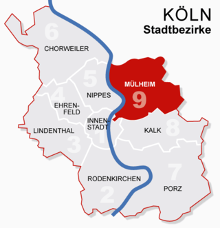
Mülheim is a borough (Stadtbezirk) of Cologne in Germany and a formerly independent town. Mülheim is located on the right bank of the Rhine opposite the old town of Cologne.
Bundesautobahn 10 is an orbital motorway around the German capital city of Berlin. Colloquially called Berliner Ring , it is predominantly located in the state of Brandenburg, with a short stretch of 5 km in Berlin itself. It should not be confused with the Berliner Stadtring around Berlin's inner city.
Bundesautobahn 9 is an autobahn in Germany, connecting Berlin and Munich via Leipzig and Nuremberg. It is the fifth longest autobahn spanning 529 km (328.71 mi).
Bundesautobahn 45 is an autobahn in Germany, connecting Dortmund in the west with Aschaffenburg in the southwest. It is colloquially known as the Sauerlandlinie as it runs through the hilly, rural Sauerland region between Hagen and Siegen. The A45 has many bridges to cross valleys, the highest of which is the Sichter Valley bridge between Lüdenscheid and Meinerzhagen at 530 metres above mean sea level. It is mostly two lanes each way with frequent climbing lanes between Dortmund-Hafen and the Gambacher Kreuz intersection. In March 2013 30 people were injured in a pile-up on the A45.
Bundesautobahn 60 is an autobahn in Germany. During its entire course it forms a part of the E 42.
This article covers transportation in and around the city of Cologne, Germany.
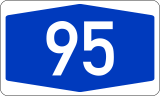
Bundesautobahn 95 is a motorway in southern Germany, supposed to connect Munich with Garmisch-Partenkirchen.
The Kreuz Kaiserberg is a spaghetti junction in the Metropolitan region Rhein-Ruhr in the German state of North Rhine-Westphalia.
This page is based on this Wikipedia article Text is available under the CC BY-SA 4.0 license; additional terms may apply. Images, videos and audio are available under their respective licenses.