| This article is part of a series on the |
| City of Cologne |
|---|
 |
This article covers transportation in and around the city of Cologne, Germany.
| This article is part of a series on the |
| City of Cologne |
|---|
| |
This article covers transportation in and around the city of Cologne, Germany.

The city of Cologne possesses one of the most comprehensive urban ring road systems. The beltways were laid out during the end of the 19th and in the early 20th centuries and today are still being complemented and extended. Their development originated in the work of architects and urban designers such as Karl Henrici, Josef Stübben and Fritz Schumacher as well as former Cologne mayors Hermann Heinrich Becker and Konrad Adenauer. They include the Cologne Ring, Innere Kanalstraße, the Cologne Belt, Militärringstraße and the Cologne Beltway.
Arterial roads east of the Rhine all start in Deutz. Deutz is a neighborhood in Innenstadt. They include Pfälzischer, Bergischer and Clevischer Ring (extending into Düsseldorfer Straße), Stadtautobahn (extending into BAB 4) and Deutz-Kalker-Straße (extending into Kalker Hauptstraße and Olpener Straße).
Arterial roads west of the Rhine mostly start at the Cologne Inner Ring. They include Bonner Straße (extending into BAB 555), Vorgebirgstraße, Luxemburger Straße, Dürener Straße, Aachener Straße, Venloer Straße and Neusser Straße (extending into Neusser Landstraße).
Freeway construction became a major issue in Cologne starting in the 1920s under the leadership of Mayor Konrad Adenauer. The first German limited access highway ( autobahn ) was opened in 1932 between Cologne and Bonn. Today, this is A 555. In 1965 Cologne became the first German city to be fully encircled by a beltway. Shortly after the Second World War reconstruction plans by, among others, Rudolf Schwarz called for a downtown bypass freeway (the "Stadtautobahn" (in German)) as a centerpiece of rebuilding the city. These schemes were only partially executed though, due to opposition by environmental groups. The completed section became Bundesstraße (Federal Road) B 55a which begins at the Zoobrücke (Zoo Bridge) and meets with A 4 and A 3 autobahns at the Cologne East interchange. Nevertheless, it is referred to as Stadtautobahn by most locals. However another project anticipated even before the war by planner and architect Fritz Schumacher in the 1920s has fared better. The Nord-Süd-Fahrt (North-South-Drive), a four/six lane downtown expressway, was completed in 1972.
In 2005 the first stretch of A 3 between the Cologne East and Heumar interchanges, which forms part of the eastern section of the beltway, was widened to 8 lanes. Work continues on widening the remaining portions of the A 3 between the Cologne East and Leverkusen interchanges. Meanwhile, in context with the pending replacement of the Rhine bridge at Leverkusen, the state highway administration favors widening the adjacent sections of the Cologne Beltway to 10 and - in a small section south of the interchange Leverkusen - even 12 lanes. [1]


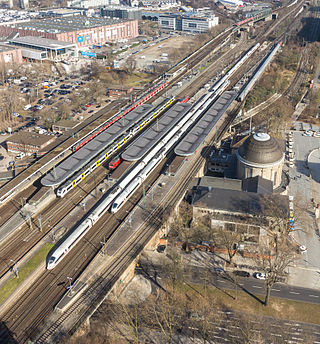
Cologne has Deutsche Bahn Service with InterCity and ICE-trains stopping at Köln Hauptbahnhof (Cologne Central Station), Köln Messe/Deutz and Flughafen Köln/Bonn. The first railway was opened in 1839 by the defunct Rheinische Eisenbahngesellschaft (Rhenanian Railway Company) on the line from Cologne via Aachen to Belgium, today's Cologne–Aachen high-speed railway. A Central Station was erected in 1859 to connect the lines of five different railway companies, which mostly had different stations before.
Cologne also has Thalys train service to connect to cities in different countries such as Amsterdam, Brussels, and Paris.
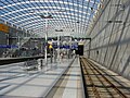
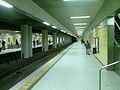
The Cologne Stadtbahn operates an extensive light rail and rapid transit system (partially underground) serving Cologne and some neighboring cities. Its name derives from the German term for light rail, Stadtbahn. It is operated by the Kölner Verkehrs-Betriebe (KVB) (Cologne Transit Company) and is part of the Rhine-Sieg Transit Association. The rail system stretches across 192 kilometers with 11 lines. Two lines (16 and 18) link the system to the neighboring transport system of Bonn. The Cologne Stadtbahn is not a true subway system, even though a large part of the system operates underground, especially in the downtown area. Instead it is a rapid tram system, each line crosses at least one street at street level without absolute right of way.
The Cologne Stadtbahn traces its beginnings to the year 1877, when the first horse-drawn tram line was opened. The first stretch of an underground route network was completed in 1968. Underground construction in the downtown Cologne area is often obstructed by the fact that archeologists in Cologne, one of Germany's oldest cities, have legal rights to dig in all future building sites within the medieval city limits before all heavy construction machinery. Currently the average cruising speed is 26.6 kilometers per hour (2006).
The Rhine-Ruhr S-Bahn has 5 lines which cross Cologne. The S13/S19 runs 24/7 between Cologne Hbf and Cologne/Bonn Flaughafen.


| | This section needs expansion. You can help by adding to it. (April 2010) |
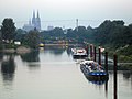
Cologne Ports (HGK) is one of the largest operators for inland ports in Germany. [2] Ports include Deutz, Godorf, Mülheim and Niehl I and II.


The name of Cologne's international Airport ( IATA : CGN, ICAO : EDDK) is Konrad-Adenauer-Flughafen. It is shared with the neighbouring city of Bonn (Cologne/Bonn Region). It's the sixth largest airport in Germany while in terms of cargo flights it is No. 2. In 2007 the number of passengers climbed to about 10.5 million. The current Airport was opened to civilian traffic in 1951 by the British armed forces, which used the former airport in Cologne Ossendorf increasingly for their own military purposes. A completely new terminal was built in 1970, supplementing the hitherto makeshift buildings. This building was adjoined by an extension in 2000, called Terminal 2, which has been planned by German-American architect Helmut Jahn. Terminal 1, which the building from 1970 is called since then, had already acquired preservation status for its easily recognizable brutalist concrete architecture.


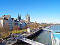
Cologne is the largest city of the German western state of North Rhine-Westphalia (NRW) and the fourth-most populous city of Germany with nearly 1.1 million inhabitants in the city proper and over 3.1 million people in the urban region. Centered on the left (west) bank of the Rhine, Cologne is about 35 km (22 mi) southeast of NRW's state capital Düsseldorf and 25 km (16 mi) northwest of Bonn, the former capital of West Germany.

North Rhine-Westphalia, commonly shortened to NRW, is a state (Land) in Western Germany. With more than 18 million inhabitants, it is the most populous state in Germany. Apart from the city-states, it is also the most densely populated state in Germany. Covering an area of 34,084 square kilometres (13,160 sq mi), it is the fourth-largest German state by size.

Koelnmesse GmbH is an international trade fair and exhibition center located in Cologne, North Rhine-Westphalia, Germany. With around 80 trade fairs and over 2,000 conferences annually, Koelnmesse is one of the country's largest trade fair organisers and with 284,000 m² exhibition floor area the third largest by area.

Köln Hauptbahnhof or Cologne Central Station is a railway station in Cologne, Germany. The station is an important local, national and international transport hub, with many ICE, Thalys and Intercity trains calling there, as well as regional Regional-Express, RegionalBahn and local S-Bahn trains. EuroNight and Nightjet night services also call at the station. It has frequent connections to Frankfurt by way of the Cologne–Frankfurt high-speed rail line, which starts in southern Cologne. On an average day, about 280,000 travellers frequent the station, making it the fifth busiest station in Germany.
Köln Messe/Deutz station is an important railway junction for long-distance rail and local services in the Cologne district of Deutz in the German state of North Rhine-Westphalia. It is situated close to the eastern bank of the Rhine and connected via the Hohenzollern Bridge to Köln Hauptbahnhof, the city's main station, which is just a few hundred metres away. The Cologne Trade Fair grounds are directly north of the station, hence the Messe in the station's name. The Stadtbahn station of Deutz/Messe is nearby and connected by a pedestrian tunnel.

The Cologne Stadtbahn is a light rail system in the German city of Cologne, including several surrounding cities of the Cologne Bonn Region. The term Stadtbahn denotes a system that encompasses elements of trams as well as an underground railway network (U-Bahn) and interurban rail, even including three lines that are licensed as heavy rail and used by freight trains as well as Stadtbahn vehicles. Two of these lines connect the Cologne Stadtbahn to the Bonn Stadtbahn. These lines are jointly operated by both cities' transport authorities, resulting in both systems and the lines connecting them sometimes collectively referred to as Stadtbahn Rhein-Sieg.

Porz is a borough or Stadtbezirk of Cologne, Germany. It is situated on the east side of the Rhine in the south-east of the city. Porz is the largest borough of Cologne by area at 78.92 km2 and has 113,500 inhabitants.
Line S 11 is a S-Bahn line operated by DB Regio on the Rhine-Ruhr S-Bahn network. It connects Düsseldorf Airport Terminal with Bergisch Gladbach, running via Düsseldorf Neuss, Dormagen and Cologne. Before 13 December 2009, the service operated from Wuppertal-Vohwinkel in peak time, sharing the Wuppertal-Düsseldorf run with the S8 trains. Normal operation, though, started at Düsseldorf-Wehrhahn. Since the introduction of the new 2010 Schedule the service starts at Düsseldorf Airport Terminal replacing the line S 7 to Düsseldorf Hbf. The former run to Wuppertal-Vohwinkel is now conducted by the S 68.

Siegburg/Bonn station, in the town of Siegburg, North Rhine-Westphalia, Germany, is on the Cologne–Frankfurt high-speed rail line and the Sieg Railway. It was rebuilt for the high-speed line and is connected to Bonn by the Siegburg line of the Bonn Stadtbahn. It is in the network area of the Verkehrsverbund Rhein-Sieg.
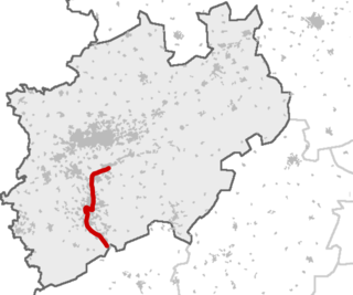
The Cologne Beltway is the collective term for the Autobahns encircling Cologne. It consists of the Bundesautobahn 1, the Bundesautobahn 3 and the Bundesautobahn 4. Segments of the beltway handle the highest traffic volume in Germany.

Cologne/Bonn Airport is a station at Cologne Bonn Airport in the German state of North Rhine-Westphalia. It was built as part of the Cologne–Frankfurt high-speed rail line and opened in June 2004 on an approximately 15 kilometre-long airport loop. It is served by Intercity-Express (ICE), Rhine-Ruhr S-Bahn and regional services.

The Cologne Ring is a semi-circular, some 6 km long urban boulevard in Innenstadt, Cologne and the city's busiest and most prominent street system. The Cologne Ring is a four lane street and part of Bundesstraße 9.

The Cologne Bonn Region is a metropolitan area in North Rhine-Westphalia (NRW), Germany, covering the cities of Cologne, Bonn and Leverkusen, as well as the districts of Rheinisch-Bergischer Kreis, Oberbergischer Kreis, Rhein-Erft-Kreis and Rhein-Sieg-Kreis. The region covers an area of 3,839 km² with 3.13 million inhabitants. The city centres of Cologne and Bonn are 24 kilometres apart as the crow flies. At the outer city limits, there are only 8 kilometres between Cologne-Libur and Bonn-Geislar.
The Gruiten–Cologne-Deutz railway is a major German railway. It is part of a major axis for long distance and regional rail services between Wuppertal and Cologne, and is served by Intercity Express, InterCity, Regional-Express and regionalbahn trains.

Köln West station is located in the northwestern edge of the Innenstadt of Cologne in the district of Neustadt-Nord in the German state of North Rhine-Westphalia. It is located on Venloer Straße (street). The station is a stop for regional services on the Cologne ring railway. It is also served by lines 3, 4 and 5 lines of the Cologne Stadtbahn, which run through the Hans-Böckler-Platz/Bf. West underground station. The surface station has two platform tracks on a 303-metre-long island platform and eight tracks without platforms, which are used by intensive freight traffic.

Köln-Mülheim is a railway station situated at Mülheim, Cologne in western Germany. It is served by several regional trains, the S6 and S11 lines of the Rhine-Ruhr S-Bahn and the 13 and 18 lines of Cologne Stadtbahn.

Köln Süd station is located in the southwestern edge of the Innenstadt of Cologne in the district of Neustadt-Süd in the German state of North Rhine-Westphalia. It is located between the streets of Luxemburger Straße and Zülpicher Straße. The station is a stop for regional services on the West Rhine Railway. The Cologne freight railway bypass branches off from the station over the South Bridge; it is also used as needed by passenger trains. The station has four platform tracks at two island platforms and two tracks without platforms, which are used by the intensive freight traffic. It is classified by Deutsche Bahn as a category 4 station.
The Rhein-Wupper-Bahn is a Regionalbahn service in the German state of North Rhine-Westphalia. It connects the cities of Wuppertal, Solingen, Leverkusen, Cologne and Bonn and it is operated by National Express.