List of streets in Cologne

Last updated

This is an overview of streets and roads in the city of Cologne . It includes a list of notable streets, for historic, transportation or other reasons and is to present an understanding of the city's road systems. The scope of this article does not cover the city's public squares.

Contents

Innenstadt streets

This is a list of some notable streets in Innenstadt, Cologne.

Streets and alleys in Altstadt

Entrance of Lintgasse, as seen from Alter Markt Alter-Markt-Koln-Eingang-Lintgasse.jpg
Entrance of Lintgasse, as seen from Alter Markt
House at corner of Zulpicher Strasse and Heinsbergstrasse Cologne 2012 001.jpg
House at corner of Zülpicher Straße and Heinsbergstraße
StreetLengthLandmarksnote
Am HofHaus Saaleck, Früh brewery
Am LeystapelSt. Maria in Lyskirchen
Breite Straße0,38 km Zeichen 239 - Sonderweg Fussganger, StVO 1992.svg pedestrian zone
Brückenstraße Zeichen 239 - Sonderweg Fussganger, StVO 1992.svg pedestrian zone
Cäcilienstraße St. Cäcilien, Museum Schnütgen
Ehrenstraße 0,37 km Vorschriftszeichen 10a.svg tempo 30 zone
Eigelstein Eigelsteintor Vorschriftszeichen 10a.svg tempo 30 zone
FilzengrabenHoly Trinity Church
Friesenstraße 0,32 km Vorschriftszeichen 10a.svg tempo 30 zone
Gereonstraße St. Gereon
Glockengasse 0,23 km 4711 House, Cologne Opera
Gürzenichstraße0,32 km Gürzenich Zeichen 239 - Sonderweg Fussganger, StVO 1992.svg pedestrian zone
Hahnenstraße0,48 kmHahnentor
Hohe Straße 0,68 km Stollwerck Passage Zeichen 239 - Sonderweg Fussganger, StVO 1992.svg pedestrian zone
StreetLengthLandmarksnote
Lintgasse 0,13 km Gaffel-Haus Zeichen 239 - Sonderweg Fussganger, StVO 1992.svg pedestrian zone
Kartäusergasse Cologne Charterhouse
Komödienstraße St. Andreas
Krebsgasse 0,27 km Vorschriftszeichen 10a.svg tempo 30 zone
MagnusstraßeRömerturm
MinoritenstraßeMinorites Church, Kolumba
Mittelstraße0,19 km St. Aposteln Vorschriftszeichen 10a.svg tempo 30 zone
Mühlenbach
RheingasseOverstolzenhaus
Schaafenstraße0,25 km
Schildergasse 0,50 km Antoniterkirche, Weltstadthaus Zeichen 239 - Sonderweg Fussganger, StVO 1992.svg pedestrian zone
Severinstraße 1,05 km Basilica of St. Severin, Severinstor
Ulrichgasse Ulrepforte
Zeughausstraße Zeughaus

Streets in Neustadt

StreetLengthLandmarksnote
Aachener Straße Millowitsch-Theater
Brüsseler Straße1,04 kmSt. Michael Vorschriftszeichen 10a.svg tempo 30 zone
Im Zollhafen0,71 km Rheinauhafen Zeichen 239 - Sonderweg Fussganger, StVO 1992.svg pedestrian zone
Maybachstraße MediaPark Vorschriftszeichen 10a.svg tempo 30 zone
Moltkestraße0,67 kmStadtgarten
Neusser Straße St. Agnes
StreetLengthLandmarksnote
Roonstraße0,80 km Roonstrasse Synagogue
Teutoburger Straße University of Applied Sciences
Venloer Straße Friesenplatz
Volksgartenstraße0,74 kmVolksgarten, Lutherkirche
Weißenburgstraße0,55 kmSt. Agnes, Oberlandesgericht Vorschriftszeichen 10a.svg tempo 30 zone
Zülpicher Straße Sacred Heart Church

Streets in Deutz

StreetLengthLandmarksnote
Deutzer Freiheit0,45 kmSt. Heribert Zeichen 239 - Sonderweg Fussganger, StVO 1992.svg pedestrian zone
Gotenring0,68 km Severin Bridge
Kennedy-Ufer Old St. Heribert Vorschriftszeichen 10a.svg tempo 30 zone
Siegburger StraßeDeutzer Hafen

Principal ring roads

The city of Cologne possesses one of the most comprehensive urban ring road systems. The beltways were laid out during the end of the 19th and the early 20th century and today are still being complemented and extended. Their development originated in the work of architects and urban designers such as Karl Henrici, Josef Stübben and Fritz Schumacher as well as former Cologne mayors Hermann Heinrich Becker and Konrad Adenauer.

Cologne Ring

Hohenzollernring on the Cologne Ring Hohenzollernring-Koln-027-2.JPG
Hohenzollernring on the Cologne Ring

The Cologne Ring (German : Kölner Ring or plural Kölner Ringe) is a semi-circular, some 6 km long urban boulevard in Innenstadt, Cologne and the city's busiest and most prominent street system. The Cologne Ring is a four-lane street and part of Bundesstraße 9.

The ring sections between Barbarossaplatz and Ebertplatz are some of the busiest streets in Cologne.

RoadsLengthAverage distance to Cologne Cathedral Note
Ubierring, Chlodwigplatz, Karolingerring, Sachsenring, Salierring, Barbarossaplatz, Hohenstaufenring, Habsburgerring, Rudolfplatz, Hohenzollernring, Kaiser-Wilhelm-Ring, Hansaring, Ebertplatz, Theodor-Heuss-Ring6.0 km1.6 km Bundesstrasse 9 number.svg Bundesstraße 9

Innere Kanalstraße

Innere Kanalstraße is part of a ring road system, which spans from Vorgebirgstraße in the south-west to Zoobrücke in the north-east. Innere Kanalstraße and Universitätsstraße are the longest of these streets and follow the outside outline of the Cologne Green Belt [1] (German: Kölner Grüngürtel). They therefore encircle the district of Innenstadt to the west and north-west. These are mostly six-lane roads and follow the Inner Ring almost concentrically. Kanal- and Universitätsstraße are a major relief of traffic load on the Inner Ring. Landmarks on Universitätsstraße are the University, after which the street is named, and the Aachener Weiher with the Museum of East Asian Art. Landmarks on Innere Kanalstraße are the Colonius telecommunication tower and the Herkules tower.

RoadsLengthAverage distance to Cologne Cathedral Note
Am Vorgebirgstor, Pohligstraße, Weißhausstraße, Universitätsstraße, Innere Kanalstraße, Zoobrücke10 km2.0 km Bundesstrasse 55a number.svg Bundesstraße 55a (partially)

Cologne Belt

Sulzgurtel on the Cologne Belt Koln- Station- Sulzgurtel-008.JPG
Sülzgürtel on the Cologne Belt

The Cologne Belt (German: Kölner Gürtel) is a system of ring roads which runs through the Left-Rhenish districts of Cologne. The sections of the Cologne Belt are mostly defined by the large arterial roads running perpendicular to them and are named after the districts and city parts they pass through. The Cologne Belt was set up in the early 20th century and is somewhat concentric to Kanal- and Universitätsstraße and the Cologne Inner Ring.

RoadsLengthaverage distance to Cologne Cathedral note
Bayenthalgürtel, Raderberggürtel, Raderthalgürtel, Zollstockgürtel, Klettenbergürtel, Sülzgürtel, Lindenthalgürtel, Stadtwaldgürtel, Melatengürtel, Ehrenfeldgürtel, Parkgürtel, Mauenheimer Gürtel, Niehler Gürtel15 km3.5 km

Militärringstraße

Only a minor street today, the Militärringstraße once had significance for the fortifications of Cologne during the 19th and early 20th century. The Militärring once was a true ring, encircling the entire city at a length of some 40 km (25 mi).

RoadsLengthAverage distance to Cologne Cathedral Note
Militäringstraße25 km [2] 4.9 to 7.7 km

Cologne Beltway

BAB 1 on the Cologne Beltway Koln-Lindweiler, A1.jpg
BAB 1 on the Cologne Beltway

The Cologne Beltway (German: Kölner Autobahnring) is the generic term for the Autobahns encircling Cologne. It consists of the Bundesautobahn 3, the Bundesautobahn 4 and the Bundesautobahn 1. With an average of 160,000 cars per day on the BAB 3 and 100,000 on A4 and A1, the beltway handles one of the highest traffic volumes in Germany. [3]

The beltway crosses the Rhine at Leverkusen Bridge in the north and Cologne Rodenkirchen Bridge in the south. The Autobahns on the beltway cross Bundesautobahn 559, Bundesautobahn 555 and Bundesautobahn 57. The Bundesautobahn 59 is tied to the beltway at the interchange Leverkusen-West in the north and to Dreieck Heumar in the south. Cologne/Bonn Airport lies on the Bundesautobahn 59.

RoadsLengthAverage distance to Cologne Cathedral Note
Bundesautobahn 3, Bundesautobahn 4, Bundesautobahn 1 50 km5.0 to 12.0 km

Principal arterial roads

High and freeways in Cologne Koelner Ring.png
High and freeways in Cologne
Kalker Hauptsrasse Kalker-HS-07-04-07.jpg
Kalker Hauptsraße
Luxemburger Strasse Luxemburger Str. Koeln a5.jpg
Luxemburger Straße

In the following a list of arterial roads, starting clockwise in the North-East. The names of some roads indicate the city or direction, they lead towards.

Right-Rhenish arterial roads all start in Deutz. Deutz is a city part of Innenstadt. Left-Rhenish arterial roads mostly start at the Cologne Ring. Of the major arterial roads, only Dürener Straße and the BAB 57 start on Universitätsstraße and Innere Kanalstraße respectively. Konrad-Adenauer-Ufer is a river embankment road, leading further into the center up to Hohenzollern Bridge.

Right-Rhenish arterial roads

RoadLength Districts note
Pfälzischer, Bergischer and Clevischer Ring (extend into Düsseldorfer Straße) Deutz, Mülheim Bundesstrasse 8 number.svg B 8 Bundesstraße 8
Stadtautobahn (extends into BAB 4)3,55 + 4,51 kmwithin city limitsDeutz, Mülheim, Kalk Bundesstrasse 55a number.svg B 55a Bundesstraße 55a
Deutz-Kalker-Straße (extends into Kalker Hauptstraße and Olpener Straße)1,06 + 1,63 + 6,06 kmDeutz, KalkBundesstrasse 55 number.svg B 55 Bundesstraße 55
Östliche Zubringerstraße (part of BAB 559)8,40 kmDeutz, Porz Bundesautobahn 559 number.svg A 559 Bundesautobahn 559
Siegburger Straße (extends into Kölner Straße and Hauptstraße)3,84 + 3,76 + 4,43 kmDeutz, Porz

Left-Rhenish arterial roads

RoadLength Districts note
Agrippinaufer and Gustav-Heinemann-Ufer Innenstadt, Rodenkirchen Bundesstrasse 9 number.svg B 9 Bundesstraße 9
Bonner Straße (extends into BAB 555)3,18 + 5,93 kmwithin city limitsInnenstadt, RodenkirchenBundesautobahn 555 number.svg A 555 Bundesautobahn 555
Vorgebirgstraße2,62 kmRodenkirchen
Luxemburger Straße4,21 kmwithin city limitsInnenstadt, Lindenthal Bundesstrasse 265 number.svg B 265 Bundesstraße 265
Dürener Straße6,08 kmLindenthalBundesstrasse 264 number.svg B 264 Bundesstraße 264
Aachener Straße8,51 kmwithin city limitsInnenstadt, LindenthalBundesstrasse 55 number.svg B 55 Bundesstraße 55
Venloer Straße8,48 kmwithin city limitsInnenstadt, Ehrenfeld Bundesstrasse 59 number.svg B 59 Bundesstraße 59
Kreisstraße 4 (extends into BAB 57)1,47 + 14,71 kmwithin city limitsEhrenfeld, Nippes, Chorweiler Bundesautobahn 57 number.svg A 57 Bundesautobahn 57
Neusser Straße (extends into Neusser Landstraße)Innenstadt, Nippes, ChorweilerBundesstrasse 9 number.svg B 9 Bundesstraße 9
Riehler StraßeInnenstadt, Nippes
Konrad-Adenauer-Ufer1,78 kmInnenstadtBundesstrasse 51 number.svg B 51 Bundesstraße 51

See also

Related Research Articles

<span class="mw-page-title-main">Cologne</span> Largest city in North Rhine-Westphalia, Germany

Cologne is the largest city of the German state of North Rhine-Westphalia and the fourth-most populous city of Germany with nearly 1.1 million inhabitants in the city proper and over 3.1 million people in the Cologne Bonn urban region. Cologne is also part of the Rhine-Ruhr metropolitan region, the second biggest metropolitan region by GDP in the European Union. Centered on the left (west) bank of the Rhine, Cologne is located on the River Rhine, about 35 km (22 mi) southeast of the North Rhine-Westphalia state capital Düsseldorf and 25 km (16 mi) northwest of Bonn, the former capital of West Germany.

<span class="mw-page-title-main">Ring road</span> Type of road encircling a settlement

A ring road is a road or a series of connected roads encircling a town, city or country. The most common purpose of a ring road is to assist in reducing traffic volumes in the urban centre, such as by offering an alternate route around the city for drivers who do not need to stop in the city core. Ring roads can also serve to connect suburbs to each other, allowing efficient travel between them.

<span class="mw-page-title-main">Bundesautobahn 555</span> Federal motorway in Germany

Bundesautobahn 555 is an autobahn connecting the cities of Cologne and Bonn. It was constructed between 1929 and 1932, and opened to traffic on 6 August 1932.

<span class="mw-page-title-main">Bundesautobahn 4</span> Federal motorway in Germany

Bundesautobahn 4 is an autobahn in two discontinuous segments that crosses Germany in a west–east direction. The western segment has a length of 156 km (97 mi), while the part in the east is 429 km (267 mi) long.

<span class="mw-page-title-main">Bundesautobahn 5</span> German motorway

Bundesautobahn 5 is a 445 km (277 mi) long Autobahn in Germany. Its northern end is the Hattenbach triangle intersection. The southern end is at the Swiss border near Basel. It runs through the German states of Hessen and Baden-Württemberg and connects on its southern ending to the Swiss A 2.

<span class="mw-page-title-main">Mülheim, Cologne</span> Borough of Cologne in North Rhine-Westphalia, Germany

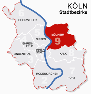
Mülheim is a borough (Stadtbezirk) of Cologne in Germany and a formerly independent town. Mülheim is located on the right bank of the Rhine opposite the old town of Cologne.

<span class="mw-page-title-main">Bundesautobahn 10</span> Federal motorway in Germany

Bundesautobahn 10 is an orbital motorway around the German capital city of Berlin. Colloquially called Berliner Ring , it is predominantly located in the state of Brandenburg, with a short stretch of 5 km in Berlin itself. It should not be confused with the Berliner Stadtring around Berlin's inner city.

<span class="mw-page-title-main">Bundesautobahn 999</span> Unbuilt federal motorway in Germany

Bundesautobahn 999 was the designated number for the Mittlerer Ring in Munich, Germany, a projected second ring road around the inner city districts to accompany the Münchner Ring (Bundesautobahn 99). The project to construct the Mittlerer Ring as an autobahn was not carried out, instead the Bundesstraße 2R now covers most of the planned A 999 trajectory.

<span class="mw-page-title-main">Bundesautobahn 115</span> Federal motorway in Germany

Bundesautobahn 115 is an autobahn in Berlin, Germany. It connects the Berliner Stadtring with the Berliner Ring, using parts of the old AVUS race track. AVUS was opened in 1921 as Germany's first limited access road. After World War II, the A 115 served an important function as a transit road between West Berlin and West Germany. In 1969, a small part of the autobahn was moved eastwards by GDR authorities so that the Checkpoint Bravo border crossing at Dreilinden would be fully on West Berlin territory.

This article covers transportation in and around the city of Cologne, Germany.

<span class="mw-page-title-main">Porz</span> Borough of Cologne in North Rhine-Westphalia, Germany

Porz is a borough or Stadtbezirk of Cologne, Germany. It is situated on the east side of the Rhine in the south-east of the city. Porz is the largest borough of Cologne by area at 78.92 km2 and has 113,500 inhabitants.

The Cologne Beltway is the collective term for the Autobahns encircling Cologne. It consists of the Bundesautobahn 1, the Bundesautobahn 3 and the Bundesautobahn 4. Segments of the beltway handle the highest traffic volume in Germany.

<span class="mw-page-title-main">Cologne Ring</span> Urban boulevard in Innenstadt, Cologne

The Cologne Ring is a semi-circular, some 6 km long urban boulevard in Innenstadt, Cologne and the city's busiest and most prominent street system. The Cologne Ring is a four lane street and part of Bundesstraße 9.

<span class="mw-page-title-main">Kalk, Cologne</span> Borough of Cologne in North Rhine-Westphalia, Germany

Kalk is the Eighth borough or Stadtbezirk of Cologne, Germany. Kalk was merged into the city of Cologne in 1910, the borough was formed in 1975.

<span class="mw-page-title-main">Ehrenfeld, Cologne</span> Borough of Cologne in North Rhine-Westphalia, Germany

Ehrenfeld is a borough (Stadtbezirk) of the City of Cologne in Germany. It includes the seven quarters Bickendorf, Bocklemünd, Mengenich, Ehrenfeld, Neuehrenfeld, Ossendorf and Vogelsang. It has about 109,500 inhabitants and covers an area of 23.98 square kilometres. The district borders with the Cologne districts of Chorweiler to the North, Nippes and Innenstadt to the East and Lindenthal to the South-West.

<span class="mw-page-title-main">Chorweiler</span> Borough of Cologne in North Rhine-Westphalia, Germany

Chorweiler is the sixth borough (Stadtbezirk) of Cologne, Germany. Large portion of the borough of Chorweiler were incorporated into the city of Cologne in 1922, the borough of Chorweiler was created in the 1970s. The borough has the lowest population density in Cologne and many areas are very rural.

<span class="mw-page-title-main">Nippes, Cologne</span> Borough of Cologne in North Rhine-Westphalia, Germany

Nippes is the fifth borough of Cologne, Germany. Nippes was incorporated into the city of Cologne in 1888 and the district was created in 1975. A large Ford Europe production plant is located in Niehl, the north-eastern part of the district.

<span class="mw-page-title-main">Innenstadt, Cologne</span> Borough of Cologne in North Rhine-Westphalia, Germany

Innenstadt is the central borough of the City of Cologne in Germany.

<span class="mw-page-title-main">Bundesautobahn 559</span> Federal motorway in Germany

Bundesautobahn 559 is an autobahn in Germany.

<span class="mw-page-title-main">Heumarkt station</span> Railway station in Cologne, Germany

Heumarkt station is a Stadtbahn interchange station in the historic Altstadt of Cologne, Western Germany. The station is an important hub between (low-floor) East-West and (high-floor) North-South connections.

References

  1. cologne-tourism.com/green-belt
  2. radregionrheinland.de
  3. Extension of the Cologne Ring Road Archived 2011-05-17 at the Wayback Machine

Bibliography