Districts of Cologne

Last updated

Since the last administrative reform in 1975, the City of Cologne is made up of nine Stadtbezirke and 86 Stadtteile. Stadtbezirk literally translates as city district, which are further subdivided into Stadtteile (city parts). The Stadtteile of Cologne's old and new town (Alt- and Neustadt) further consist of quarters, known as "Veedel" in both Kölsch and most often, the Rhinelandic regiolect, as well.

Contents

City districts are differentiated of being links- or rechtsrheinischleft or right of the Rhine , with the old town being left of the Rhine, as are 230,25 km2 (56.8 percent of 405,14 km2 within city limits), while 174,87 km2 (43.2 percent) lie right of the Rhine. In regard to population, Cologne is the largest city in the state of North Rhine-Westphalia and the fourth largest city in Germany.

Districts

MapCoatCity districtCity partsAreaPopulation1Pop. densityDistrict CouncilsTown Hall
Koeln bezirke 1innenstadt.png DEU Koeln COA.svg District 1 Köln-Innenstadt Altstadt-Nord, Altstadt-Süd, Deutz, Neustadt-Nord, Neustadt-Süd16.4 km²127.0337.746/km²Bezirksksamt Innenstadt
Brückenstraße 19,
D-50667 Köln
Koeln bezirke 2rodenkirchen.png DEU Rodenkirchen COA.svg District 2 Köln-Rodenkirchen Bayenthal, Godorf, Hahnwald, Immendorf, Marienburg, Meschenich, Raderberg, Raderthal, Rodenkirchen, Rondorf, Sürth, Weiß, Zollstock54.6 km²100.9361.850/km²Bezirksamt Rodenkirchen
Hauptstraße 85,
D-50996 Köln
Rodenkirchen-m-Bezirksrathaus-058-2.jpg
Koeln bezirke 3lindenthal.png District 3 Köln-Lindenthal Braunsfeld, Junkersdorf, Klettenberg, Lindenthal, Lövenich, Müngersdorf, Sülz, Weiden, Widdersdorf41.6 km²137.5523.308/km²Bezirksamt Lindenthal
Aachener Straße 220,
50931 Köln
Koeln-Lindenthal-Rathaus2.jpg
Koeln bezirke 4ehrenfeld.png DEU Ehrenfeld COA.svg District 4 Köln-Ehrenfeld Bickendorf, Bocklemünd/Mengenich, Ehrenfeld, Neuehrenfeld, Ossendorf, Vogelsang23.8 km²103.6214.348/km²Bezirksamt Ehrenfeld
Venloer Straße 419 – 421,
D-50825 Köln
Koeln bezirke 5nippes.png District 5 Köln-Nippes Bilderstöckchen, Longerich, Mauenheim, Niehl, Nippes, Riehl, Weidenpesch31.8 km²110.0923.462/km²Bezirksamt Nippes
Neusser Straße 450,
D-50733 Köln
Bezirksrathaus Koln-Nippes-3506.jpg
Koeln bezirke 6chorweiler.png District 6 Köln-Chorweiler Blumenberg, Chorweiler, Esch/Auweiler, Fühlingen, Heimersdorf, Lindweiler, Merkenich, Pesch, Roggendorf/Thenhoven, Seeberg, Volkhoven/Weiler, Worringen 67.2 km²80.8701.204/km²Bezirksamt Chorweiler
Pariser Platz 1,
D-50765 Köln
Koeln bezirke 9porz.png DEU Porz am Rhein COA.svg District 7 Köln-Porz Eil, Elsdorf, Ensen, Finkenberg, Gremberghoven, Grengel, Langel, Libur, Lind, Poll, Porz, Urbach, Wahn, Wahnheide, Westhoven, Zündorf 78.8 km²106.5201.352/km²Bezirksamt Porz
Friedrich-Ebert-Ufer 64–70,
D-51143 Köln
Rathaus Porz.jpg
Koeln bezirke 8kalk.png DEU Kalk COA.svg District 8 Köln-Kalk Brück, Höhenberg, Humboldt/Gremberg, Kalk, Merheim, Neubrück, Ostheim, Rath/Heumar, Vingst38.2 km²108.3302.841/km²Bezirksamt Kalk
Kalker Hauptstraße 247–273,
D-51103 Köln
Rathaus2 koeln kalk boehm 2009.jpg
Koeln bezirke 7muelheim.png DEU Muelheim am Rhein COA.svg District 9 Köln-Mülheim Buchforst, Buchheim, Dellbrück, Dünnwald, Flittard, Höhenhaus, Holweide, Mülheim, Stammheim 52.2 km²144.3742.764/km²Bezirksamt Mülheim
Wiener Platz 2a,
D-51065 Köln
Koeln-Muelheim Bezirksrathaus01.jpg
Cologne405.15 km21.019.32822.516/km2
Notes:
1: population as of 31. December 2008
2: Statistical records of the City of Cologne include "second home residents", which state records exclude. Cologne's population as by statistical records of the State of North Rhine-Westphalia was 1,000,298 on 31. May 2009 [1]

Growth of urban area

map of the nine Stadtbezirke (city districts) and 86 Stadtteile (city parts) of Cologne Koelngliederung.svg
map of the nine Stadtbezirke (city districts) and 86 Stadtteile (city parts) of Cologne
map of Cologne, 1633 Eigentliche Abbildung des H. Romischen Reichs freyer Statt Collen (Plan 1633).jpg
map of Cologne, 1633

Since the city's foundation in 38 BC, Cologne grew through numerous extensions and incorporation of surrounding municipalities. Since the construction of the Medieval wall in 1180, the area of the old imperial city of Cologne has not changed for more than 600 years and was only extended over the old city walls in 1794, just short before the arrival of French troops and Cologne's incorporation into the First French Empire.

After 1815, the Kingdom of Prussia enforced the construction of fortifications which again hindered any growth for the city. Only with the acquisition of these fortifications in 1881, the city of Cologne had the possibility of a gradual territorial expansion. On 12. November 1883 a strip of territory from parts of the municipalities of Ehrenfeld, Kriel, Longerich, Müngersdorf and Rondorf was added to the city. At the time of the industrial revolution, industrial enterprises already avoided the densely populated areas inside of the city limits and settled in the small towns outside the fortified area, while maintaining close economic links to the city of Cologne. More than half of the estates here were in the hands of citizens of Cologne or the same becoming residents in these areas.

Since 1886, the Cologne City Council intensified negotiations with the surrounding communities, and on 1 April 1888 ended in a first major incorporation. Since then the city has expanded with major reorganizations in 1910, 1914, 1922 and 1975.

DateIncorporated localities
1 April 1888town of Deutz; town of Ehrenfeld and present day Neu-Ehrenfeld; part of the town of Kalk; parts of the town of Mülheim (Mülheimer Hafen); parts of the muni. of Efferen (present day Klettenberg); muni. of Kriel (Braunsfeld, Kriel, Lind, Lindenthal, Sülz); muni. of Longerich (Butzweiler, Heimersdorf, Lindweiler, Longerich, Niehl, Stallagsberg, Volkhoven, Weidenpesch; muni. of Müngersdorf (Bickendorf, Bocklemünd, Melaten, Mengenich, Müngersdorf, Ossendorf, Vogelsang); muni. of Nippes (Mauenheim, Nippes, Riehl); muni. of Poll (Humboldt-Gremberg, Poll); parts of muni. of Rondorf (Arnoldshöhe, Bayenthal, Klettenberg, Mansfeld, Marienburg, Raderberg, Raderthal, Weißhaus, Zollstock)
1 April 1910Höhenberg; Humboldt-Gremberg; town of Kalk; Ostheim; muni. of Vingst
1 April 1914town of Mülheim (incl. Buchforst, Buchheim, Kleinbert); from Landkreis Mülheim: Bürgermeisterei Merheim (Brück, Dellbrück, Dünnwald, Flittard, Hardt, Höhenberg, Höhenhaus, Holweide, Kunstfeld, Merheim, Ostheim, Rath, Rodderhof, Scheuerhof, Schlagbaum, Stammheim)
1 April 1922parts of Landgemeinde Worringen: Fühlingen (incl. Feldkassel, Kasselberg, Langel, Rheinkassel), Merkenich, Roggendorf, Thenhoven, Weiler, Worringen; parts of the muni. of Longerich
1 January 1975town of Porz (Eil, Elsdorf, Ensen, Flughafen, Gremberghoven, Grengel, Heumar, Langel, Libur, Lind, Porz, Urbach, Wahn, Wahn-Heide, Westhoven, Zündorf); parts of the muni. of Brauweiler (Rath, Gut Vogelsang, Widdersdorf); parts of the town of Frechen (Horbell, Marsdorf); parts of the muni. of Lövenich; muni. of Rodenkirchen (Giesdorf, Godorf, Hahnwald, Hochkirchen, Höningen, Immendorf, Konraderhöhe, Meschenich, Rodenkirchen, Rondorf, Sürth, Weiß); parts of muni. of Sinnersdorf (Auweiler, Esch, Pesch, Gut Stöckheim); parts of the town of Brühl; parts of the munis. of Bornheim, Hürth, Pulheim and Rösrath.

Source: Historical Archive of the City of Cologne [2]

Related Research Articles

<span class="mw-page-title-main">North Rhine-Westphalia</span> State in Germany

North Rhine-Westphalia or North-Rhine/Westphalia, commonly shortened to NRW, is a state (Land) in Western Germany. With more than 18 million inhabitants, it is the most populous state in Germany. Apart from the city-states, it is also the most densely populated state in Germany. Covering an area of 34,084 square kilometres (13,160 sq mi), it is the fourth-largest German state by size.

<span class="mw-page-title-main">Duisburg</span> City in North Rhine-Westphalia, Germany

Duisburg is a city in the Ruhr metropolitan area of the western German state of North Rhine-Westphalia. Lying on the confluence of the Rhine and the Ruhr rivers in the center of the Rhine-Ruhr Region, Duisburg is the 5th largest city in North Rhine-Westphalia and the 15th-largest city in Germany.

<span class="mw-page-title-main">Bergisch Gladbach</span> City in North Rhine-Westphalia, Germany

Bergisch Gladbach is a city in the Cologne/Bonn Region of North Rhine-Westphalia, Germany, and capital of the Rheinisch-Bergischer Kreis (district).

<span class="mw-page-title-main">Euskirchen</span> Town in North Rhine-Westphalia, Germany

Euskirchen is a town in North Rhine-Westphalia, Germany, capital of the district Euskirchen. While Euskirchen resembles a modern shopping town, it also has a history dating back over 700 years, having been granted town status in 1302. As of December 2007, it had a population of 55,446. Its local football club is called TSC Euskirchen.

<span class="mw-page-title-main">Bergneustadt</span> Town in North Rhine-Westphalia, Germany

Bergneustadt is a municipality in the eastern part of the Oberbergischer Kreis (district), in North Rhine-Westphalia, Germany. It is located 50 km east of Cologne. It is part of the Berg region.

<span class="mw-page-title-main">Kaiserswerth</span> City district of Düsseldorf, Germany

Kaiserswerth is one of the oldest quarters of the City of Düsseldorf, part of Borough 5. It is in the north of the city and next to the river Rhine. It houses the Kaiserwerth Deaconesses' Institute where Florence Nightingale worked. Kaiserswerth has an area of 4.80 km2 (1.85 sq mi), and 7,923 inhabitants (2020).

<span class="mw-page-title-main">Gerresheim</span> City district of Düsseldorf, Germany

Gerresheim is one of the City of Düsseldorf, Germany's fifty quarters. Part of Borough 7, it is located in the eastern part of the municipality. Gerresheim is much older than Düsseldorf itself, having been an independent city with a rich history for over 1,000 years. Gerresheim merged voluntarily with Düsseldorf in 1909.

<span class="mw-page-title-main">Bilk</span> City district of Düsseldorf, Germany

Bilk is a quarter (Stadtteil) of Düsseldorf. Together with Oberbilk, Unterbilk, Hamm, Flehe and Volmerswerth it constitutes Borough 3, which is the most populous borough of Düsseldorf. Bilk has an area of 6.07 km2 (2.34 sq mi), and 41,150 inhabitants (2020). Heinrich-Heine-University is in Bilk.

<span class="mw-page-title-main">Altstadt (Düsseldorf)</span> Quarter of Düsseldorf, Germany

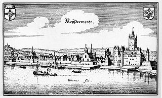
The Altstadt is one of the 50 quarters of Düsseldorf, Germany; it belongs to central Borough 1. The Düsseldorfer Altstadt is known as "the longest bar in the world", because the small Old Town has more than 300 bars and discothèques; supposedly, each establishment's bar-counter connecting to one next door.

<span class="mw-page-title-main">Golzheim</span> Locality of Düsseldorf, Germany

Golzheim is a quarter of Düsseldorf in Borough 1 on the Rhine, just north of the city center. It is primarily a business and hotel district, but retains some of the old stately villas.

<span class="mw-page-title-main">Düsseldorf-Benrath</span> Quarter of Düsseldorf in North Rhine-Westphalia, Germany

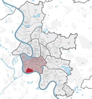
Benrath is a quarter of Düsseldorf in the south of the city, part of Borough 9. It has been a part of Düsseldorf since 1929. Benrath has an area of 5.99 km2 (2.31 sq mi), and 17,178 inhabitants (2020).

<span class="mw-page-title-main">Volmerswerth</span> City district of Düsseldorf, Germany

Volmerswerth is a Stadtteil (quarter) in western Düsseldorf, Borough 3, by the river Rhine. It borders the quarters Hamm, Bilk and Flehe. It has an area of 2.22 km2 (0.86 sq mi), and 2,336 inhabitants (2020).

Dresden is a large city in the eastern Saxony nearby the border to the Czech Republic at the river Elbe. The geography and urban development of Dresden is embossed by the valley location and by the Elbe stream.

<span class="mw-page-title-main">Düsseldorf-Hafen</span> Stadtteil of Düsseldorf in North Rhine-Westphalia, Germany

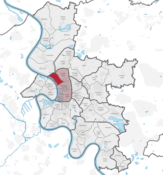
Düsseldorf-Hafen is an urban quarter of Düsseldorf, Germany, part of Borough 3, located on the river Rhine and the location of the city's docks.

<span class="mw-page-title-main">Pempelfort</span> Locality of Düsseldorf, Germany

Pempelfort is a city part in the North-east of the central Borough 1 of Düsseldorf.

<span class="mw-page-title-main">Oberbilk</span> City district of Düsseldorf, Germany

Oberbilk is an inner-city urban quarter in the south-east of the German city of Düsseldorf. The back exit of the Central Station leads to Oberbilk. The new District Court of Düsseldorf is located in Oberbilk since 2010, as is the main office of the Communal Library of Düsseldorf. Oberbilk is also home to the Mitsubishi Electric Halle, a concert arena with a capacity for 7,500.

<span class="mw-page-title-main">Düsseldorf-Unterbach</span> City district of Düsseldorf, Germany

Unterbach is a quarter (Stadtteil) of Düsseldorf, part of Borough 8. Until a local reorganisation in 1975, it was a part of Erkrath, Germany. A portion of the pre-1975 Unterbach remains as the quarter of Erkrath-Unterfeldhaus. The eastern end of the borough of Düsseldorf-Vennhausen was attached to Unterbach during the reorganisation since it was already culturally associated with Unterbach.

<span class="mw-page-title-main">Unterbilk</span> City district of Düsseldorf, Germany

Unterbilk is an urban quarter in Borough 3 of the North Rhine-Westphalia state capital Düsseldorf. It is the seat of the Landtag of North Rhine-Westphalia, the Rheinturm tower and, together with the Düsseldorf docks is the centre of the media industry in Düsseldorf.

Cologne is Germany's fourth-largest city and the largest city in the Rhineland. As of 31 December 2011, there were officially 1,017,155 residents. The city is center of the Cologne/Bonn Region with around 3 million inhabitants.

<span class="mw-page-title-main">Borough 1 (Düsseldorf)</span> Borough of Düsseldorf in North Rhine-Westphalia, Germany

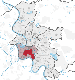
Borough 1 is the central borough of Düsseldorf, the state capital of North Rhine-Westphalia, Germany and the city's commercial and cultural center. The borough covers an area of 11.31 square kilometres and has about 86,000 inhabitants.

References